Ontario Pathways Rail Trail, Sunday, March 2 – 2:00PM

Trail head parking at (42.8965,-77.2462)

The big bridge in CanandaguaThis Sunday (weather permitting) we are returning to the Ontario Pathways Rail Trail, east of Canandaigua.  This trail was created by a group of dedicated hikers (like us) in Ontario County, who converted a former railroad bed into a very user friendly level trail.  The trail goes from Canandaigua to Phelps, traversing much of Ontario County.  We will hike a small section of the western part of the trail.

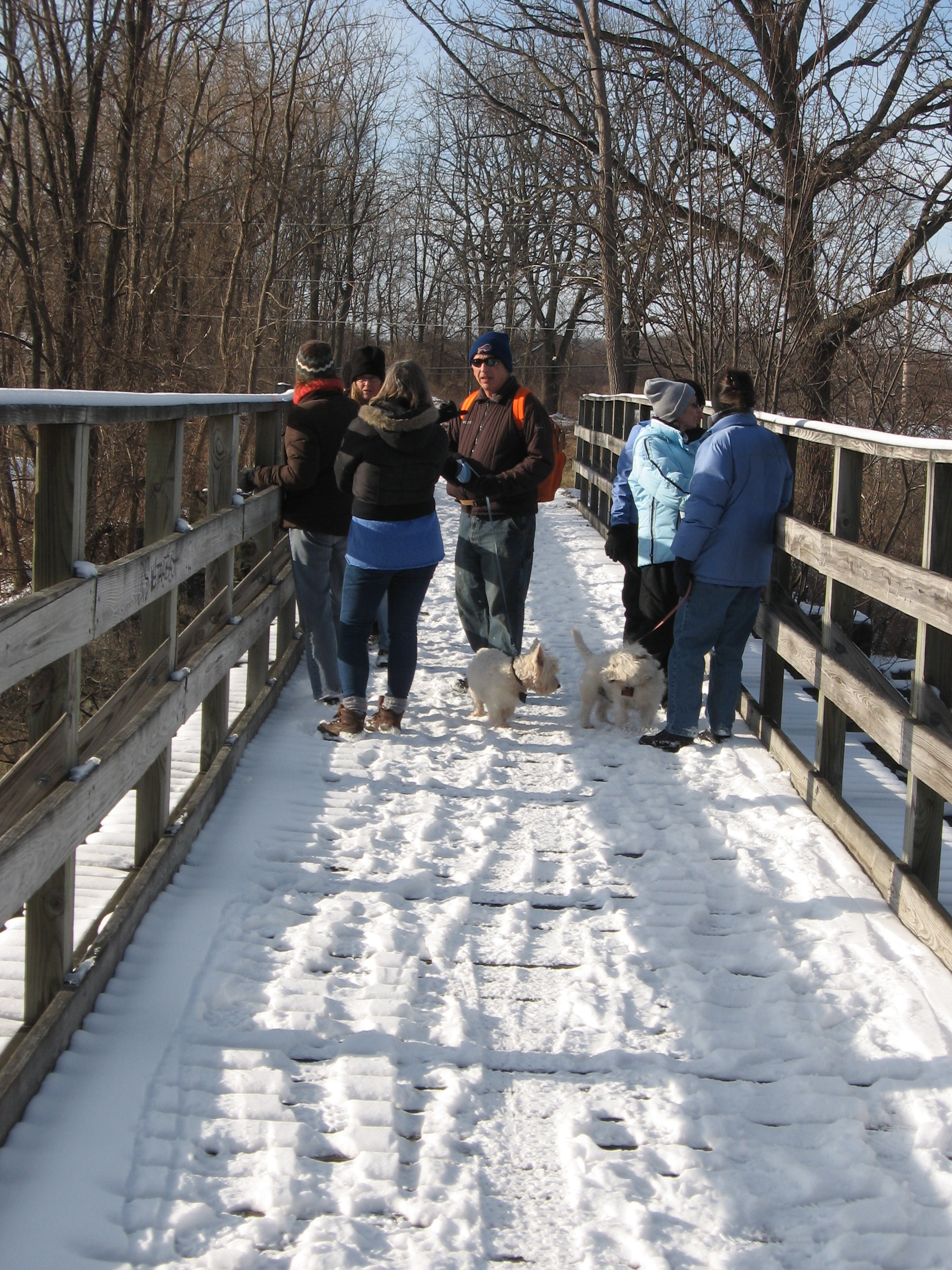
The pre-hike, Thursday afternoon, was cold and windy so Mac and Duff decided to wait for Sunday to see most of the trail.  The trail is snow covered with a base of rough ice.  It doesn’t appear that snowshoes will be much help, but spikes, cleats or yaktrax are recommended.  The rough ice probably would make skiing uncomfortable.

Ontario PathwaysOur meeting place is the trail parking lot on the west side of County Route 10, just north of CR 46.  Enter at the north entrance of the Ontario County Fairgrounds and park along the trees by the trail. From the north on CR 10, parking is on the right just past the hiking trail sign.

The trail head is 35 miles from Springwater.  A self-managed optional carpool will meet at the Springwater Town Hall parking lot at 12:50 PM  and will leave promptly at 1:00.    Let’s try to get to our hike starting site by 1:45, since we have to organize car spotting at the hike end sites.

An alternate carpool will meet at the the Richmond Town Hall in Honeoye at 1:10 and will leave promptly at 1:15. Cars coming from Springwater should stop at Honeoye to pick up any hikers who are there.

Ontario Pathway Route
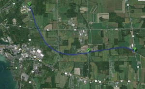
All hikers will head east on the Ontario Pathway. The satellite view to the right and the Ontario Pathways map show the farmland we will hike through. The first pickup point (B) will be just under 3 miles, at Freshour Rd. The second pickup (C) is about 4 miles, at County Rd. 47. Some hikers may explore a bit past the pickup points and return to the pickup if time permits. Both pickup spots are easily reached from the CR 10 parking area by going south of CR 10 and taking the first left on CR 46.  Freshour is the second right and CR 47 is the third right.  Trail parking on Freshour is on the east side of the road at the trailhead.  There is similar parking on the east side of CR 47, but if it isn’t plowed, we can leave a car on the west side.

Canandaigua has many restaurants.  We will decide between the Bee Hive Brew Pub, Eddie O’Briens Grille, and the  The Villager for an optional after hike social. Leave a comment on your favorite!  Sunday is expected to be 22 degrees, but we will need to warm up after the hike!

Directions:

If you wish to carpool please follow these directions to the Town Hall.  Since you may need to drive in the carpool, please bring the following directions to the trail head.

From Springwater Town Hall: Go north from the town hall, through the flashing light on route 15A for 10.8 miles.  Before Hemlock, turn right onto Rt 20A east toward Honeoye.  Hikers near Honeoye can meet the carpool at the Richmond Town Hall in Honeoye at about 1:15.  Continue on 20A to the T at Rt 64 North.  Turn left on Rt 64 for 6.9 miles, then right onto Rt 5 & 20 at the light.  After 4.2 miles, Rt 5 & 20 bears right, but we will continue straight on West Ave Extension into Canandaigua.  Continue across Main St onto Ontario St.  You will see the pathway crossing Ontario St twice before the traffic circle.  Turn right at the traffic circle on CR 10.  Parking is on the right 0.4 miles south on CR 10.

From Rochester: Take the Thruway East to Exit 44. Merge onto Rt 332 south toward Canandaigua for 8.9 miles.  There is a stop light where Rt 21 joins Rt 332 from the left. At the next light, turn left onto Ontario St (It is Ontraio St on the left, West Ave on the right side of Rt 332 (Main St).  Follow Ontario St  for 2.0 miles, then right onto CR 10.  Parking is on the right 0.4 miles south on CR 10.


Finger Lakes Trail in Swain

On the last Sunday in January, 8 hardy souls braved the bone chilling weather to enjoy the winter wonderland in Swain.  Fresh snow was still clinging to the branches of the hemlock and hardwood trees.  The hikers divided into 2 even groups.  All hikers started on the main trail, that primarily followed an old railroad bed.

IMG_0049WThen, the Rambo hikers, led by Duffy and Mark (in that order), scampered up the Robinson Loops, starting on the orange trail. During the climb up the central gully, the temperature continually rose resulting in the need to remove a layer of winter wear before the top.   At the second junction of the blue, they switched over and cross the open fields at the top of the hill. Temperatures of course dropped quickly in the open wind.  At the trail junction in the fields, the other climbers convinced Mark to check the map, avoiding a needless trip down the the wrong road and back.  A few more slips and slides down a rutted logging trail and the hikers returned to the main Finger Lakes trail..  Returning to the lot by the main trail, they completed a vigorous 4-5 mile workout.

The more leisurely hikers enjoyed a stroll down the mostly flat main trail (except for a fairly steep stream crossing) up the junction of the blue, and back, for a total close to 3 miles.  After the hike, we got to warm up and enjoyed fellowship and fine fare in the back room of the Sierra Inn, reviewing this hike, and looking forward to some great future ones that Rick, and his hike leaders, have planned for us.IMG_0136


Finger Lakes Trail in Swain

This Sunday, January 26, 2014, at 2 PM, we will be hiking a section of the Finger Lakes Trail, east of Swain.  The hikes will begin and end in Swain.  Following the hike, we will gather at the Sierra Inn,  in Swain, for a warm social.

To get to the parking area, from Dansville, go south on Clara Barton St., which becomes route 36.  Turn right on 70, past Canaseraga, and left on 24 into Swain.  Make a left on  Mill St, opposite the Sierra Inn, and, at the end, you will come to a parking area, across from the tubing hill.  Be sure to go all the way to the end of Mill St.  The lot has a tall wall on one side and, unless you come ealry, you will be greeted by our friendly sign.

Since parking may be limited, Gene will be at the parking lot by the municipal building, in Dansville, at 1:10, for those who would like to carpool. The lot is located on the west side of Clara Barton St., just south of Main.  Plan to leave promptly at 1:15.

Swain Ski AreaAll hikers will cross a field and climb a short hill to the main, white blazed, trail, which then goes along a level railroad bed for about half a  mile to the junction with the orange trail..

Naturalists Hike

Naturalists

The naturalists will stay on the main trail (red line on the attached map) to the junction with the yellow trail (shortly past the blue trail) loop and take the yellow trail back.  (if conditions prohibit the yellow trail, the naturalists will return on the main trail).  Total distance is about 3 miles.  Because the trail is level, if there’s any snow, it’s good for snowshoes or XC skis.

Tourists

Tourists

Tourists will enter the orange trail, on the right side of the trail and follow it up the gorge.  At the top, this group will turn left on the 2nd blue trail connection, hike it back to the main trail, and return by the main trail.  The total hike is about 4 miles (dark blue on the left map).  Climbers take the orange loop.Climbers will also enter the orange blazed loop, on the right, then take the first right to hike the orange trail counter-clockwise back to the main trail.  This loop is 2.3 miles, making the total hike (green line on the right) also about 4 miles.  Although the climbers hike may actually be a little shorter than the tourists, the orange loop has a steep climb up near the beginning. With this information, you can decide which one you would prefer.  If there’s snow, snowshoes can be used on the loop trails but, they are a bit steep and narrow for XC skis.  Maps will be available for leaders and sweeps.  When ending the hike, watch the blazes so you don’t miss the right turn off the railroad bed, to get back to your cars.

After the hike, the social will be at the Sierra Inn, in Swain.  They will have a table for us in the back, around 4:30.  There is a well stocked bar and a big menu with many choices including wild game and conventional dinners, burgers, pizza, and many bar items.  Prices are reasonable and they often have specials.   After the social, some of you might like to stay and enjoy the ski resort’s great downhill ski trails.

Directions to the start of the hike are available here.  From the hike parking lot, the Sierra Inn is back on Mill St to CR 24 in Swain.

Comments to start 2014

As we begin a new year, ever consider all we can be grateful for?  How about having the good fortune to live in an area that has distinct and diverse seasons.  This gives us the opportunity, on Sunday afternoons, to enjoy the diversity, on the many neat hiking trails, and other resources, in the Western Finger Lakes Region.  It’s also nice to look forward to a good, usually full course, Sunday evening meal, enjoying the great fellowship of our fellow hikers.

On December 22, Don and Marty introduced us to new trails at Tumble Hill Campground.  Most hikers climbed the hill and were rewarded with a close-up view of one of the Cohocton wind turbines.  Our gratitude to Dena and Marty for posting their nice article and pictures.  Isn’t it nice to see us getting our energy from a natural source, rather than desecrating our beautiful landscape by subterranean shale fracturing?  If you want to see what it does, just cross the state line, into Pennsylvania.  Debra, the campground manager, is enthusiastic about our group, and welcomes our participation there.  I talked to her about coming back, maybe in July.  Let’s hope it’s a hot, sunny day, because they have a small lake, where they have built a swimming beach, with tables, where we can have our social, and get pleasant relief from the heat.

Our gratitude also to Tom and Jerri for sharing their fantastic vacation and adventure in New Zealand.  It’s always nice to enjoy other areas in our diverse planet.  For what it’s worth, this can help you enjoy it more.  We are the only country in the world that still uses the antiquated, English origin, measuring system.  Every other country is now using metric, including Canada.  So, if you learn the metric system, which is very easy, and “think metric”, you’ll have a better understanding of what they’re saying.  This way, if they tell you the temperature is 30 degrees, you won’t go for your sweater.  If you must convert Celsius to Fahrenheit, a quick way is to double the Celsius temp, and add 30.  Try it with 30 degrees C.

And, we definitely owe a big debt of gratitude to Rick, for planning 3 months of some pretty terrific hikes.  Looks like he’s leading most of them, himself.  If you haven’t volunteered to lead a hike this period, I’m sure he would appreciate any help you’d care to give him.

See you on the trail, in our winter wonderland.