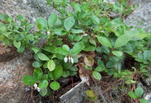
When we hike in the late fall, early winter it can become difficult to determine what some of the plants along the trail are. Many are displaying their seed heads and dried leaves. There are some herbaceous plants that remain evergreen and are easy to identify. One of these beauties is a woody ground cover called Wintergreen (Gaultheria procumbens). The plant has shiny green leaves and red berries. The best ways to identify it is to break or crush a leaf then smell it. The aroma of wintergreen is wonderful. Continue reading
Monthly Archives: November 2012
Hemlock Lake Park – Directions
The Hemlock Lake Park is located at the North end of Hemlock Lake. There is a picnic shelter and outdoor picnic tables.
From Hemlock: Head south on 15A. At 0.7miles past the intersection with 20A, take the first right onto Rix Hill Rd into the Hemlock Lake Park. Take the third left into the parking area.
From Springwater: Head north on 15A for 10.1 miles. Turn left on Rix Hill Rd. Take the third left into the parking area.
From the North: Take Exit 9 off of Interstate Highway 390. Travel south on State Highway 15. In Lakeville turn east on State Highway 20A, follow 20A just past the hamlet of Hemlock. Continue straight on State Highway 15A when 20A goes left. After 0.7 miles take the first right onto Rix Hill Rd into the Hemlock Lake Park. Take the third left into the parking area.
From the South: Take Exit 3 off of Interstate Highway 390. Travel north on State Highway 15. In Springwater continue straight onto State Highway 15A. 10.1 miles north of Springwater, turn left on Rix Hill Rd. Take the third left into the parking area.
Mendon Ponds Park – Dec 2, 2012 at 1:00
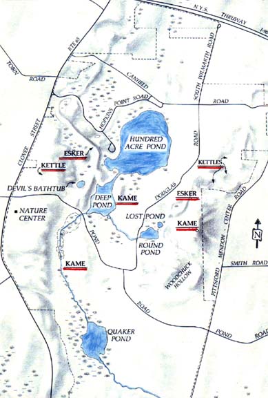
 This Sunday, December 2, 2012 at 1:00 (note time change) we will explore Mendon Ponds, one of Monroe County’s largest parks. Mendon Ponds was designated a National Registry of Natural landmarks in 1969 due to its dramatic geological glacial formations including kettles, kames and eskers. The 2,500 acre park offers many types of recreational opportunities including 30 miles of hiking, biking and equestrian trails, boating, fishing, sledding, cross country skiing, lodges, a nature center, an injured raptor bird center called Wild Wings and a sensory garden for the disabled.
NOTE: The hike this week will start at 1:00PM rather than 2:00 to allow access to the Nature Center and Wild Wings at Mendon Ponds Park. We will meet at the Masterson House on Junction Rd at 1:00 and then car pool to the Nature Center. Dogs (on leashes) will only be allowed on the Climbers hike which will avoid the birds at the Nature Center. Continue reading
What is an esker?
Since I never took Earth Science I am going to refer you to several good resources about the remains left by the receding glaciers of the last Ice Age. There is a nice brochure published by the Monroe County Department of Parks about the the specific Glacial Geology at Mendon Ponds Parks. I will bring a few copies to the Dec 2 hike.
The following descriptions have been extracted from the references below.
Kame: Hill of stratified drift that forms when a stream deposits sediment in a hole in the glacial ice.
Kettle lake: This is essentially the opposite of a kame. When a block of glacial ice is stranded by a retreating glacier, it prevents sediments from being deposited. When it finally melts, a depression is left.
Esker: Streams flowing through, in and under the glacier carried much rock waste. Frequently these bits of sand and gravel mixed with boulders settled in the stream channel. When the ice melted there was nothing to hold them in place and they slumped to form long, sinuous, roughly stratified hills.
Drumlin: A glacier picks up and carries rock material. This probably accumulated along the edge of the ice sheet. Ice pushing against it probably rode up and over it shaping it into elongate, oval hills called drumlins. Drumlins probably developed as the ice sheet pushed southward.
Moraine: As a glacier started to melt, the melting ice furnished great quantities of rock material, which streams, emanating from the ice, dropped along the front edge of the ice sheet. The great piles of waste material accumulated in what is known as a terminal moraine. Continue reading

