About Mark

President of Springwater Trails, Inc

Canadice Lake Northwest to Rob’s Trail – April 12, 2014 – 9:45-11:45AM

Notice: The Springwater Trails hike at Durand Eastman has been postponed until April 27th when we expect the spring blossoms to finally be here.  So this weekend, we have two hikes available to Springwater hikers thanks to our sister clubs – the Victor Hiking Trails and the Crescent Trail Association. Pick either or both and get to know new hikers!

On Saturday April 12th, Victor Hiking Trails will lead a hike on the west side of Canadice Lake on the trails on NYS property. The hike will be 3 to 4 miles on varying terrain. Bring a bag lunch and something to drink. Dress for the weather and wear sturdy hiking boots. Meet in the rear parking lot at Victor Town Hall, 85 East Main Street at 9:00 a.m. to carpool to the trail head. Or meet at the parking lot on Purcell Hill Road between State Route 15A and Canadice Lake Road at 9:45 a.m.

Map.

Directions to the trail head.

Additional details can be found by calling 585-234-8226.

Valentown to Woodcliff – April 13, 2014 – 1:30-3:30PM

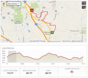
Click on the map for an interactive version of the hike route.

Click on the map for an interactive version of the hike route.

On Sunday, April 13, 2014, the Crescent Trail Association is celebrating the connection of the Victor Hiking Trails and the Crescent Trail.  The trail connection on Lasalle Pkwy joins the 35 miles of pathways in the Crescent Trail system, to the 37 miles within the town of Victor.

This will be a one-way hike.  Meet in the small parking area along the dead-end street on the north side of Victor’s large wooden-sided Valentown museum building (southeast of Eastview Mall).  Hike on hilly trails, starting on a new section of Victor’s Seneca Trail, connecting with Perinton’s Crescent Trail at LaSalle Parkway.  The hike continues on the Crescent Trail to the Woodcliff Hotel and Spa.  Shuttle transportation will be provided to transport hikers from Woodcliff back to Valentown.

The view from Woodcliff at the end of the hike.

The view from Woodcliff at the end of the hike.

Hikers from Springwater should meet at the Springwater Town Hall at 11:50 to carpool to Victor. Please email Gene at [email protected] if you are planning to go to this hike. Gene will plan the staging of cars for this one-way hike.

Directions

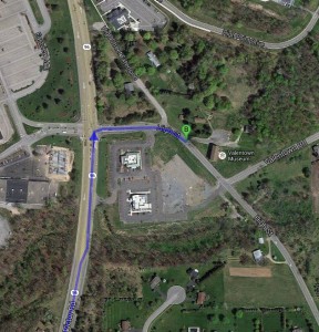
From Springwater Town Hall: Head north on Rt 15 to 15A at the light. Bear right onto Wheaton Hill Rd (CR 16).  Take the first left onto Canadice Rd. (CR 42). Bear right to stay on CR 42 which becomes CR 37 in Ontario County.  Follow CR 37 to Canadice Hill Rd.  Turn left to stay on CR 37 through West Bloomfield and Rt 65 North.  Continue straight on CR 35, when Rt 65 curves to the left.  Stay on this road (W Bloomfield Rd) for 5.8 miles.  Turn right onto Rush Mendon Rd (NY 251 E).  ValentownFollow NY 251 for 3.4 miles.  Turn left onto Phillips Rd (NY 251 curves to the right at this intersection).  Notice the Lehigh Valley Trail and the Auburn Trails which cross Phillips Rd.  You may have already seen the Lehigh Valley Trail crossing NY251 and W Bloomfield Rd on its way to Rush, the Genesee River and the Greenway. At the light, turn right onto Main St Fishers (CR 42).  Turn left onto Rt 96N to go under the thruway, then over 490.  At 1.2 miles, turn right onto High St. The parking lot behind Valentown is the second left off of High St (0.1 miles).
[For those of you who read this post Tuesday morning, my sincere thanks to Don for pointing out that trails are measured in miles and that, if fact, there are no nukes in Victor!  And if you are wondering, try typing miles with your right hand resting above the HJKL keys rather the the JKL; keys.]

Annual Meeting

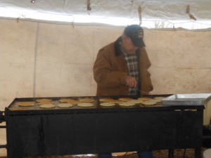
maple weekend 136Springwater Trails had a busy day on Sunday.  The day started before 8:00 AM when Char, Pati and Bob headed north from Springwater to serve pancakes at Stoney Ridge Maple Farm.  They were joined by John, Linda and Mark who traveled from Fairport. In spite of the wind and cold, and all of our nervousness, the weekend proceeded smoothly.  maple weekend 116But looking back, how can you fail will a meal consisting of fresh Maple Syrup supported by pancakes.

The afternoon hike was made possible by Bob, Joe, Char, Patti and the Masterson’s who held the fort at Stoney Ridge.  Fifteen hikers “enjoyed” an icy and windy hike to the top of the Giles/Schribner hills for views of the Springwater valley and then met for a social and the 2nd Annual Meeting for Springwater Trails, Inc.  Gene provided a lively discussion about the Hemlock Woolly Adelgid.  Over the next 5 hikes, Springwater Trails will be looking for signs of this invasive insect that attacks Hemlocks as close to Springwater as Watkins Glen and Letchworth Parks.

Official business of the Annual meeting included the adoption of By-laws from the group and election of officers for 2014.  Thanks to Rick, Melissa, Katherine, Joan and Mark for agreeing to serve.  And thanks to everyone who has volunteered with the group to coordinate and plan our hikes, to help build and maintain our trails, to help with our fund raising, or most importantly to share some time with us during our hikes.


Indian Fort Trail – Directions

You may want Geocaching directions.

DIRECTIONS:   The preserve is located at 3432 Jones Bridge Road.  There is no sign identifying this branch of Jones Bridge Road.

From Springwater: There are many options from Springwater including taking I 390N from Wayland to Mt Morris (see below).  The route with the fewest turns takes Rt 15 N out of Springwater for 1.5 miles.  Turn left onto Liberty Pole Rd (CR 38) and follow that road for 8.1 miles (it will change names and CR numbers two times) to NY-63.  Turn right and follow NY 63 for 8.3 miles (there is a right turn staying on NY 63 [Mt Morris-Geneseo Rd] after 6.4mi). The Preserve is on the left and the kiosk can be seen from the road.

From Mt. Morris exit of Rt 390:   North on Rt. 408, which becomes Rt. 63.   Stay on Rt. 63 for 2 miles.  The Preserve is on the left and the kiosk can be seen from the road.

From Geneseo:  Head south on Rt. 39/Rt. 20A.  At the traffic light where Routes 20A and 39 turn to the right, continue south on Rt. 63 for 1.2 mile.  The preserve is on the right and the kiosk can be seen from the road.

From Rochester: Head south on I 390 S to Exit 8.  Turn right onto US 20A for 4.9 miles.  Turn right onto Mt Morris Rd (20A and 39S). At the traffic light where Routes 20A and 39 turn to the right, continue south on Rt. 63 for 1.2 mile.   The preserve is on the right and the kiosk can be seen from the road.

From Honeoye:  Follow Rt 20A west to Geneseo. Turn right onto Mt Morris Rd (20A and 39S). At the traffic light where Routes 20A and 39 turn to the right, continue south on Rt. 63 for 1.2 mile.   The preserve is on the right and the kiosk can be seen from the road.