It is sunday afternoon, March 16, 2014. The storm that was tropical cyclone Lusi has long ago been reclassified as a tropical depression, unworthy of a name. It sits off the North Western side of the South Island, after having struck the North Island a significant blow, and bounced off again. It is expected to pass through to the East this evening. I sit on the North West coast, comfortably out of the weather in a small cabin, and watch the progress. We originally expected the peak of the wind and rain to occur this morning, it looks like it was some hours late in coming. There was a strong wave last evening, around 18:00, which was fitful with a lot of energy. I thought that if it increased in intensity from there for twelve hours, it would be truly worrisome by morning. Instead it subsided to nearly nothing. Another wave started today around mid morning, but it was not as strong. Now, it appears that the strongest wave yet is in progress, and it has no indecision about it. The wind and the rain are constant and heavy. I have been able to catch up on my Facebook and email duties, and my sleep. When this wave subsides, I will go down to the only store in town, in the same building as the reception area for the holiday park, and order Take Away. They have the usual menu. Several kinds of fish, squids, and sausages dipped in batter, and chips (french fries), all deep fried. The quality varies, but the small town stuff is usually the best. I bought a bottle of wine there yesterday. The guy at the counter said ‘drink it all at once or it won’t do any good’.
Holiday Parks
The Holiday Park is something new in my experience, and i like it a lot. Perhaps because of Scottish cultural influences, the tourism industry caters to the thrifty. The Campervan is quite popular, and you see a great number of them, almost all rentals. It’s a camper made from a conventional van, Nissan for example, often with a raised roof area like the old VW bus campers we used to see in the states. It has the two seats in the front with a sleeping platform in the rear, under which are storage compartments accessible via the side and rear doors. It’s outfitted with curtains for privacy, although the springy suspension sometimes gives clues as to the activity inside. Larger ones based on Mercedes Benz or VW chassis represent the high end, but there are no city bus sized RVs as in the states. Back to the Holiday Park. It’s a complex with a range of accommodation options, all the way from motel rooms with private toilet facilities, called En Suites, to Standard rooms and cabins with shared toilet facilities, to bays for campervans with electricity, to tent sites. The grounds are often caringly landscaped, making me think it’s a business well suited for the avid gardener. Amenities include toilet, shower and laundry facilities, kitchen with fridge and freezer, coin operated internet facilities, and always, a TV room. I have pitched my tent in several of these Holiday Parks, twice in elaborate gardens. The fee has been 20-23 kiwi dollars, but I get a lot for that. I can cook with their fuel (camping fuel is expensive), charge all my batteries, freeze water for the chilly bin (that’s four bucks right there), and take a hot shower. Internet service is usually 5 dollars extra for 24 hours, which i can stretch over a two night stay. It is not uncommon for people to sleep in their cars. A young man and woman both somehow slept in one of those teeny Fiats one night. I’ve only done it once, because of the cold down south, but also as an experiment. It wasn’t bad, but my bedding in the tent is more comfortable, and has since then justified the setup and teardown.
Fellow Tourists
I meet few American tourists. The largest group are German speaking. The Austrians and Swiss fooled me at first, but a young German man told me that they do speak German, but with a strong accent and use many words the Germans find archaic. The next grouping would be the French speaking and about the same number of middle eastern sounding languages, which i do not recognize. Some of the French speaking are probably Canadian. I met a couple from Nova Scotia, and we puzzled over the switches on each electrical outlet in NZ. If a wall plate has two outlets, it also has two switches, one for each outlet. Wondering at the reason for this additional expense, I suggested bribery from switch makers. The wife said ‘same as our home’, and the husband, knowing I was American, said ‘we adopt all your ways, good and bad’. There are a number of Japanese, about as many as Americans. The Americans and Japanese may be on the Tour buses, however, since i did see one unload a herd of elderly Japanese. But when it comes to younger people tramping and camping, it’s mostly Europeans.
Pride and Prejudice
I just finished Pride and Prejudice. I have a friend in Rochester who belongs to a Jane Austen society. That was the immediate catalyst, but I had noticed historians like Paul Johnston often refer to Austen’s work for details of English Society of the times. The clergy as a politically appointed source of income for a nobleman’s sons. The passing of fortunes and estates to one’s heirs, the practical considerations of marriage. In short, the relationships between one’s position in society and financial opportunities for him, and most critically for her. I had recently read an article in Harper’s on the Romance category of the print media industry. It is by far the largest in terms of sales, outselling the nearest contender, Inspirational, by $700M. It’s authors are the best paid in the industry. The article reported on a convention sponsored by the industry with workshops, for a fee of course, on how to write best selling romance novels. The plots all share common elements, centered around the Happy Ever After ending, referred to in the industry as HEA. The successful novel, it was reported, would have the first part of the book developing obstacles and hurdles to HEA, and the last part having the hero and heroine striving like mad to overcome them. Well, P&P wasn’t much different in that regard, but the language usage was delicious, and I loved it for that reason. Reminded me of a summer spent in the hammock reading Moby Dick. Two very different stories, same delightful language usage. “as arrant topers, freshly landed from the sea, the liquor soon mounted to their heads, and they began capering about most obstreperously”, that sort of thing, as i still remember from Moby Dick, cracks me up.
It continues to storm with much energy. This wave has lasted several hours now. I look forward to what Monday morning will bring. Overall on the trip so far, the weather has not been the best. The day I arrived was cold and rainy, with a high around 10degC. The next two weeks were mainly sunny and warm. I developed a moderate sun burn which peeled and gave way to bronze summer skin. When i left to tour the South, it was cold and rainy again. The whole reason for starting in the South was to catch it early in the cycle when it would be the warmest. Although it rained each night in Dunedin, and the mornings were chilly, the days were nice and sunny. The trip from there down to Invercargill was intermittent rain, and nearly constant strong headwinds. I sat out the rain in Invercargill for two days before going to Stewart Island in a short sunny and calm window, and sat out another two days when I returned to see if it would improve enough to tour the Fiordlands. It didn’t, i gave up, and passed through Queenstown for a night before heading up the West coast to the parks on the North coast. I had about a week of nice weather through the Southern Alps and glacier country, and on into Nelson, where it started raining again. I holed up there three nights before heading for Totaranui in the Abel Tasman National Park. I had a window of two really nice days there. It was in Nelson that I first heard of Lusi. She turned out to be not nearly as well organized as the last cyclone to hit the Golden Bay area ten years ago, which took out roads and caused many slips (landslides). Still, she had energy enough in her to blow and rain hard these last 36 hours. Regardless, I have had enough good weather to see plenty of the incomparable beauty of this country. One of the reasons I came for three months is to have enough time to contend with the inevitable ups and downs of the weather. Tonight, I am very happy to not be in the tent. The forecast is for improvement throughout the upcoming week.
Aftermath
Luci’s gone, now, leaving the locals disappointed at not getting more rain. The last few days have been sunny and warm after the passing of the Cyclone. i toured the Farewell Spit area, and am going back to a Holiday Park i found near Wharariki Beach that is off the grid, so i’ll be out of touch for a while when i do that. If i like it i’ll spend a couple of days longer. I walked some of the tracks in the Pohara area. A waterfall thunderous with the flow of the cyclone aftermath. Going up a rocky ascent to some interesting caves, I tweaked something in my right knee, perhaps a ligament. I wondered if i was building up or tearing down with all this hiking i’ve been doing, and I suppose it’s a little of both. Went today to the Cobb river valley in Kahurangi National Park, but limited myself to a couple of hours on a relatively flat track along the river. There was debris on the track from the Cyclone, but not much real damage. The Cobb reservoir is dreadfully low, even after the storm, so it’s hard for me to feel sorry for myself when it rains. The access road is a 40km one lane gravel cliff hanger. If you meet somebody, you just have to hope there is a turnout not too far away so one of you can back up to it. This happened once after coming to a grinding halt, bumper to bumper. The other two cars I met were luckily at wide enough places in the road to pass. Knee feels just a little sore, but not bad, so I hope to try for the caves again tomorrow.
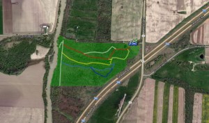
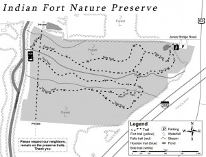 The property consists of sixty acres with gullies, creeks, a small field, a pond, and access to the Genesee River. Trails are well marked and go from the parking area on the northeast side of the preserve through the preserve to the Genesee River. Two waterfalls can be seen from the trails.
 Climbers will not find the main trails a challenge, but they can travel up the gullies to the waterfalls and climb the steep sides of the gullies. Tourists can follow the climbers and scale the gully walls before they get too steep. Flatlanders/naturalists will find easy hiking on trails that have slight hills and a lot of flat land.