
This hike was originally scheduled for March 30 and was postponed until April 6 to give everyone time to shovel the snow.
Indian Fort Nature Preserve (42.766,-77.8295) is managed and maintained by Genesee Valley Conservancy. It is known as “Indian Fort” because of the two palisades that once stood on the site. Two mounds are still visible where the wooden posts created a fenced enclosure between the two main gullies. These palisades date back to 1400 – 1500 A.D. The former Iroquois palisades prompted the area to be listed on the National Register of Historic Places in 1974. Because of the diverse botanical, cultural and geological features, the preserve has been designated a Research Reserve by the conservancy.
We will meet at 2:00 at the Preserve Kiosk on Jones Bridge Rd and Rt63. The hike will be followed by a social at CharredBar, 36 Main St., Mount Morris.
Ben Gajewski, Director of the Genesee Valley Conservancy, has agreed to lead an interpretive hike for all who care to learn more about the preserve.
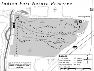 The property consists of sixty acres with gullies, creeks, a small field, a pond, and access to the Genesee River. Trails are well marked and go from the parking area on the northeast side of the preserve through the preserve to the Genesee River. Two waterfalls can be seen from the trails.
 Climbers will not find the main trails a challenge, but they can travel up the gullies to the waterfalls and climb the steep sides of the gullies. Tourists can follow the climbers and scale the gully walls before they get too steep. Flatlanders/naturalists will find easy hiking on trails that have slight hills and a lot of flat land.
A short hike on one of the trails on March 22 showed that most of the snow has melted, but there was still ice on some of the trails and the waterfalls were frozen. Hopefully, some warm weather this week will allow the water to flow over the falls and clear the trails.
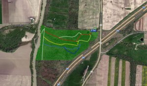
A map of the Preserve trails and parking location. Note that there is no bridge across the Genesee on Jones Bridge Rd.
DIRECTIONS: The preserve is located at 3432 Jones Bridge Road. There is no sign identifying this branch of Jones Bridge Road. Please note: Jones Bridge Road has three sections separated by the Genesee River and by I-390. The preserve is on the small section west of I-390 and east of the Genesee River.
From Springwater: There are many options from Springwater including taking I 390N from Wayland to Mt Morris (see below). The route with the fewest turns takes Rt 15 N out of Springwater for 1.5 miles. Turn left onto Liberty Pole Rd (CR 38) and follow that road for 8.1 miles (it will change names and CR numbers two times) to NY-63. Turn right and follow NY 63 for 8.3 miles (there is a right turn staying on NY 63 [Mt Morris-Geneseo Rd] after 6.4mi). The Preserve is on the left and the kiosk can be seen from the road.
From Mt. Morris exit of Rt 390: North on Rt. 408, which becomes Rt. 63. Stay on Rt. 63 for 2 miles. The Preserve is on the left and the kiosk can be seen from the road.
From Geneseo: Head south on Rt. 39/Rt. 20A. At the traffic light where Routes 20A and 39 turn to the right, continue south on Rt. 63 for 1.2 mile. The preserve is on the right and the kiosk can be seen from the road.
From Rochester: Head south on I 390 S to Exit 8. Turn right onto US 20A for 4.9 miles. Turn right onto Mt Morris Rd (20A and 39S). At the traffic light where Routes 20A and 39 turn to the right, continue south on Rt. 63 for 1.2 mile. The preserve is on the right and the kiosk can be seen from the road.
From Honeoye: Follow Rt 20A west to Geneseo. Turn right onto Mt Morris Rd (20A and 39S). At the traffic light where Routes 20A and 39 turn to the right, continue south on Rt. 63 for 1.2 mile. The preserve is on the right.
THE SOCIAL AFTER THE HIKE will be at CharredBar, 36 Main St., Mount Morris. Leaving the hike, follow Rt. 63/Rt. 408 to the traffic light at the main intersection in Mt. Morris. Turn right…the restaurant is just around the corner on the left side of Main St.