Posted on by

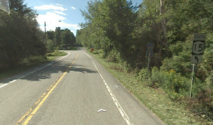
Stid Hill from Dugway Road

The primary purposes of Stid Hill Wildlife Management Area (WMA) are for wildlife management, wildlife habitat management, and wildlife-dependent recreation. This WMA is a 847-acre tract of land situated in the townships of Bristol and South Bristol in Ontario County. It is bounded by Route 64 on the west and Dugway Road on the north. Ganargua Creek, better known as Mud Creek, flows along Route 64. At one time, Stid Hill was productive sheep and cattle grazing land. Today, grazing has been eliminated. The mixture of steep hills, ravines, gullies, gorges, woods, and open areas create scenic vistas and also provide varied wildlife habitats.

The hike on Sunday Sept 29th will begin at the Dugway Road trail head @ 2:00; please arrive by 1:45. There is only a small parking area here, so please pull off and park on the shoulder near the trail head. The trailhead is easy to miss – it’s just a widening of the road after a sharp turn. The trail head is on the south side of the road and marked with a discreet DEC sign a little too far from the road.There are two loop trails from here as well as a trail that continues over the hill to the blue and yellow trails, which go down to the Rt 64 trailhead. Today we will be hiking both of the loop trails (1 to 2.5 miles), and the Climbers will venture beyond the loop trails and farther into the WMA (3-4 miles). Please bring good footwear and poles as needed.

From the trail head, the initial quarter mile is a good path, although it may be a bit wet and slippery if there has been recent rain. You will come to a prominent “Stop” sign and a gate. This is a little misleading; there are public trails to the left and right if these barriers. Both of these trails make up the short loop trail. Above this loop there is a much longer loop trail.

Climbers: Will cover a little more trail at a faster pace…they will continue up the incline (not a real serious one, as this area typically offers otherwise) then make a right into the denser woods. Arriving at several large shaggy hickory trees that have many yellow paint marks on them (probably used a bucket of paint here) we will turn left, continuing on the portion of the yellow trail that heads south, through a grove of thorn trees. We will then hike through a serene pine forest, and turn right onto a short trail that passes by an old pickup truck. Heading downhill, we will turn right onto the return loop through the pine & shaggy hickory forest.

Tourists: From the Stop sign, turn onto the trail to the left going up the ravine. There will be DEC signs on your right. At the first cross ravine, turn right and take the trail up the bank onto the top part of the short loop trail. Watch for the trail that goes uphill on the left, and turn here. Farther along, there will be some DEC Foot Trail markers. Continue until you come to an intersection where there are some larger trees with a lot of pink paint. Turn right on the pink trail, which is well marked and will lead you through the woods back to the intersection of the loop trails. From here, follow the wide pink marked trail down the hill and back to the Stop sign.

Naturalists: From the Stop sign, follow the trail to the right past a length of crash barrier, then uphill on a broad trail into the Stid Hill WMA. This trail is well marked with pink paint. Very shortly, you will come to a pink marked trail that turns left into the woods. This will take you to the intersection of both loop trails. Here you will take an immediate sharp left turn that crosses the top of the short loop trail. This trail does not have pink markers, but there are DEC Foot Trail signs (although they tend to be on the opposite sides of trees traveling this direction). This part of the trail can be a bit wet and muddy in spots. Continue to the end and turn left onto the ravine trail that will lead back down to the Stop sign.

After Hike Social:          Brew and Brats at Arbor Hill      6461 BB State Route 64 , Naples, NY   14512      (585) 531-4113

https://brewandbrats.com/     Approximately 6 miles from the Dugway trailhead via Rt 21 South

 Directions:

From the north: Starting at Route 5 & 20 in Bloomfield, drive south down Route 20A/64 for 5.3 miles to the intersection with Cty Rd 32 at Bristol Center. Continue for 1.4 miles and turn left on Dugway Road. If you come to a Stid Hill MUA parking area, you’ve come too far south – turn around and try again. Trailhead is on the right exactly 2.0 miles from Rt 64.

From the south: From the intersection of Rt 21 and 64 in Bristol Springs, drive north on Rt 64 for 6.5 miles. You will pass by two separate Stid Hill parking area signs on your right. Take the first right turn onto Dugway Road. It is 2 miles to the trailhead.

From Springwater, Head north to 20A, turning right just before Hemlock. Stay on 20A through Honeoye, and continue until it ends at Rt 64. Turn right and drive south on Rt 64 for 3 miles. Turn left onto Dugway Rd and go 2.0 miles to the trailhead.

Dugway Road is a good dirt road.  Please park carefully on the shoulder. There isn’t much parking space to be had.

Posted on by

Mushroom Hike

Katherine has invited us back to her farm in the beautiful town of Springwater to explore for wild mushrooms.  This is a great opportunity to pick some interesting mushrooms and learn about them from people who have studied them. You will learn which are safe to eat and whether any are good to eat.

Note: it is safe to pick mushrooms, but wait until you know what is what before you eat them.

Char will lead the Climbers. After checking in at the farm parking lot to sign the waiver and to receive the instructions on how to collect a specimen, the Climbers will carpool to Amanda’s Garden where Ellen Folts will host the group for an hour at her place. Then the Climbers will car pool to the All Western Evergreen South field Road entrance off Story Road and hike down through the wholesale trees A through E (back and forth through Fraser fir, Concolor fir, Korean and Turkish fir and notice the view, then back to Story Road to go through the Northwest Forest to the Cathedral pines, the south forest, across the choose and cut lots of Fraser fir, Korean fir and Concolor fir, to the North field road, scouring the hedgerow for mushrooms. Then we will hike up the farm road to Story road, staying on the farm land around the stone pile and back to the carpooled cars, drive back to the house.

Tourists will be led by Katherine or Carol: After checking in at the farm parking lot to sign the waiver and to receive the instructions on how to collect a specimen, the Tourists will hike to the south up through the woods and fields to Swartz Road and back through the Norway Spruce up by the pond and up through the Cathedral pines, across to the fields through O lots (correction strip trees), across the fields to the North field road down along the hedge row, through Scot Hill Triangle, down north field road along the hedgerow and just below the UVW fence, then through the woods back to the house where downstairs the mushrooms will be identified by Dr. Randy Weidner from RAMA and then we will have dish-to-pass social upstairs.

Naturalists: After checking in at the farm parking lot to sign the waiver and to receive the instructions on how to collect a specimen, the Naturalists, led by Gene & Georgia, will hike around the back yard behind the house including the Alaska Yellow Cedar, the nursery and up through the forest up behind all the houses along Liberty Pole Road, back up the hike path to the XY Douglas-fir and Concolor, through the fence around UVW across to the man gate at X center lot and then up the outside of the UVW fence to the Cathedral pines along the south field road and back to the house via the pond J Lot and forest back to the house where downstairs the mushrooms will be identified by Dr. Randy Weidner from RAMA and then we will have dish-to-pass social upstairs.

After the hikes, we will gather in the garage to see all of the collected mushrooms. Mushrooms will be identified by Dr. Randy Weidner from Rochester Area Micological Association (RAMA) from about 4:30 to 5:00. Hikers should plan their time to return to the house before that time.

Following the mushroom identification, join us for a dish-to-pass social upstairs.Please bring a dish to share (or make a small donation to the social fund) and your own beverage of choice. Water and tea will be available. Paper plates and plastic utensils will be provided unless you wish to bring your own place setting (and help save a tree). There will be space in the range oven and in the refriderator/freezers for your dishes if needed – please come in the garage and call upstairs if no one is there.

CR 60
Directions to 6840 Liberty Pole Rd, Dansville, NY (in beautiful Springwater, NY):

Note: It has been reported that some GPS systems use the center of the farm as the target location and send you to the wrong side of the farm. Before you leave check that the last road is Liberty Pole Rd and not Swartz Rd. Google Maps seems to know the location of the house. Or, use the directions below. There is a tree farm sign clearly visible at 6840 Liberty Pole Road and the house is visible from the road.

From Springwater: Go west from the Springwater light on Rt 15 North.  Just past the top of the hill, turn left on Co Rd  38 (Liberty Pole Rd).  The farm is on the left 1.1 miles from Rt 15 at 6840 Liberty Pole Rd.

From Geneseo: Go south on NY 63. About 6.4 miles after passing Rt 408, turn left on County Road 1 at Groveland.  This road becomes CR 1A at Scottsburg (rt 256) and then Liberty Pole Rd (CR 38).  It is 7.1 miles from Groveland to the All Western Evergreen Tree Farm.

From Honeoye: Take 20A west to Hemlock and 15A south to Springwater.  Then follow the Springwater directions.

From Rochester: Take I390 south to Exit 9 (NY 15 / Lakeville).  Turn left onto NY 15 and follow Rt 15 through Lakeville and Livonia (16.5 miles).  Just past Webster’s Crossing stay straight on CR 60 when Rt 15 bears left.  Take the first right off CR 60 onto Liberty Pole Rd (CR 38). The farm is on the left at 6840 Liberty Pole Rd.


Posted on by

FLT Series: Map 11, Access 2 to 5

In August, we hiked a section of the Finger Lakes Trail north west of Bath that primarily stayed in the woods. This Sunday we will go a bit west of Bath to a section that is more evenly split between fields and woods, which should keep all our hikers alert to follow the blazes.

The weather promises to be good, so following the hike, we will have a dish to pass social at the end of the Climbers’ hike. This is a change from the original posting.

We will meet at the middle of the 3.8 mile section on Snell Hill Road (Access 3). The Naturalists and Climbers will carpool to Access 2 on Harris Hill Rd and follow the trail east, around a swamp and up to the top of a level ridge. The first road is CR 69 which we cross onto a uphill road through the woods. This section ends with a walk along the edge of the yard onto Snell Hill Rd and the Naturalists cars.  The climbers will continue east. This next section is a little tricky. The trail starts with a short section along a field and enters the woods. There are a couple of sticks blocking the way between trees, but it is easy to get around and continue the trail though easy woods. The trail turns left to scoot down a hedgerow, but it is best to find a way out to the field on the left and stay along the edge of the hedgerow down to Gay Gulf Rd. It is a pretty road walk as Gay Gulf Rd cuts along a steep bank with interesting rock formations. In about 0.2 miles, the trail turns right up a steep road and continues to Robinson Rd. Across the road, follow the edge of the corn field on the right, and then enter a large woods. Take care, there has recent logging and the trail is rutted. The hike ends along a hay field to the Tourists cars on Sinclair Rd.

Meanwhile, the Tourists will carpool to Access 5 on Sinclair Rd. They will hike north west along the hay field, then into a recently logged forest to Robinson Rd. Continue across Robinson Rd, following the blazes to Gay Gulf Rd. Turn left and notice the rock wall on the left side of the road. You should pass cows on the left, before coming to a left turn into a driveway (watch for blazes painted on the guardrail entering the driveway. Pass between two farm buildings and turn left to the hedgerow.  Follow the edge of the field, Once the hedgerow on the left become more of a forest, you should be able to find a route into the woods to find the blazed trail. Continue down to Snell Hill Rd and the cars. At this point, check the time. The trail jogs left on Snell Hill and then continues west.  The Tourists should continue a far as desired, then turn around and return to Snell Hill Rd and the cars.

Directions: From Springwater, Wayland, Dansville etc: Take I-390 South toward Bath and Corning. Take Exit 1 (Avoca), and turn right on Michigan Hollow Rd. Turn left onto NY-415 for 0.8 miles. Turn right onto CR-70A just before the road goes under I-86. In 3 miles, turn left onto Bouten Rd. You will cross a creek and then stay to the left to keep on Bouten. The road name may change, but continue for 1.3 miles. Turn right onto Snell Hill Rd. The trail crosses the road in about 1.3 miles. Park along the road.

From Naples and Cohocton: From Naples, take NY-21 South to N. Cohocton. Continue straight for 5 miles to Cohocton. At the stop sign, continue straight onto NY-415 for 9.6 miles. Turn right onto CR-70A just before the road goes under I-86. In 3 miles, turn left onto Bouten Rd. You will cross a creek and then stay to the left to keep on Bouten. The road name may change, but continue for 1.3 miles. Turn right onto Snell Hill Rd. The trail crosses the road in about 1.3 miles.

Directions to hike starts

From Snell Hill Rd to Harris Hill Rd: Continue south on Snell Hill Rd, which becomes McChesney Rd. Turn right onto Turnpike Rd for 0.4 miles, then right onto Harris Hill Rd. In 0.7 miles, cross McCaddam Rd. The trail will be on the right in about 0.2 miles. Park on the shoulder.

From Snell Hill Rd to Sinclair Rd: Continue south on Snell Hill Rd, which becomes McChesney Rd. Turn left onto Turnpike Rd for 1.8 miles, then left onto Sinclair Rd. The trail is on the left in about half a mile.

Directions to the Social on Sinclair Rd

From Harris Hill: Return south on Harris Hill Rd to the stop sign at Turnpike Rd. Turn left on Turnpike Rd and continue for 2.2 miles. Turn left onto Sinclair Rd at a curve in Turnpike.The trail is on the left in about half a mile.

From Snell Hill: Continue south on Snell Hill Rd, which becomes McChesney Rd. Turn left onto Turnpike Rd for 1.8 miles, then left onto Sinclair Rd. The trail is on the left in about half a mile.


Posted on by

Taughannock Falls

The Hike

On Sunday 8th September 2019 we will hike in the Taughannock Falls State Park. 

The Climbers and the Tourists will hike the North and South Rim Trails starting with the North Rim Trail at the Taughannock Falls Visitor Center, crossing the river above the High Falls, and returning on the South Rim Trail to its end near the park entrance. If there’s some energy left they will hike the stream bed to the base of the High Falls. The Naturalists will start at the car park at the park entrance, and walk the stream be to the High Falls.

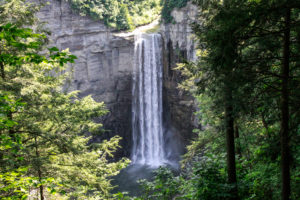
There is a lovely view of the High Falls from the North Rim Trail, and lots of views of the gorge along the South Rim Trail. There’s a terrific view of the rapids above the High Falls where the North Rim Trail turns over to the South Rim Trail.

This is a VERY easy hike. The trail is mostly broad and lightly surfaced, and there are occasional benches along the route for hikers like us to take in the view. Wherever the path gets steep, such as where the South Rim Trail drops down to the park entrance, there are stone steps. This is a very scenic walk, and is best done slowly with lots of stops to take pictures.

There is a small charge for entrance to the park.

Meeting Up

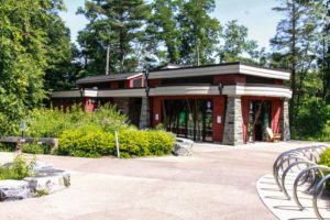
We’ll meet at the Taughannock Falls Visitor Center (pictured left, GPS coordinates 42.5391, -76.6073). The Climbers and Tourists will have shuttled most of their cars to the park entrance parking lot, and will give their remaining car keys to naturalists to take down the hill; the Climbers and Tourists will start their hike at the Visitor Center. The Naturalists will take all of the cars down to the parking lot at the park entrance and hike from the parking lot.

The meeting time is set to be 3:30pm at the Visitor Center. There is a little leeway here that allows for people getting lost, being late, and for organizing the car shuttle and the picnic location.


The Social

The social will be a picnic. We can decide at the beginning of the hike where to have it – at the small waterfall near the park entrance or by the lake shore. There are picnic tables in both places, but it is a Sunday and there will be other people around looking for tables too. There will be a small gas barbecue for heating up things. Please bring a dish to pass and whatever you like to drink.

Getting There

There will be a car pool organized, aiming to leave from the Naples public parking lot on Mill Street at 1:30pm. For those of you who want to drive themselves, here are the directions.

From Springwater, Honoeye and Naples: this route begins Naples. From Springwater and Honoeye, take your favorite route to Naples and pick up the direction on Rt. 21N. Google estimates the trip to be 1 h 44 min (83.9 mi) from Springwater.


Follow Rt. 21N (S Main Street) in Naples until you reach the junction with Rt. 245

Turn right onto NY-245 N
Drive 13.9 mi
 
Turn left onto N Main St in Rushville
Drive 0.3 mi
 
Turn right onto NY-245 N/NY-247 N
Drive 1.1 mi
 
Continue straight onto NY-245 N
Drive 10.1 mi
 
Slight left onto NY-14A N/NY-245 N
Drive 3.1 mi
 
Turn right onto Hwy 20 E
Drive 4.2 mi
 
Turn right onto NY-96A S
Drive 17.3 mi
 
Continue onto NY-96 S
Drive 3.0 mi
 
Turn left onto Center Rd
Drive 1.4 mi
 
Turn right onto NY-89 S
Drive 11.8 mi
 
Drive to Taughannock Park Rd
Drive 0.7 mi
 
Turn right onto Taughannock Park Rd
Drive 262 ft
 
Turn right at the 1st cross street to stay on Taughannock Park Rd
Destination will be on the left