Posted on by

Schribner Valley Winter Hike

Well, the title of this hike calls for winter activities, but I don’t see any snow, so please join us for an early spring hike.

We are planning three hikes for this coming Sunday (3/3/24). The Climbers will earn their stripes by climbing from the creek at the bottom of the valley up to the top of the surrounding hills (about a 300 foot climb). We will take a few minutes at the top to point out the approximate location where the sun should be during the April 8th eclipse. Expect about 4 miles hiking through woods and open fields with up some steep but comfortable slopes.

The Tourists will take a longer route to the top of the hill across the road for a different view. We are planning on a 3.5 mile hike primarily in woods.

Finally, the Naturalists will climb only about 100 feet to a trail through the woods along the valley. This will be about 2.5 miles depending on time.

Please join us after the hike for a social. If the weather behaves, we will set up a picnic out by a fire with marshmallows for former scouts.  Bring a  dish to pass and your own beverage (or donate to the social fund).

Directions:

Please note that Schribner and Giles Roads are seasonal between Strutt St and our home. Without snow they may be passible, but we recommend you use Quanz Rd to Giles off Strutt St. But preferably use Tabors Corners Rd to get to Schribner.

From Springwater: Head north on Rt 15A from the light in Springwater.  Take the first right on Wheaton Hill Rd (Co Rd 16).  Turn right on Wetmore Rd at the stop sign at the top of the hill.  At the end of Wetmore, bear right on Tabors Corners Rd.  After 3.5 miles turn right on Schribner Rd.  The driveway is on the left one mile up Schribner Rd and about 10 feet before the intersection with Giles Rd. There is room for a few cars in the driveway, or turn around at the intersection and park on the the road.

From Wayland: From Rt 15, head east on Rt 21 toward North Cohocton for 3 miles. Turn left on Tabors Corners Rd (Steuben Co Rd 37).  After 2 miles, turn left on Schribner Rd (the second left).  The driveway is the 2nd driveway on the left one mile up Schribner Rd and about 10 feet before the intersection with Giles Rd. Turn around at the intersection and park on the west side of the intersection.

From Honeoye: From Rt 20A, head south on Ontario Co Rd 37.  At Canadice, continue straight ahead on Canadice Hill Rd as Co Rd 37 turns right. Bear right on Ross Rd.  In 2.7 miles turn left on Tibbals Rd. At the stop sign, turn right on Wetmore Rd. Continue straight ahead for 2.2 miles. Bear right on Tabors Corners Rd.  In 3.5 miles, turn right on Scribner Rd.  The driveway is the 2nd driveway on the left one mile up Schribner Rd and about 10 feet before the intersection with Giles Rd. Turn around at the intersection and park on the west side of the intersection.
From Naples: Take Rt 21 south for 4.5 miles to N Cohocton.  Turn right to stay on Rt 21 towards Wayland.  After 3.8 miles turn right on Tabors Corners Rd (Steuben Co Rd 37).  After 2 miles, turn left on Schribner Rd (the second left).  The driveway is the 2nd driveway on the left one mile up Schribner Rd and about 10 feet before the intersection with Giles Rd. Turn around at the intersection and park on the west side of the intersection.

Posted on by Posted on by

Ganondagan Historic American Indian Site

Loop Hike

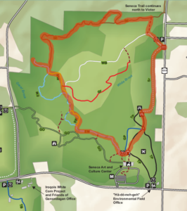
This Sunday, Springwater Trails will return to the trails of Ganondagan State Historic Site at 7000 County Rd. 41, Victor, NY. This is a favorite location for hiking with trails contributed by the Friends of Ganondagan and by .Victor Hiking Trails.

Here’s a bit of the history of Ganondagan:

Ganondagan also known as Boughton Hill, is a Native American historic site in Ontario County.  It is the location of the largest Seneca village of the 17th century. At one time the community consisted of 150 bark longhouses and an estimated population of 4,500. his site is at the center of the story of the Peacemaker, who unified the five major peoples and created the Haudenosaunee confederacy, which survives to this day.

On June 13th 1687, 832 colonial regulars, 900 Canadian militia, and some 400 Indian allies arrived at Ganondagan to eliminate the Seneca competitors in the international fur trade.  The Canadian led troops  were attacked by 450 – 800 Senecas, but after a short engagement the Senecas fled to Cayuga and later resettled in Canandaigua.

We will decide the details of the hike when everyone arrives. Options include the Seneca and Dryer trails, The Earth is our Mother Trail and the Trail of Peace. These trails include both wooded and open grass areas, plus flat and hilly terrain.


The Meeting Place

A Ganondagan parking lot at (42.961511736583894, -77.41544238309267)


The Social

The social will be at Cheap Charlies: 8 Elm St., Bloomfield, NY


Directions 

Can be easily found using GPS

From Springwater and South – Take Route 15A north Just past the green dollar store in Hemlock make a right onto 20A.  Make a left onto County Rd. 37 just before the Valley Inn on the corner.  Take County Rd. 37.  Continuing straight it will become Rt. 65, then W. Bloomfield Rd. (CR-35).  You will turn right onto Boughton Hill Rd. (CR-53 which becomes 41) Make a left into the parking lot.

From Rochester, take I-490 to the Victor exit, then Route 96 to Victor. At the third traffic light in the center of Victor, turn right onto Maple Avenue (State Route 444). At the top of the hill (stop sign/red light), turn right onto County Road 41 (Boughton Hill Road). The Seneca Art & Culture Center is down the hill on your right. The entrance to visitor parking is the third driveway on the right.

Directions to Cheap Charlies

5 minute trip – Make a  left out of the parking lot onto Boughton Hill Rd.  At the blinking light, make a right onto State Route 444. Continue straight, Cheap Charlies will be on the left as you approach Bloomfield.

Posted on by

Harriet Hollister Spencer Recreation Area, Springwater-Hike

Harriet Hollister Spencer State ...

Please join us this Sunday for one of our favorite hikes not far from Springwater!

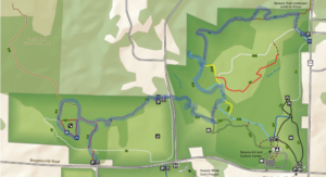
A few years ago New York State acquired several new parcels of land to the south of Harriet Hollister Spencer Park, linked to the main park by an established snowmobile trail called C4. In the past, we’ve hiked the section of the C4 trail closest to the main park, and this Sunday we will hike from the parking lot, following Ruthies trail, to Chalet trail  to C4  trail. We will follow C4 to a point where we will turn onto a old single track hiking trail (red dashed) that crosses  the “Sidewinder” trail through the south east section of the park. we’ll follow this around and return back to the parking lot via the  single track trail  (red dash trail) which runs parallel with the overlook road.

Wear proper clothing according to prevailing weather conditions . As always, bring water, poles, and good hiking footwear. The trail is gently rolling – no especially steep sections.

Optional Social: Please join us at the Birdhouse Brewing Company in Honeoye – 8716 Main Street, just east of the traffic light, for craft beer and pub food

Directions:  

From Springwater and Wayland – take Route 15A North from Springwater, turning right on Wheaton Hill Road. Take a left on Canadice Road (County Road 42), forking to the right when County Road 42 divides off from Canadice Lake Road. Make the next right, on Tibbals Road (formerly Town Line Road). In 1.0 miles, Take the first left onto Ross Rd. At the stop sign (2.7 miles), take a sharp right onto Canadice Hill Rd. The parking lot will be on the left in 0.8 miles..

From Rochester or Canandaigua – go to Honeoye, and follow Route 21A (Main St. Honeoye) west toward Hemlock. About a mile out of Honeoye turn left on County Road 37. Follow County Road 37 until it makes a 90 degrees turn to the right across from the Canadice Methodist Church; at this point go straight onto Canadice Hill Road instead of County Road 37. Continue straight on Canadice Hill Road, taking the left fork at Ross Road, The parking lot will be on the left in 0.8 miles..