 This Sunday, we return to Stony Brook State Park, south of Dansville. Being it’s a state park, we won’t be competing with hunters, who might mistake you for a deer, wearing a bright orange cap and jacket. This park features a fairly steep trail up a beautiful gorge, with 3 waterfalls and surrounding forests.
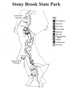
I have received word that they are no longer collecting an admission charge. Therefore, we can meet at the parking lot at the first (north) entrance. From Springwater, take 390 to exit 4 and turn right, going south on 36. Park entrance is on your left.

Their most scenic trail is the one that follows the gorge, passing the 3 waterfalls. This trail can be treacherous when icy and is, therefore, closed in the winter. Next Sunday, it may, or may not, be open. If it’s open, we will take this trail to the top, and descend down the west rim trail, through the late autumn forest. If it’s closed, we can ascend by the east rim trail. Total is about 2 miles. Those, who would like to hike longer can go halfway up the east rim trail, and back, adding another mile. Those, who would prefer to not make the steep climb up the gorge, can carpool to the south entrance parking lot and hike down the gorge or west rim trail.
After the hike, those, who would like, can enjoy the fellowship and fine fare at the Sunrise Restaurant in Dansville. Turn right, out of the park entrance, going north on 36. Go straight across Main St, 1 more block, and turn left. Go 1 & 1/2 blocks to the large parking lot in back of the Sunrise, on your left.
See you there. Put in your order for a sunny and crisp November day.
Directions: Click here for detailed directions. Take I390 to Dansville, NY, Exit 4. At the end of the exit, turn right on Rt 36S. The park is on the left, less than 2 miles south. Follow the park road to the parking lot.
For Google directions, click here.
On your GPS use 42.526417,-77.696533 as your destination.


