.[nggallery id=1 template=carousel]
Monthly Archives: December 2012
Rob’s Trail and Canadice
[slideshow id=1]
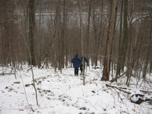
Our hike from Canadice up to Rob’s trail was a relaxing hike in preparation for the winter to come. Although Canadice Lake shows more evidence of the glaciers, this was not a geological hike like Mendon Ponds. Ralph and I noted that if the Glacier was a mile thick, then the top of the ice would have been nice times higher than Bald Hill. After that small discussion, we reverted to more important topics such as what time the hunting season ended, and how to dry firewood.
Rob’s Trail at the top of Bald Hill circles an old field. This is a good place to study how a field turns into a forest. Most of the trees and bushes in this area a small. The trail borders the top of the DEC state forest above Canadice. Continue reading
Rob’s Trail – December 9, 2012 at 2:00PM
This Sunday, the Springwater Trails hiking group is returning to a familiar hike on Rob’s Trail to Canadice Lake. This is the last day of the regular hunting season, so bright orange clothing is still appropriate. However, we think most hunters will avoid this trail.
Please note that trail work at Wheaton Hill has been postponed until Dec 30th.
Join us for a hike to Canadice Lake before the snow falls. If you haven’t hiked Rob’s Trail with all of the leaves gone, come see how much different things look.
After the hike, we will meet at the Hemlock Grill for an after hike social. Continue reading
Rob’s Trail parking lot to the Canadice Lake trail head South – Directions
If you plan to hike from Rob’s Trail down to Canadice Lake and exit at the south end, use these directions to drive to the pickup point.
Turn left out of the Rob’s Trail parking lot. Proceed south on Old Bald Hill Rd. Just before the intersection with Rt 15A, turn left on Johnson Hill Rd. Take the first left onto Canadice Lake Rd. Park at the trail head 1.1 miles north on Canadice Lake Rd.

