Posted on by

Hike out of 2018

Please join us on the last Sunday of 2018 for a hike on the Springwater Trail at Pardee Hollow, followed by our holiday social at John’s house. Bring you extra cookies and a dish to pass (or make a contribution to the social fund) and a beverage and join us at John’s for some good conversation and some music – you will be welcome to contribute your own rendition of favorite holiday tunes.

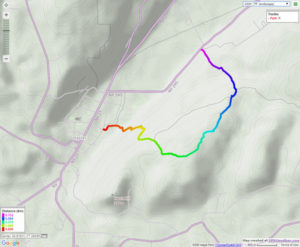
We will meet at the entrance to the Springwater Trail on Pardee Hollow.  Lets park on the right hand side heading down hill from the Sugar Shack. The Tourists and Naturalists will carpool up Coates Rd to the seasonal entrance to the trail.  They will follow the orange access trail into the blue trail, then turn left and climb to the fields at the top of the hill to enjoy the views. After walking the fields, head back down the blue trail to the cars on Pardee Hollow. Climbers will hike up the blue trail from Pardee Hollow, to the fields at the top.  We will then explore the Trillium Trail and head back down the way we came up. This will include more climbing than the Tourist route.

Linda and I did a pre=hike on Friday and the temperature was around 50 and the trail had many slippery leaves to watch for. Sunday is predicted to be  at or below freezing, so conditions may change. Poles are recommended and possibly traction devices on your feet, although they may quickly become clogged with leaves. Dress in layers so you can cool down on the way up and bundle up on the way down.

Directions: Please click here for directions,

Posted on by

Hi Tor

This week we return to HiTor WMA above Naples. All hikers will meet at the parking area on Dewolf Rd. (A on the map below – click on the map to see a bigger version). Poles and good tread are recommended. There, we will break into our 3 groups.
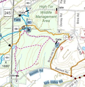
 The Climbers: Carpool to DEC entrance at Donley/Shay and Parish Rd (B). The initial entry is a grassy laneway that meets up with the blue trail near Conklin Gully. At the next trail intersection hikers will bear left onto the orange trail ascending to Brink Hill Rd. Once on Brink, turn left and follow the road to the stop sign, turn right, uphill to the end of Dewolf.

The Tourists will follow the FLT orange trail (C) on Brink Hill Rd to the blue trail on the grassy access road. We will then turn right and follow the access road along the edge of Parish Gully to the parking area on NY-245 near the intersection with Parish Hill Rd. Cars will be available to transport the tourists back up to their cars and the social. This hike is mostly downhill.

The Naturalists will enter High Tor 0.2 mile south of access 7, on a DEC access road (D). There is a For Sale sign on the property across from the DEC parking area. This hike will be an out and back, allowing the Naturalists to adjust the length of the hike to meet the wishes of the hikers.  The road continues straight though the first intersection. At the second intersection, the naturalists should turn right to come to the lean-to and enjoy a long view of Canandaigua Lake. Bring your binoculars for Bird and duck spotting on the 2 ponds. From the lake view , turn around and follow the same road back to the cars.

Following the hike, join us for a social at Amy’s. The main dish will be provided. Please bring a dish to pass and your own beverage (or make a small $5 contribution to the social fund)

Directions from Naples:

From Naples/ Main St. travel SOUTH to join Rt. 53S, up the hill, away from town. Turn LEFT on Yates County Rd #21/ Italy Valley. Turn LEFT at the curve onto Bassett Rd. Church on opposite corner. Turn LEFT on Brink Hill Rd. Turn right onto Dewolf Rd at the stop sign. Follow the road to the top of the hill (A).

We need someone to meet Amy at the Parish Hill parking area on Rt. 245 @ 1:30pm to leave a vehicle for the tourist’s return. Please comment or email Amy if you can do this. Thanks!
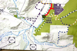
Note: An alternate route is possible from Rt 245 following Parish Hill Rd. Bear right at the curve to stay on Parish Hill then left on Shay Rd, first right on Brink Rd which turns into Dewolf Rd.  A large portion of Parish Hill Rd is still dirt so the Bassett route is easier.

Posted on by

The Finger Lakes Trail from Naples to Conklin Gully

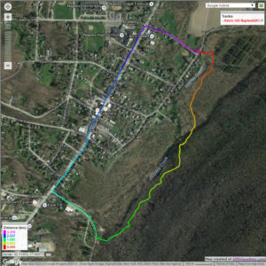
The Sunday hike on October 14th 2018 will cover several trails on Hatch Hill in Naples; the Fall colors should be at the finest for this hike.  The hike will start at the Bob North bridge at the bottom of Ontario Street in Naples. There is a kiosk and a small parking lot there, and all groups will start at the same place. The Naturalists will walk along Matt’s Meander to the Naples Community Park and back, while the Tourist will walk south along Hatch Hill above the town to the south end of Naples. The Climbers will walk north on Hatch Hill to Conklin Gully. Both Tourists and Naturalists will walk back to the parking lot, while climbers will end up at the DEC parking area at the bottom of Conklin Gully and be shuttled back to Naples. Note: the last half mile of this hike is a very steep downhill, but it’s worth it; the are huge drops into the gully to the right of the trail, and wonderful view across the gully and down into it.

There is a DEC display board at the parking lot with a map of all the trails that meet there; all the day’s hiking trails are shown.

The social will take place at the Neapolitan Pizzeria in downtown Naples.

NaturalistsNaturalists at Hi Tor

The Naturalists will cross Naples Creek on the Bob North bridge and bear to the left. It is a broad path through woods with the Naples Creek flowing to the left of the path. This trail is called “Matt’s Meander”, and it follows Naples Creek to the Community Park on Route 245. It is about a mile to the end of the trail and back.

Tourists

The tourists will cross the bridge and bear to the right. The trail runs south along Hatch Hill above Naples Creek, and goes parallel to both Naples Creek and Naples Main Street, though a lot higher up the hill. This path is not blazed or marked at all but it is well trodden for most of the way; it becomes a little harder to see at the southern end, but once the Turkey Federation parking lot is in sight then it’s not hard to find a way down to it. The trail passes through land that was once grazed and then terraced for vines, but is now returning to woodland. Traces of the shallow terracing for the vineyards can be seen all along the trail, and occasionally an abandoned farm building. The creek can be seen in the valley below the trail all the way along. This trail ends at the south end of Naples, on Mark Circle, where several streams come together to form the Naples Creek. There is water supply facility there, a swimming hole, and an antiques shop. The group will return to the Ontario Street parking lot via Naples Main Street. This walk is 2.1 miles. with just one short modestly steep section.

Climbersnaplesclimbersweb2

The Climbers will take the Finger Lakes Trail to Conklin Gully through the High Tor Game Management Area. They will cross the bridge and bear left along with the naturalists, and then about half way down Matt’s Meander the FLT branches off to the right. The group will follow the ORANGE blazes on a long uphill section; it’s steep in places with some switchbacks – the trail seems to be going the wrong way at times. There are some ponds at the top of the hill (it’s a mystery – where does that water come from?) with the Howard Beye memorial bench on one of them. It’s important to stay with the orange blazes here – there are several logging roads that make it easy to take the wrong path. Where the trail meets the top of Conklin Gully there is a lookout with a fine view of the Naples Valley and a well organized scout camp, complete with fire pit. The path down the hill from the camp is broad and easy walking. The group will leave the FLT where it branches off to the right over a bridge to the memory of Tom Noteware and follow the BLUE blazes down the hill to the DEC parking lot at the bottom of Parrish Hill.


The Meeting Place

We will meet at the trail head parking lot on Ontario Street, Naples, at 2:00pm on October 14th 2018. The climbers will shuttle some cars to Parrish Hill before starting off.

Getting There

From Springwater and Wayland, come south on Rt. 15 to the traffic light at Rt 21. Turn left on 21 and keep going all the way to Naples. Go through the downtown business area and turn right on Ontario Street, opposite the school. Go to the bottom of the hill and the parking lot is on the left.

From Dansville, follow Rt. 63 to Wayland where the road turns into Rt 21; continue on 21 all the way to Naples. Go through the downtown business area and turn right on Ontario Street, opposite the school. Go to the bottom of the hill and the parking lot is on the left.

From Naples, go to the school on Main Street (Rt. 21). Turn down Ontario Street opposite the school, go to the bottom of the hill and the parking lot is on the left.


The Social

The social will take place at the Neapolitan Pizzeria in downtown Naples.

Posted on by

Canadice Tri-Modal

This Sunday, Springwater Trails is hosting the fifth annual tri-modal hike around Canadice Lake. Bring your bike, your kayak and walking shoes and celebrate one of the two undeveloped Finger Lakes. Canadice Lake is unique among the Finger Lakes with a road and trail around the entire lake at water level. We will enjoy this trail on Sunday on foot and bicycle, and will add in some kayaking to complete the tri-modal event.

There are four hikes planned, depending on the interests of the participants.

Tri-modal: We will start on our bikes, traveling north from the Canoe Launch along Canadice Lake Rd. At the north west corner of the lake, we will enter the trail and continue around the lake, returning to the Canoe Launch.  From there, it will be a short kayak across the lake, where we will leave our boats and hike north on the trail, planning to turn around at the Rob’s Trail bridge. Finally, we will return across the lake in our boats.

Bi-modal Climbers: The climbers will start in kayaks and spend about an hour on the lake, ending at the west side of the lake. They will beach their boats, leaving their paddles and life jackets in the boats, and turn left on the trail to hike around the south end of the lake and back to the Canoe Launch.

Bi-modal Tourists: The tourists will do the reverse hike of the climbers. They will carpool with the Naturalists to the south end of the lake, and then hike in to where the Climbers have left their boats.  This hike will be slightly more than an hour, giving time to check the fall flowers near the trail. The Tourists will use the Climber’s kayaks to return across the lake to the Canoe Launch.

Naturalist Hikers: Hikers are invited to join the Naturalists for a hike along the Canadice Trail. Hikers will carpool to the southern entrance to the trail, and will hike for one hour, and then turn around and return to the cars and the Canoe Launch.

Following the hike, join us for a pot luck social at the Canoe Launch. We will grill hot-dogs. Please bring a dish to pass and your own beverage or make a donation to the social fund. 

NOTE: Some of you may have noted that our plans depend on equal numbers of Climbers and Tourists. This may require some flexibility on your part and adjustments on the precise routes.

So, dust off your bike, load up your car and come enjoy a sunny fall afternoon on Canadice Lake.

Directions: All participants should meet at the Canoe Launch near the south end of Canadice Lake. Please arrive early enough to unload your boat and bike and stage them for the start of the event. 

NOTE: the Canoe Launch is 1.5 miles south of the motor boat launch site.

From Springwater: Purcell Hill access: Go North on 15A for 7.6 miles.  Turn right on Purcell Hill.  At the end of Purcell Hill Rd, turn right onto Canadice Lake Rd on the east side of the lake.  The Canoe Launch is 2.9 miles south.

From SpringwaterJohnson Hill access: Go North on 15A for 2.7 miles. Bear right on Old Bald Hill Rd S and then an immediate right on Johnson Hill Rd. Take the first left onto Canadice Lake Rd. The Canadice Canoe Launch is 1.8 miles north of Johnson Hill Rd.

From Honeoye: Take Co Rd 37 South from 20A, Turn right after 3.7mi to stay on Co Rd 37. Stay straight onto Burch Hill Rd. At the lake, turn left onto Canadice Lake Rd. The Canadice Canoe Launch is 2.1 miles south of Burch Hill Rd.

From Hemlock and Rochester: Take NY Rt 15A south from Rochester through Lima and Hemlock.  Just past Hemlock, Rt 20A  goes left.  Continue straight on 15A for 3,2 miles after 20A.  Turn left on Purcell Hill.  At the end of Purcell Hill Rd, turn right onto Canadice Lake Rd on the east side of the lake.  The Canoe Launch is 2.9 miles south.

Please obey the No Parking signs at the launch area.