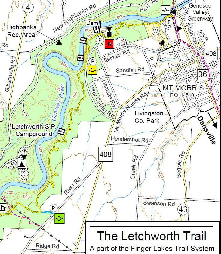
This month, our third hike in our Letchworth Series covers a relatively short section of the trail from Access D to Access E. The main trail is just 2.3 miles with 0.6 miles of access trail since we will park on the road. There as several park trails to views of the river which will afford us opportunities to adjust the route to accommodate hikes of different lengths.
Since this is a through hike, all hikers will meet at the southern end, Access E. From there, we will car pool back to Access D, in the Naturalists cars (an others if needed), leaving cars are Access E to pick up the Climbers and Tourists at the end of the hike.
All hikers will begin hiking at Access D. The Climbers will follow the blue access trail west to the main trail and then will turn left (south) on the main yellow blazed trail. In 0.7 miles we will cross under power lines, and in another 500 feet we will cross the Letchworth State Park trail #21. The climbers will turn right and follow LSP-21 to an excellent overlook of the river. After John has an opportunity to record the river on his camera, we will return on LSP-21 to the main trail and turn right to continue south. Look for a shelter on the right in 0.1 miles and a couple of crossings of LSP-16 in a mile. Most importantly watch for the Blue access trail. Turn left on the access trail and travel 0.4 miles to the cars at Access E. Total trip is 3.5 miles.
The Tourists will follow the Climbers but will stay on the main trail for a 2.9 mile trip. When the tourists reach LSP-16 (2 miles into the hike), they can check their watches and choose to explore LSP-16 if time permits. This trail goes to the right for 0.4 miles to a river overlook (and 0.4 miles back to the trail). Finally, continue south on the main trail for a half mile to the Blue access trail. It is 0.4 miles out to the cars at Access E. Total trip without exploring LSP-16 is 2.9 miles.
The Naturalists will also follow the Climbers and Tourists down the Blue access trail, then left onto the main trail. After passing under the power lines, watch for the LSP-21 trail. The Naturalists will turn left on the LSP-21 trail (away from the river) and follow that trail for 0.7 miles back to River Rd. Again, turn left on River Rd for about a quarter mile road walk back to the cars at Access D. Total loop is about 2.0 miles.
Following the hike, join us for an optional social at the Sunrise restaurant in Dansville.
Directions:
A self serve carpool will meet at 1:05 at the municipal parking lot behind the Wayland Fire Department off NY-63 in Wayland. Car pooling will leave promptly at 1:15.
From the carpool meeting spot: leave the parking lot to the south along the side of the Fire Department. Turn left onto NY 63, then right on NY-15S. In 2 miles, turn right onto I-390. Take exit 6 to NY-36 Mt Morris. Turn left onto NY-36. Continue past the Correctional Facility and take the 2nd left onto Dutch Street Rd. In 1.3 miles, turn right onto Ridge Rd. At the end turn left onto River Rd. The parking area is on the right.
From Springwater: Head south on NY-15 through Wayland. Turn right onto I-390. Take exit 6 to NY-36 Mt Morris. Turn left onto NY-36. Continue past the Correctional Facility and take the 2nd left onto Dutch Street Rd. In 1.3 miles, turn right onto Ridge Rd. At the end turn left onto River Rd. The parking area is on the right.
From Geneseo: Head out of Geneseo on US-20A West (South St). Continue straight onto NY-63. Continue straight onto NY-408 into Mt Morris. Turn left onto Main St, the right to stay of NY-408. Go past Visitor Center Rd, then turn slight right onto River Rd. In about 2 miles, continue past Ridge Rd. Then the parking lot will be on the right.
To the social at the Sunrise Restaurant: Follow River Rd north to the end. Turn left onto NY-208. At the light in Mt Morris, turn right onto NY 36. In 5 miles, turn right onto I-390. Take the Exit 5. Turn left to go under the expressway, then right onto NY-36. Turn left on Main St, and the Sunrise will be on the right. There is parking out back.
NOTE: The December hike from Access E to Access F is about 5 miles and will be held December 16th, a day when the sun sets at so we will need to start an hour earlier. If there is a lot of snow on the ground, we will need to skip this long section, so please keep your eyes on this page the week before the hike.


