Posted on by

Canadice Lake Paddle and Hike

Please Note:  PURCELL HILL ROAD CLOSURE.  Due to construction of a new culvert from Canadice Lake under Purcell Hill Road, Purcell Hill Road is closed from the North Parking Lot trail entrance to Canadice Lake Road.  The north parking lot is open but may only be accessed from Rt. 15A side of Purcell Hill Road.

The sun will be out and Canadice Lake will be gorgeous.  This week will be a choice of a paddle or a walk around Canadice Lake.  Read below for driving directions to both events.
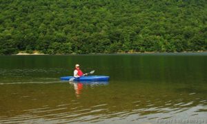
Kayakers:  Please meet at 3:45 to unload boats and be in the water by 4:00. We will paddle across the lake, selecting a route based on wind and interest of the group.

Hikers: Meet at the canoe launch to select leaders and drivers to the South hiking path.

Naturalists: will walk the road around the lake observing the marsh land on the south side of the lake and the activity of the beavers on the southwestern corner of the lake.

Climbers: will hike along the lake to join Rob’s trail hiking up a portion of the trail then turn around and return to the trail head.

Social:  The social will be held by the lake at the canoe launch.  A table and paper products will be provided.  You may wish to bring a chair to sit on at the social.  There is one bench available at the site.

If you do not own a kayak, you can test the waters by renting one from Canadice Lake Outfitters at a very reasonable rate.

Rates are $20 for 2 hours; $40 for 4 hours   Click here for better information. Reservations must be made in advance.  Call: ( 585) 669-9512

Directions to the Hike:

Please Note:  PURCELL HILL ROAD CLOSURE.  Due to construction of a new culvert from Canadice Lake under Purcell Hill Road, Purcell Hill Road is closed from the North Parking Lot trail entrance to Canadice Lake Road.  The North parking lot is open but may only be accessed from Rt. 15A side of Purcell Hill Road.

From Springwater: Johnson Hill access: Go North on 15A for 2.7 miles. Bear right on Old Bald Hill Rd S and then an immediate right on Johnson Hill Rd. Take the first left onto Canadice Lake Rd. The Trail-head is 1.1 miles north of Johnson Hill Rd.

From Honeoye: Take Co Rd 37 South from 20A, Turn right after 3.7mi to stay on Co Rd 37. Stay straight onto Burch Hill Rd. At the lake, turn left onto Canadice Lake Rd. The Trail-head is 2.8 miles south of Burch Hill Rd.

From Hemlock and Rochester: (This route avoids the construction) Take NY Rt 15A south from Rochester through Lima and Hemlock.  Just past Hemlock, Turn left on Rt 20A. In 1.4 miles, turn right onto Canadice Lake Rd.  The Canoe Launch is 6.3 miles south on the right side of the road near the south end of the lake. Note, you will pass the motor boat launch near the north end of the lake. The canoe launch is another 1.5 miles south.

Posted on by

Naples/Tannery Creeks/Grimes Glen

42.617844, -77.396354 (Ontario St. Parking Lot)              

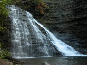
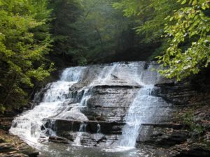
This Sunday we will hike trails on the outskirts of the Village of Naples. The first is the Naples Creek Trail, which follows the eastern edge of Naples Creek within the Hi Tor Wildlife Management Area. The second is Grimes Glen Park, a spectacular glen on the west side of the village. And for the more adventurous, the Tannery Creek Falls which features a number of waterfalls and cascades. These trails offer splendid creek-side scenery.

Tannery Creek Falls: Not as well known, or as large as its more famous companion Grimes Glen, it is another glen that is well worth the visit. Unlike Grimes Glen, there are no signs for this glen, so it gets much less traffic. Walking up the creek you will pass a couple of 10′ high falls before reaching a bigger 15′ falls. Above this is a much higher two tiered falls, around 50′ high. The trail requires some scrambling, steep ascents, and creek crossings. It is recommended that your footwear has good traction because the shale in the creek bed is very slippery. The rock walls along the creek are steep, varied, and beautiful.

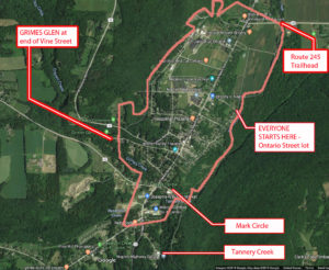
1)  We will need at least 4 or 5 drivers to meet at 3:35 to drop off some ‘transport’ vehicles at the Mark Circle parking lot:           42.608848 -77.403133 (Mark Circle)

Drivers will then carpool 1 mile to meet the rest of the arrivals at Ontario Street(see below). If you can be part of the transport team, please leave a comment below.

2)  All hikers will then meet @ 3:45 at the parking area at the bottom of Ontario Street for check-in, maps, hiking instructions, and directions to the social.

3)  We will begin the hike by crossing the bridge over Naples Creek, where we will then split up.

 Naturalists will hike north along the level and picturesque Naples Creek to Rt 245, then return to starting point for a total of approximately 1.5 miles. Following this, the naturalists may wish to drive south .4 miles on Main St; turning right onto Vine Street. Grimes Glen is at the end of this street. There is a nice trail of about ½ mile to the waterfalls.

Climbers and Tourists will head south along Naples Creek for .8 miles to Mark Circle. This trail is mostly level except for a moderate climb and descent in the southern half. If there has been recent rain, there will be muddy patches.

Climbers will then carpool approx. ¾ of a mile by going back up to Main St., turning left, and continuing along S. Main Street past Joseph’s Farm stand and the Hardware store on your left. Stay on Rt 53 past the Rt 21 intersection for about 175 yards and turn left onto Tannery Creek Rd. Parking for the Tannery Creek Falls is on the right, across from the highway dept building (look for the green sign).

The trail to the creek is accessed by walking between the two buildings. Go down the bank to the creek. Cross it and continue upstream on the left side. It is necessary to cross over to the right side before climbing to the high, two-tiered falls. There are ropes provided for the steepest ascents.

Tourists will then carpool approx. ¾ of a mile from Mark Circle to Grimes Glen. To get there, from Main Street turn right and take the first left onto Weld Street. Go to the end and turn left onto Vine St., which will take you into Grimes Glen. It is a short ½ mile hike up to the falls and back.

Following the hike, please join us for an optional social at John & Susan’s (directions available at the start of the hike). Please bring a dish to pass (or make a $5 donation to the social fund), a beverage of your choice, and any musical instruments you might want to play around a campfire. Hotdogs, marshmallows, and ice-cream will be provided!

 DIRECTIONS   to Ontario St. parking lot   https://goo.gl/maps/TbNWrqUSkZsr2E4Z

 Drive up to Main St and turn right. In .67 miles, turn right onto Ontario Street. Drive down to the bottom and park on the left.

  • From Springwater/Dansville/Wayland: Take Rt 21N into Naples, turning to the left at the intersection with Rt 53. Turn right in about .9 miles down Main Street onto Ontario St (across from the High School) and drive down to the parking area.
  • From Honeoye: Take Rt #36 South into Naples, turn left on Main St an drive .7 miles and turn right onto Ontario St. Go down to the bottom parking lot on the left.
  • From Canandaigua: Take Rt 21 South to Naples. From the intersection with Rt 245, drive approximately .5 miles along Main St. and turn left onto Ontario St. Go down to the parking area on the left at the bottom.

See 1) above for directions to Mark Circle – this is for transport vehicles only

Posted on by

Dryer Road Park and Ganondagan

CHANGE OF VENUE FROM THE EARLIER PUBLISHED HIKE:  This Sunday we will be hiking in and around Ganondagan State Historic Site in Victor, with initial meeting and a pot-luck social at nearby Dryer Road Park. The three groups will have hikes ranging from 2 to 5.2 miles, all including the Grainary section of Ganondagan and its overlooks to the south toward the Bristol Hills. Trails are generally well maintained and gentle in slope, with a few uphill sections. Bring bug spray, wear long pants for tick control, and bring poles if you are used to hiking with them.

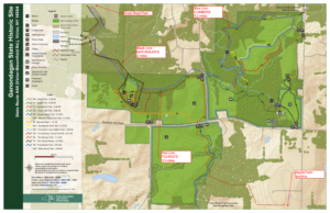
Map of Naturalists, Tourists and Climbers hikes at Ganondagan.Ganondagan is the site of a large 17th century Seneca town, and offers hiking trails with interpretive markers illustrating the history and traditions of the Seneca people. The trails will take us through wooded rolling hills and meadows just south of the Village of Victor. Highlights will include the Granary Trail, where the Senecas protected and distributed their corn supplies on a palisaded mesa, and part of the Earth is Our Mother Trail, where interpretive markers describe local plants and their particular roles in Seneca life.   Portions of the hikes will be in the Town of Victor’s Dryer Road Park, adjacent to the Fort Hill (Granary) portion of Ganondagan, and one hike will include a beautiful section of Victor Hiking Trails’ Seneca Trail, adjacent to Great Brook and its Beaver Pond.

All hikers meet at 3:45 at Dryer Road Park, 7405 Dryer Road, about 1 mile west of Route 444 and Dryer Road or 1.5 miles east of Malone Road in the Village of Victor. From there, Climbers and Naturalists will follow the Victor Hiking Trails pathway up the hill, past an open clearing and through a mature hardwood forest. Mountain bikers will know this area for its dense pattern of bike trails off to the sides of the main walking path. The trail leads to the open mesa at Fort Hill, where the circular Granary Trail offers expansive views as far as Bare Hill, and where interpretive markers describe Seneca life and history, their use of the protected mesa, and the conquest and destruction of Ganondagan during the 1687 Denonville Raid.  Naturalists will circle the Grainary Trail and the open clearing and return to Dryer Road Park for a total hike of about 2 miles.

From the Granary Trail, Climbers will head east down the Eagle Trail, through more beautiful hardwood forest and across School Street to the Ganondagan village site and surrounding woods and fields. This group will explore the Seneca Trail and Grasslands Trail, looping through the hardwood forest and then an open meadow, returning to the Grainary area and Dryer Road Park for a total hike of about 5.2 miles.

Tourists will leave their dish to pass in someone else’s car at Dryer Road, then drive/car pool to the Apple Farm at 1640 Route 444, Victor. Park near the retail store to the rear of the main house. We will then hike west through the back lands of the Apple Farm to the Seneca Trail and head north along Great Brook to Boughton Hill Road. Crossing the road to the Ganondagan lands, we will head north next to School Street and turn west into the woods and up the hill to the Grainary Trail and the scenic overlook to the south. After looping around the Grainary, we will re-enter the woods into Dryer Road Park and back to the cars.  Tourists will be driven to retrieve their cars at the Apple Farm at the conclusion of the social.

Please join us for a dish-to-pass social (optional) at the picnic pavilion at Dryer Road Park. Bring something delicious and nutritious, or make a contribution to our refreshments fund. BYO beverage.

Directions:

From Springwater/Honeoye area: Go north to Honeoye and then east on 20A to Route 64.  Go north on 64 for 3.7 miles to the 5 and 20 intersection. Go west on 5 and 20 for 1.25 miles and make a right on Route 444 (Maple Ave.).  Proceed 6.2 miles to Dryer Road (bottom of the hill, past the flashing light).  Turn left at Dryer Road and go 1.4 miles to the entrance to Dryer Road Park, on your left. If you come to Malone Road, you have gone too far.

From points east:  Take 5 and 20 west toward Bloomfield. Go right at the Route 444 intersection, and proceed 6.2 miles north to make a left on Dryer Road. Go 1.4 miles to the entrance to Dryer Road Park, on your left. If you come to Malone Road, you have gone too far.

From Rochester:  Take Route 64 South from Pittsford to Mendon, and go east on Route 251 at the town center. In 1.5 miles make a right on Strong Road and then in 1.5 miles a left on Dryer Road. Dryer Road Park will be on the right in 1.6 miles.

Posted on by

CHANGE OF VENUE: Onanda Park Stream Hike, plus optional bike ride or Quiet Meadows

For our June 23 event hike we will revisit Onanda Park, on the west shore of Canandaigua Lake (4965 County Road 16), for the summer solstice experience – hikes in the woods and in the streambed, with a West Lake Road cycling option and an optional side trip to the nearby Quiet Meadows wildlife and meditation sanctuary.

Meet at the parking lot on the west (Uplands) side of County Road 16 (a.k.a West Lake Road) at 3:45. We will divide into three groups: Cyclists, Naturalists/Meditators, and Wet Feet Hikers. Cyclists and Naturalists/Meditators may time their activities so that they get in some wet feet hiking during the second half of the event.


Cyclists will head north on West Lake Road for approximately 5.25 miles to the Yacht Club, then return, for a total of 10.5 miles, or choose  a longer route if they wish. West Lake Road is a good cycling route, with paved shoulders averaging 4′ and a 35 MPH speed limit. There are two moderate climbs each way, but much of the route is at lake level. After returning to the starting point, Cyclists may cool off with a hike up the creekbed and back (bring a change of shoes).

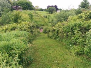
Naturalists/Meditators will car pool about 1.1 miles to The Quiet Meadows, at 5787 Barnes Road. The Quiet Meadows is a Certified Wildlife Habitat and a private  outdoor sanctuary for meditation. It is not a recreation site, but is intended for quiet contemplation and appreciation of nature. The 5 acre property includes a grass labrynth  and a network of mowed grass paths and bridges through shrubs, grasslands and wetlands. As the owners explain at their web site, “visitors are encouraged to walk the paths and the labrynth, sit on the benches for quiet repose, prayer and reflection and take away with you some of the stillness of the hills.”  This is a particularly beautiful time of year in the meadows, with many wildflowers and flowering shrubs in bloom.  You may want to revisit this site many times for its outstanding sense of peace. See https://www.quietmeadows.org/about.html for more about Quiet Meadows and the tradition of the labrynth. After the session at the Quiet Meadows, the Naturalists/Meditators will return to Onanda Park to cool down with a short hike up the creekbed (bring a change of shoes).

Climbers, a.k.a. Wet Feet Hikers, will explore a different section of Onanda Park from the trails we saw in the snow last March. We will start off on the South Rim Trail (about .75 miles), then head up the creekbed of Barnes Gully and back, passing through the culvert under West Lake Road and down to the mouth of the creek at the lake for some stone skipping. The creek hike is not a town-sanctioned trail, but walking in it is not prohibited, and there are well traveled paths along one side or the other across most of the length. Getting between them requires going through the stream, so expect to get your feet wet. Water sandals or old sneakers with good treads are recommended. The water level will be up to ankle height in most places. We will encounter a series of waterfalls of increasing difficulty, and will keep going until we reach the chicken-out point. Estimated creekbed hiking distance, including the trip to the lakeshore and back, is about 2.5 miles.


Social – Please join us for a dish-to-pass social in a lakeview pavilion close to the parking area.

Directionsfrom Springwater: Take Route 15 south to Wayland and Route 21 east/north to Naples. Continue through Naples and Woodville. 2.75 north of Woodville, take a right to follow Route 21 north where it splits with 64.  Go another 4.9 miles, then make a right on County Road 16 (a.k.a West Lake Road). Enjoy the panoramic view of the lake.  In 2 miles you will be down near the lake shore. Make a left into the “Uplands Trail Access” entrance to Onanda Park. Park in upper lot. This is free parking and access, unlike the lot on the lake side.

From Rochester and points north/west/east: Head to Routes 5 and 20 via Bloomfield or Canandaigua. About a mile west of the City of Canandaigua, turn south on Route NYS Route 21S.  Go 4.3 miles, through the hamlet of Cheshire. At the south end of Cheshire, just over the hill, take a left on Deuel Road. In 2.2 miles, Deuel Road will end at County Rd 16 (West Lake Road). Make a right and go down the hill for .5 miles. The Onanda Park “Uplands Trail Access” entrance will be on your right. Park in upper lot. This is free parking and access, unlike the lot on the lake side.