
42.617844, -77.396354 (Ontario St. Parking Lot)
This Sunday we will hike trails on the outskirts of the Village of Naples. The first is the Naples Creek Trail, which follows the eastern edge of Naples Creek within the Hi Tor Wildlife Management Area. The second is Grimes Glen Park, a spectacular glen on the west side of the village. And for the more adventurous, the Tannery Creek Falls which features a number of waterfalls and cascades. These trails offer splendid creek-side scenery.
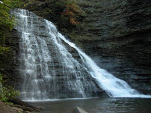
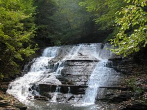
Tannery Creek Falls: Not as well known, or as large as its more famous companion Grimes Glen, it is another glen that is well worth the visit. Unlike Grimes Glen, there are no signs for this glen, so it gets much less traffic. Walking up the creek you will pass a couple of 10′ high falls before reaching a bigger 15′ falls. Above this is a much higher two tiered falls, around 50′ high. The trail requires some scrambling, steep ascents, and creek crossings. It is recommended that your footwear has good traction because the shale in the creek bed is very slippery. The rock walls along the creek are steep, varied, and beautiful.
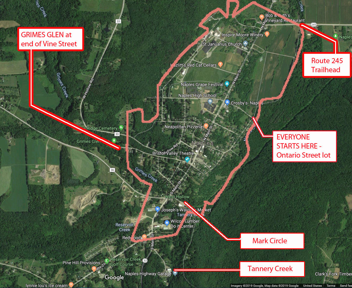
1) We will need at least 4 or 5 drivers to meet at 3:35 to drop off some ‘transport’ vehicles at the Mark Circle parking lot: 42.608848 -77.403133 (Mark Circle)
Drivers will then carpool 1 mile to meet the rest of the arrivals at Ontario Street(see below). If you can be part of the transport team, please leave a comment below.
2) All hikers will then meet @ 3:45 at the parking area at the bottom of Ontario Street for check-in, maps, hiking instructions, and directions to the social.
3) We will begin the hike by crossing the bridge over Naples Creek, where we will then split up.
Naturalists will hike north along the level and picturesque Naples Creek to Rt 245, then return to starting point for a total of approximately 1.5 miles. Following this, the naturalists may wish to drive south .4 miles on Main St; turning right onto Vine Street. Grimes Glen is at the end of this street. There is a nice trail of about ½ mile to the waterfalls.
Climbers and Tourists will head south along Naples Creek for .8 miles to Mark Circle. This trail is mostly level except for a moderate climb and descent in the southern half. If there has been recent rain, there will be muddy patches.
Climbers will then carpool approx. ¾ of a mile by going back up to Main St., turning left, and continuing along S. Main Street past Joseph’s Farm stand and the Hardware store on your left. Stay on Rt 53 past the Rt 21 intersection for about 175 yards and turn left onto Tannery Creek Rd. Parking for the Tannery Creek Falls is on the right, across from the highway dept building (look for the green sign).
The trail to the creek is accessed by walking between the two buildings. Go down the bank to the creek. Cross it and continue upstream on the left side. It is necessary to cross over to the right side before climbing to the high, two-tiered falls. There are ropes provided for the steepest ascents.
Tourists will then carpool approx. ¾ of a mile from Mark Circle to Grimes Glen. To get there, from Main Street turn right and take the first left onto Weld Street. Go to the end and turn left onto Vine St., which will take you into Grimes Glen. It is a short ½ mile hike up to the falls and back.
Following the hike, please join us for an optional social at John & Susan’s (directions available at the start of the hike). Please bring a dish to pass (or make a $5 donation to the social fund), a beverage of your choice, and any musical instruments you might want to play around a campfire. Hotdogs, marshmallows, and ice-cream will be provided!
DIRECTIONS to Ontario St. parking lot https://goo.gl/maps/TbNWrqUSkZsr2E4Z
Drive up to Main St and turn right. In .67 miles, turn right onto Ontario Street. Drive down to the bottom and park on the left.
- From Springwater/Dansville/Wayland: Take Rt 21N into Naples, turning to the left at the intersection with Rt 53. Turn right in about .9 miles down Main Street onto Ontario St (across from the High School) and drive down to the parking area.
- From Honeoye: Take Rt #36 South into Naples, turn left on Main St an drive .7 miles and turn right onto Ontario St. Go down to the bottom parking lot on the left.
- From Canandaigua: Take Rt 21 South to Naples. From the intersection with Rt 245, drive approximately .5 miles along Main St. and turn left onto Ontario St. Go down to the parking area on the left at the bottom.
See 1) above for directions to Mark Circle – this is for transport vehicles only