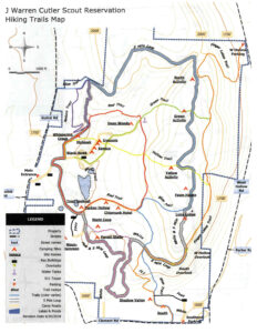
This Sunday we’ll be hiking the trails around Camp Cutler, the scout area between Gulick Road and Hunt Hollow Road in Naples.You can download the trail map from https://springwatertrails.org/wp-content/uploads/2020/08/Camp-Cutler-Trails-791×1024.jpg Here’s what it looks like.
 We’ll meet in the camp; there’s a notice shelter just inside the main entrance off Gulick Road at the edge of a large car park. We’ll divide into 3 groups, climbers, tourists and naturalists. All groups will start off together, walking north from the parking lot.
The trails are well marked with colored blazes except at the beginning, oddly enough! Once the blazes start up the trails are easy to follow, but always look for the next blaze! The trails tend to switch direction sharply, making it easy to wander off and have to double back to find blazes again. The woods are well worn near where the scouts camp and congregate but become thicker and more natural further out. Likewise, the trails are broad and vehicle worn near the entrance, but narrower and grassy at the outer edges of the area.
All groups will start out together following the camp roads. At the first fork, stay to the left at the start of the red trail (no blazes yet). A short distance up the hill, you will see a sign for the Nature Trail. Turn left off the road onto the blazed red trail.
The naturalists will follow the red trail until it separates from the purple trail. They will turn right and keep following the red blazes. They will turn right on the green trail back to the starting point.
The tourists will follow the red trail until it separates from the purple trail. They will turn right and keep following the red blazes all the way back to the starting point.
The climbers will follow the red trail until it separates from the purple trail. They will turn left following the purple blazes north to the blue trail, a well worn 4 wheeler trail. Turn right on the blue trail. all the way around the perimeter of the scout land. In total this is a 5 mile hike; if it’s a hot day, or time is running short there are several trails that cut straight back to the starting point. Each of these cuts take about 30 minutes.

The Social
We’ll have a lunch bag social again. There doesn’t seem to be anywhere comfortable to gather at the scout camp so we’ll go back to the Willow Dome at the Cummings Nature Center. See https://www.willowsvermont.com/diy-structures.html
Directions:
From Honeoye: take route 20A east through Honeoye to East Lake Road (CR 33). Turn right onto East Lake Road. (If coming from Bristol or points east, it’s a left onto East Lake Road). Take the first left, staying on CR 33, then the first right onto Pinewood Hill which becomes Gulick Road. Travel about 7 miles to Camp Cutler on the left side. .
From Springwater: Head north on Rte. 15A toward Hemlock. Just before Hemlock, turn right on Rte. 20A. Follow Rt 20A to Honeoye and then follow the directions above.
From Naples: From the southern end of Naples, head west on Co Rd 36. Follow Co Rd 36 for 1.2 to the first right turn on Gulick Rd. Follow Gulick for about 5 miles. The parking area is on the right.
Directions to the Social from the Trailhead:
Via Gulick Rd: Turn right out of the parking area on Gulick Road. Go about 2 miles to the Cummings Nature Center parking lot on the left. Go to the end of the parking lot, and enter the property on the right. You will see the bench grouping and the willow dome straight ahead.
