Posted on by

Powder Mills Park, Perinton

Powder Mills Park, off Route 96 in the Town of Perinton, is one of Monroe County’s outstanding  hiking parks, matching Mendon Ponds Park for rugged terrain and interesting features. Being inhospitable to farming or development, it was the site of a gunpowder factory in the 19th century, and some vestiges of this history survive, along with stories of some dramatic explosions. The 380 acre property has been a county park since 1930, and features a fish hatchery and a downhill ski area.

Meet at the Wadhams Lodge Parking Lot at 1:50 for a 2 PM start. Warm layers, hiking poles, water and good boots are advised. Hunting is not permitted in the park, so no need for orange outerwear. The Climbers will follow a winding course of about 4 miles of linked trails through the central and east parts of the park, both north and south of Woolston Road. The Tourists and Naturalists will join the Climbers for the first half of their hike, but will make a looped return to Wadhams Lodge after the halfway point, avoiding the most strenuous part of the hike and going about 2.5 to 3 miles.

Afterwards please join us for an outdoor social at the Wadhams Lodge. The Lodge has sheltered picnic tables on a porch and some open grills where we can make a fire to toast our hands at least, if the temperatures warrant it. Bring your own beverage and snacks – hot soup in a thermos will hit the spot, as it will likely be in the 40s. If you have a leftover bag of charcoal, bring that too. We will have some options for food delivery to Wadhams Lodge after the hike (most likely Pizza). More details on this later.

 Directions:
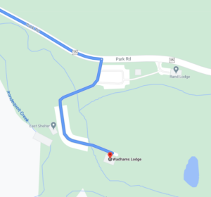
Map inside Powder Mills Park showing Wadhams LodgeFrom Springwater: Head north on 15A for 21.6 miles through Hemlock and Lima. Take a right at the exit to Honeoye Falls. Stay on W Main St into the village , and at the center of town continue straight on Route 65 north.  From Honeoye Falls go north 3 miles to the intersection with Route 251 and take a right (east). Continue east on Route 251 for 1.75 miles and make a left on West Bloomfield Road. After 4 miles and crossing the Thruway, make a right on Thornell Road, then in 1.75 miles a right on East Street and a left on Park Road (the third left). Go about another 0.8 mile into the Park, past several parking areas on the left, and turn in to the Wadhams Lodge parking lot on the right. Bear right and go all the way to the building at the end.   If you come to the Fish Hatchery and Corduroy Road intersection on Park Rad, you have gone too far.

From Honeoye: Go west from the center of Honeoye, and turn north on CR 37. In West Bloomfield, continue straight onto NY 65. On the other side of W Bloomfield, continue straight onto CR 38 (NY 65 turns left). In 9.8 miles, turn right on Thornell Road. In 1.76 miles turn right at the 4-way stop onto East St, then left on Park Road (the third left). Go about another 0.8 mile into the Park, past several parking areas on the left, and turn in to the Wadhams Lodge parking lot on the right. Bear right and go all the way to the building at the end.

By Interstate  490:  Take Route 490 to the Bushnell’s Basin exit. Go left on Route 96, pass the Garnsey Road light, and take a right on Park Road. The Wadhams Lodge Parking Lot will be the third one on the left, past the Mushroom House, the Hatchery Lot, and the Rand Lot.

 

Posted on by

Bully Hill State Forest FLT Hike

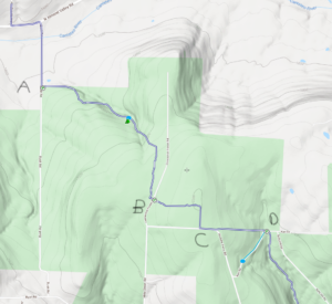
All hikers will start at Access Pt 4 (A) and hike eastward. Based on time, groups will turn around at the three road crossings B, C or D.

Welcome back to the Finger Lakes Trail. This Sunday we will return to the Bully Hill State Forest for a hike on the main Finger Lakes Trail to enjoy another fall hike before the regular hunting season starts.

Note: Bow season is open, so an orange vest and hat are recommended.

All hikers will meet at Access 4 on Bush Rd.  Shoulder parking is available here, just before the seasonal road starts. We will split into three groups based on the desired distance and will do an out and back hike.  On the way back, we will stop at the Bully Hill lean-to for a picnic social (if weather permits). The lean-to is about 3/4 mile from the cars.

This hike is primarily uphill going out, with a total elevation change of 600 feet. The lean-to overlooks a gully that we will cross. In the spring the trail was quite wet, but drier conditions are expected this weekend.

The Naturalists will hike to the first road crossing (B). They will turn around at that point and return to the lean-to for a social for a 2 mile hike (plus 0.7 miles after the picnic).

The Tourists will continue on to the second road. For some variety, they will then turn right on the road, and do a forest road walk back to the trail at and the turn left to follow the trail back to the lean-to.  This will be a 3.6 mile hike out and back to the cars.

Finally, the Climbers will follow the trail all of the way to Kerr Rd (D). This will be a 4.4 mile hike out and back to the cars.  All hikers should keep track of the time to meet at the lean-to by 4:00.

Directions:

Since many hikers have never been to Bush Rd in Almond, NY, we will offer a caravan option from the parking lot behind the Firehall in Wayland.  Plan to meet at the parking lot at 1:05. We will leave promptly at 1:15. Because of COVID, we are not encouraging carpooling, but we can follow one another.

Meeting location in Wayland: From the intersection of NY 15, NY 21 and NY 63 in Wayland, head west on NY 63. At the Firehall, turn right the gas station and the Firehall to the public parking lot behind the firehall. From N Main St, you can enter the parking lot along the north side of the Belt in the Eye Diner.

From Wayland to the trailhead: Head south on NY 15. Turn right onto I-390, and take the next exit at NY-36 Dansville. Turn right onto NY-36 for 11.5 miles to Arkport, NY. At the light in Arkport, turn right onto West Ave. Just past the railroad and the building on the left, turn left onto CR 67 (Bishopville Rd). In 7 miles, turn left onto Bush Rd, a small dirt road.  It is less than half a mile up to the last house at the “Seasonal Rd” sign.  The trail enters the woods on the left (east) side of the road.

From Geneseo and Rochester: Take I-390 S to Exit 4 (NY 36 Dansville and Hornell). Turn right onto NY-36 for 11.1 miles to Arkport, NY. At the light in Arkport, turn right onto West Ave. Just past the railroad and the building on the left, turn left onto CR 67 (Bishopville Rd). In 7 miles, turn left onto Bush Rd, a small dirt road.  It is less than half a mile up to the last house at the “Seasonal Rd” sign.  The trail enters the woods on the left (east) side of the road.


Posted on by

Keuka Outlet Trail – Hike or Bike – GPS Coordinates (42.681388, -76.958498)

This Sunday people will have the choice of biking the Keuka Lake Outlet Trail or hiking a section of it. The trail follows Keuka Lake’s outlet to Seneca Lake; the outlet stream starts in Penn Yan and goes 7.5 miles to Dresden dropping 275′ along the way.  We will be going the other way, starting in Dresden.

This trail is in a pretty wooded ravine. It was “formerly a canal towpath and later a rail road bed, it crosses the original Pre-Emption Line and passes near the area of the first permanent white settlement of ‘The Universal Friend Jemima Wilkinson’, along waterfalls and ruins of mills, factories and canal locks”.  The web site for the Outlet Trail is http://keukaoutlettrail.org


The Hike Assembly Point:

Both bikers and hikers will meet at the Dresden end of the Keuka Outlet Trail on Elm Street in Dresden (map coordinates 42.681388, -76.958498).

For Cyclists:

Bikers will go out and back on the Outlet trail approximately 14 miles.  Because the trail is a combination of dirt, gravel and asphalt and somewhat uneven, hybrid bikes or bikes with fatter tires are best suited for this trail.

For Hikers:

The Climbers will follow the trail to Milo Mill, approximately 2.4 miles along the trail, and then walk back to the assembly point. Tourists and Naturalists will drive back along the trail to the Seneca Mill parking lot, and then they will walk along the trail towards Pen Yann for an hour, and then walk back to Seneca Mill.


The Social:

After the hike we will gather at the Seneca Mill picnic area, above the mill pond and have a BYO picnic.


Directions: 

From Springwater, Wayland and Naples: Head south from Springwater on NY-15S to Wayland, then turn left on NY-21. Follow NY-21 for 12.7 miles through N Cohocton and Naples. Turn right on NY 245N across from Bob & Ruth’s. Follow NY-245 for 8.9 miles to Middlesex and take a slight right turn onto NY 364E. In Penn Yan, continue straight on to Rt. 54 west to Dresden. At the end of Rt. 54, cross Rt. 14 and then take the first right on Senaca St. The trail head is 100 yards or so ahead at the railway crossing.

From Honeoye: Take W Lake Rd (CR 36) south to Main St in Naples. Turn left on NY 21 (Main St) for 1.2 miles. Turn right on NY 245N across from Bob & Ruth’s. Follow NY-245 for 8.9 miles to Middlesex and take a slight right turn onto NY 364E. In Penn Yan, continue straight on to Rt. 54 west to Dresden. At the end of Rt. 54, cross Rt. 14 and then take the first right on Senaca St. The trail head is 100 yards or so ahead at the railway crossing.


Posted on by

Harriet Hollister Spencer Hike

This Sunday we will explore the relatively secluded southern section of Harriet Hollister Spencer State Park. The Park is a high point, several degrees cooler than the surrounding lowlands, and the hike is all in the woods – a good spot for a hot day.    


Meet at 6775 Canadice Hill Road in Springwater.  When you pull into the park entrance, pass the large parking lot and head straight ahead for the interior parking area near the center of the trails, passing the scenic overlook on the way.  Park near the shelter and rest rooms. Our hike will take us south, looping around on the Blue Spruce Trail to the C4 trail which links the main part of the park with the southern section. Our destination is an open field between the two park sections with a long vista to the southwest, toward Springwater. 


Tourists and Climbers will follow the same route, with the Tourists returning after 45 minutes for a roughly 90 minute hike. The Climber route is about 3 miles and 2 hours. The trail is wide and generally well groomed, used by snowmobilers in the winter. There are a few ups and downs, but it is mostly easy walking through hardwood and conifer forest. 


Social: We will gather at the lean-to near the cars for a bring-your-own picnic. There is one picnic table and the edge of the lean-to available for seating; for a higher standard of comfort, bring your own lawn chair.


Directions:  

From Springwater, take  East Avenue up the hill and then a left on Canadice Road (CR42).  Make a right on Town Line Road, a.k.a Tibbals Road. At the end, make a left on Canadice Hill Road. Go about 1.7 miles to the park entrance on your right. 


From Honeoye/Hemlock:  Take Route 20A east from Hemlock or west from Honeoye to the intersection with County Road 37. Go south approximately 3.7 miles to the point where County Road 37 curves to the right; go straight here on Canadice Hill Road.  In another 3.3 miles the road will fork; take the left fork (dirt road) to remain on Canadice Hill Road. In another .7 miles you will see the park entrance on your left.