Posted on by

West River Paddle Sunday September 27

This Sunday’s event will explore the large marshland at the south end of Canandaigua Lake. There will be two options – boaters will commence at the State Boat Launch in Woodville, NY , 4 miles north of Naples; hikers will start at the trail crossing on Parish Rd.

Boaters will meet at the state Board Launch in Woodville.  Please plan to arrive in time to have your boat launched by 2:00.  We will be paddling across the south west corner of Canandaigua Lake into the inlet of the West River, a lazy winding stream which traverses a large marshland.  The wetlands are gorgeous in the Fall, with autumn colors and abundant waterfowl. The plan is to travel up stream as far as conditions allow.   There are a couple of different channels to explore. Due to the dry summer we have had. the water level will be low in places, with accumulations of weeds and algae.  Hopefully we can get in 2 hours on the water.

Hikers will meet at the parking area on Parish Rd where the trail crosses the road.They will hike the Middlesex Valley Rail Trail across the marsh toward Sunnyside Rd. This will be an out and back hike, so plan to walk for an hour and then return to the cars. If the group wishes to split into two groups, one group could head west on the trail, turning around at the missing bridge near Rt 21, and then returning to the cars and walking beyond based on the time.

NOTE: Should the weather conditions be unfavorable for boating (i.e. too windy for safety), there will be the option to hike instead, at Ontario County Park, a short drive away.  The decision will be made at the boat launch by the trip leader.  Please bring your hiking boots if you are interested in this alternative.

In the event of rain, the event will be cancelled by 12:00 noon.  When in doubt check the website.

Social Gathering will be at the small village park in Naples, adjacent to Bob and Ruth’s Restaurant which is located at 204 N Main Street (Rt 21).  Please bring your own meal and beverage or order take out from Bob and Ruth’s  374-5122.  There are some picnic tables, but for social distancing it is best to bring your own chair.

Directions  The hike trail parking is on the east side of Parrish Rd. From Wayland and Naples take NY-21 North to Naples. Bob & Ruth’s is on the left side as you head out of the village, across from NY 245. Continue for 1.7 miles on NY 21 past Bob & Ruth’s. Turn right on Parish Rd. In 0.4 miles you will see the trail crossing the road.  Turn left onto the trail and park in the lot available for hikers. From the north, take NY 21 from Canandaigua or NY 64 down Bristol valley. In South Bristol, continue south on NY 21 for 4.5 miles past the intersection of NY 21 and NY 64. Turn left on Parish Rd. In 0.4 miles you will see the trail crossing the road.  Turn left onto the trail and park in the lot available for hikers.

The Kayak and Canoe launch site is on Rte 21, 3.4 miles north of Bob & Ruth’s restaurant in Naples. From Wayland and Naples head north on NY-21. Continue past Bob & Ruth’s for 3.4 miles on NY 21. Just Turn right into the paved boat launch parking area. From the north, take NY 21 from Canandaigua or NY 64 down Bristol valley. In South Bristol, continue south on NY 21 for 2.8 miles past the intersection of NY 21 and NY 64. The boat launch is on the left.

Posted on by

Rochester Folk Art Guild – Golden Valley Hike

Rochester Folk Art Guild – Golden Valley Hike

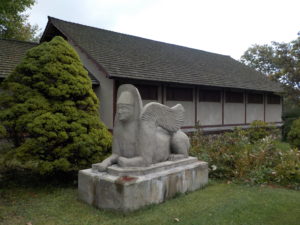
Sunday October 25 we will visit East Hill Farm, home of the Rochester Folk Art Guild, for a hike across their 350-acre hilltop farm and woodlot. The Guild is a community of craftspeople, producing fine quality handmade products in wood, pottery, fabrics, paper, toys, books and more. We will have an opportunity to visit their Gallery Shop for holiday shopping at the end of the hike – for more information about the Guild see:

https://www.folkartguild.org/about-us/ .

Please arrive by 1:45 for hiking at 2 PM.  Park on the road shoulder at 1445 Upper Hill Road, Middlesex (directions below). We will convene at the side of the East Hill Gallery, the first building on the left as you come in the driveway.

Climbers will head south through the Guild’s farm and neighboring properties, past a pond and sauna, through a spruce grove, and looping through woods and mowed fields to the Golden Valley, named for its spectacular fall color and views to the east across Italy Valley. We will return through the woods and pass an eclectic array of residential buildings, workplaces and gathering places, designed and built by community members over their 50 years of occupancy at the East Hill Farm. Total distance is about 3.5 miles. Tourists and Naturalists may shorten the hike by retracing their steps at any point. Trails are gently sloped and well cleared. As a hunting season precaution, please bring some bright colored outerwear, along with water, poles and dampproof boots.

Social: We will convene after the hike for a bring-your-own social on the grounds of the Guild’s main farmhouse.

Directionsfrom Springwater/Naples: Take Route 15 south to Wayland and Route 21 east/north to Naples. Turn right on Route 245 opposite Bob’s and Ruth’s Restaurant, at the north end of the village. Follow Route 245 north to Middlesex, about 8.75 miles.  Turn right on Route 364 and go up the hill, one mile. Turn right on Upper Hill Road and go 1.5 miles.  East Hill Farm will be on your left, at #1445.  Park on the road shoulder and walk in the driveway to the Gallery building, the white house on your left.

From Rochester and points north: Head to Routes 5 and 20 via Bloomfield or Canandaigua. At the east edge of the City of Canandaigua (first light after Wegmans/Post Office), turn south on Route NYS Route 364 (a.k.a. East Lake Road).  Follow Route 364 south 12.5 miles to Middlesex, where 364 turns to the east and you will make a left onto Route 245 and then an immediate right to continue on 364.  Go up the hill, one mile. Turn right on Upper Hill Road and go 1.5 miles.  East Hill Farm will be on your left, at #1445.  Park on the road shoulder and walk in the driveway to the Gallery building, the white house on your left.

Posted on by

The Glens West of the Bay

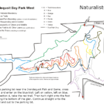
A month ago we hiked in the Abraham Lincoln Park on the east side of Irondequoit. This month we are headed across the bay to Irondequoit Bay West Park. The terrain on this side is quite similar to the east side, but the park has a different feel, partly because it is open to mountain bikes.  The extensive trail system is mostly maintained by the Genesee Regional Off-road Cyclists. Due to the season, we aren’t expecting to meet many cyclists, but please remember that we are enjoying the trails because cyclists have volunteered to maintain them.

Most of the trails we plan to follow are shared use trails, and all users should be aware of traffic. Cyclists are expected to yield to hikers who are hiking, but hikers who are enjoying the scenery should step aside for cyclists.

During our pre-hike, these trails were very easy to follow. The leaves had been swept from the trails and the trails were well used and smooth. The trails are only blazed at intersections, so be careful to check your trail each time you come to a crossing.

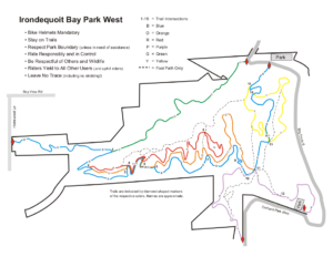
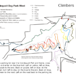
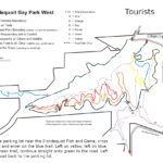
The are many ways to follow the trails. Below are suggestions for three length hikes. A PDF of all of the maps can be downloaded and printed.   Please click on each map to the right for more details.     

All hikers will meet on the north east side of the park where Glen Haven Rd enters the park.  There is a small parking area at the sharp corner at the end of the Green trail, and a second larger parking area about 400 feet east on the left near the entrance to the Irondequoit Fish and Game store and across from the start of the Blue trail.

The Climbers will walk west on the road about 100 yards to enter the park on the green trail.  This trail follows above an old path to cottages. All that is left of the cottages are the foundations to the right of the trail. The green trail ends at the blue trail near a bridge across the creek. Turn right on the blue trail as it climbs to the west side of the park. Trail maintenance has done a nice job on the bridges of this section. At the road, turn around and follow the same trail back down to the green trail.  Turn right to stay on the blue trail  The blue trail follows the southern edge of the park, parallel to the red and orange trails, so pay attention to the blazes if you want to stay on the blue trail. At intersection 11 (see the map) at the eastern side of the park, a purple trail leads down to the southern parking area. Based on interest and time, the Climbers will explore this trail, down and back. On returning to the intersection, turn right on the blue trail.  At the next intersection, turn right onto the yellow trail for a pretty trip above the bay. When you return to the blue trail, turn right to return to the cars. (An alternate route follows a foot path up the hill between the blue and yellow trails for a view of the bay from on high!).

The Tourists and Naturalists will start on the blue trail directly across from the main parking area.  At the first intersection, the yellow trail goes to the right and the blue trail heads up the hill.  This is a good time to notice the blazes the you will see at every intersection.  Stay on the Blue trail to the next intersection where you want to switch to the yellow trail to enjoy an overlook of the bay. The yellow trail will rejoin the blue trail and hikers will continue straight onto the blue.  At this intersection, there are two steep trails up to the tops of the hills.  These are not blazed and are for the use of hikers only (no bikes). Check the map if you would prefer to follow these trails.

At the next intersection (with blue, purple and orange blazes), continue straight on the blue trail.

At intersection 4, the Naturalists will leave the blue trail to stay on the red trail for a very short distance and then turn right to follow a hiking only trail back to the cars.

The Tourists will stay on the blue trail until it comes to the green trail and then follow the green trail back to the road and the cars.

With COVID and the early sunset, no social is planned following the hike.  Hikers may want to explore the road along the bay to the south side of the park.

Please enjoy the holiday season and stay safe for your family and neighbors.

Directions:

From Springwater: Follow NY 15A or NY 15 north to I-390. In Rochester, merge right onto I-590 N. At the intersection with 490, stay left to continue on 590N. Take exit 9 for Bay View Rd. Turn left onto Bay View Rd, and take the 3rd right onto Glen Haven Rd. In less than a mile, you will enter the park (the road name changes to S Glen Rd and then to Bay Front S, but don’t worry about that). There are two parking areas within 400 feet of the entrance to the park.

From Naples: Follow NY 21 north to NY 64 in South Bristol, to US 20. Turn left on US 20, then in a mile, turn right on NY 444 to Victor. Turn left on NY 96. In 2.9 miles enter I-490. Use exit 21 for NY 590N. Take exit 9 for Bay View Rd. Turn left onto Bay View Rd, and take the 3rd right onto Glen Haven Rd. There are two parking areas when you reach the park.

From Canandaigua: Follow NY 332N to the Thruway west. Take exit 45 for I-490. Take exit 21 for NY 590N. Take exit 9 for Bay View Rd. Turn left onto Bay View Rd, and take the 3rd right onto Glen Haven Rd. There are two parking areas when you reach the park.

Posted on by

Hiking Tour – Canandaigua Historic Districts

Springwater comes to Canandaigua in 2020! Katherine’s tree at the Granger Homestead

Please join us on Sunday Dec. 6 for a sidewalk hike showcasing the some of best of Canandaigua’s historic districts and landmarks. The tour begins at central civic square, site of the original land office for the Phelps and Gorham Purchase, and heads northeast from there, looping through the historic residential neighborhoods of Gorham, Gibson and Howell Streets with their outstanding examples of architectural styles from the Federal through the Colonial Revival.  Former City Planner Saralinda Hooker will provide a general orientation and tips on outstanding properties to note. This is not a building-by-building informational tour, but rather a moderate speed hike; we will keep moving and stop as a group only at a few selected locations, maintaining distance guidelines. The hike is fairly level and all paved, but bring warm clothes, water and a mask. Also an umbrella or hood if showers are predicted.

For those who would prefer a shorter hike, more reading, more detail about individual sites, and less of a crowd, bring your smartphone. A self-guided online tour of the central section of Main Street is available (compliments of the Ontario County Historian’s Office), starting at the Historical Museum at 55 North Main Street and extending a few blocks both north and south from the central square. For a preview, see:  https://www.co.ontario.ny.us/383/Main-Street-Guided-History-Walk    The historic images in this online tour are enlightening.

Meet at 1:45 under the West Avenue railroad bridge, past the lower end of Atwater Park. The Climbers will make a loop of about 4 miles, going as far as the Sonnenberg Gardens gate and the VA campus and returning on North Main Street for a total of about 4 miles. The Tourists and Naturalists can cut the loop short by returning on Howell Street and North Main for a walk of about 2.5 miles, or can make use of the online tour at your own pace.

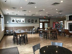
Social:  Social gathering after the hike at the Cheshire Farms Creamery, 10 Parrish Street (turn right at the Parrish Street light, two blocks south of the business district).  This restaurant specializes in ice cream, but also has a food menu including sandwiches, quiche, and other light supper fare. The Creamery’s indoor seating area  has a variety of table sizes, well-spaced – see photo below.

Directions:

From Springwater and Wayland – Take Route 15A to the north end of Hemlock Lake, then go right on 20A through Honeoye and east to Route 64, where you will turn left (north). At Toomey’s Corners, make a right on Routes 5 and 20 and head straight into Canandaigua. Do not fork right at the 5&20 bypass, but continue straight on West Avenue. Park along the left side of West Avenue just before the railroad bridge and just past the Dollar General Plaza.

From Rochester:  Take Route 490 to join the NYS Thruway at the Victor ramp (Exit 45). Go east one exit and get off at Farmington/Canandaigua (Exit 44). Take Route 332 south 5 miles to the City of Canandaigua, where it becomes Main Street. When you come to the center of town (Court House, City Hall, etc – can’t miss it), take a right at the traffic light on West Avenue. Go under the railroad bridge and park along the side of the road on your right, just past the bridge.

Cheshire Farms Creamery