Posted on by

Ganondagan Hike

Springwater Trails started as the Springwater Parks and Trails Committee around 2010 with initial funding from the Fiddler’s Fair. This committee was modeled after the Crescent Trail Association, a non-profit, incorporated organization active since 1980 with the full support of the town of Perinton.  They have created over 23 miles of foot trails in the town. In the early 90’s, residents of the Town of Victor created a similar  organization to develop and maintain trails in Victor.  They adopted Bylaws and created a not-for-profit corporation in 1992 and continue to develop and expand their trail system. According to their strategic plan published in 2016, 55 miles of trails have been developed in Victor with 28 miles maintained by Victor Hiking Trails (VHT), 15 miles by Genesee Region of Cyclists (GROC) and the rest by the town of Victor.
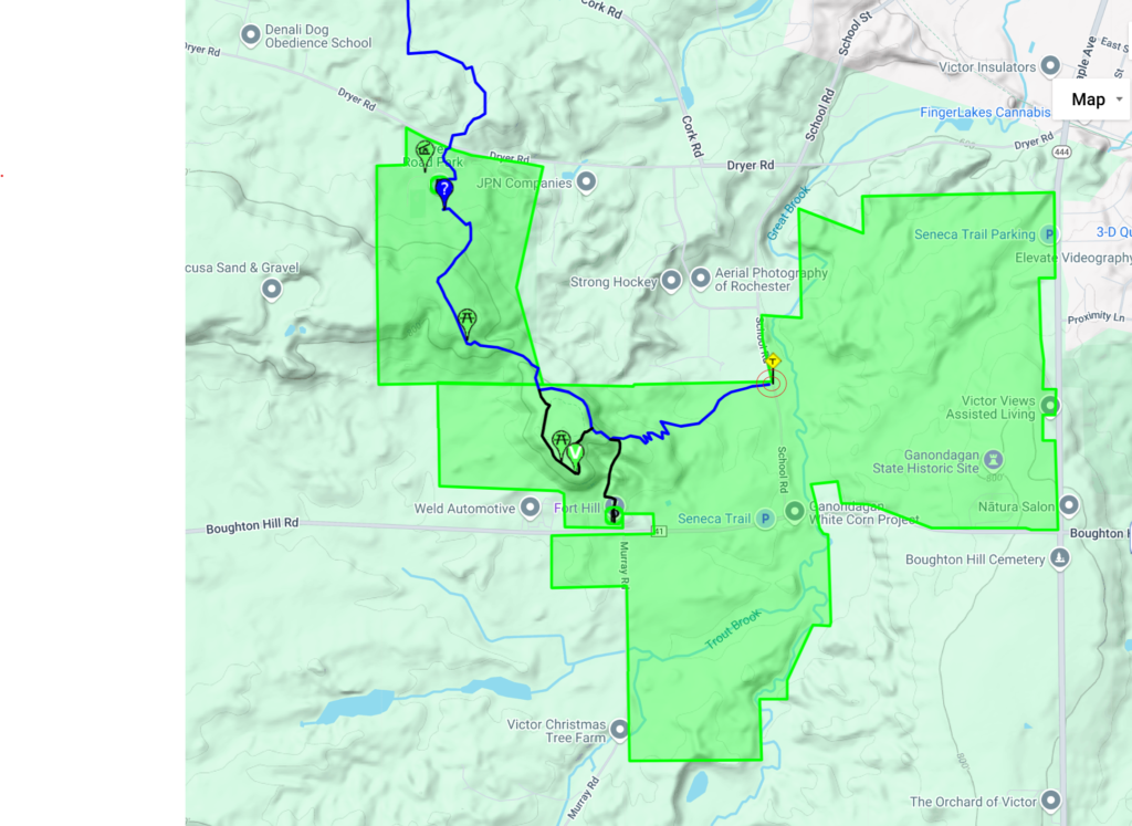
This Sunday, we will explore the Dryer trail located in Ganondagan State Historic Site and in Dryer Rd Park. Dryer Road Park is the home of 15 miles of bike trails (Click that link for an amazing map).

We will lead two hikes. Both hikes will be out and back, starting from the parking area on School St. This lot has only 7 parking spots, so carpooling would be good.  We can also double park within the group. And there is a large parking area on Boughton Hill Rd where overflow can park and then carpool to School St.

Linda will lead the Naturalists and Tourists along the Blue Dryer Trail up Fort Hill to the Granary Trail that loops around the top of the hill where a Seneca granary store a significant amount of corn prior to July, 1687, when the Denonville campaign from Montreal destroyed Ganondagan and burned the granary. Hikers can read entries from the Denonville journals and enjoy views to the south of the hills around Canandaigua Lake. The trail up Fort Hill has several switchbacks making it a much easier route than the other trails to the granary.

The Climbers will stay on the Dryer Trail to Dryer Road Park. On the return hike, we will stop at the Granary as time permits.

Following the hike, join us for a social at a local restaurant.

Directions 

Can be easily found using GPS

From Springwater and South – Take Route 15A north Just past the green dollar store in Hemlock make a right onto 20A.  Make a left onto County Rd. 37 just before the Valley Inn on the corner.  Take County Rd. 37.  Continuing straight it will become Rt. 65, then W. Bloomfield Rd. (CR-35).  You will turn right onto Boughton Hill Rd. (CR-53 which becomes 41) Make a left onto School St and the parking lot will be on the left.

From Rochester, take I-490 to the Victor exit, then Route 96 to Victor. At the second traffic light in Victor, use the right turn lane onto School St. Continue on School St (it switches to School Rd outside the village) for 1.5 miles. The parking are is on the right.

Alternate parking is available at the Visitor Center. Go south from the School Rd lot to Boughton Hill Rd. Turn left, and the parking lot in on the left.

Posted on by

Middlesex Valley Rail Trail

WEATHER UPDATE:   Good cross country ski conditions, bundle up for cold temperatures!
The trail has about 3″ of snow in both directions, so bring your cross country skis if you’d like to try skiing the trail. On Saturday the snow was fluffy and skiable on top, though wet enough to stick to the underside of the skis in certain sections. With the overnight cold, the ground should be more frozen and snow conditions should be even better on Sunday. We suggest bringing a variety of equipment types to test out what works best for you. Conditions are also fine for walking in regular hiking boots.   
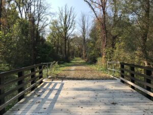
This Sunday, for a leisurely break from the holiday scene, we will hike sections of the Middlesex Valley Rail Trail, passing through the lowlands of the Hi Tor Wildlife Management Area between Route 245 and Route 21, just north of Naples. The Middlesex Valley Railroad began service in 1892 between Naples and Stanley, with connections to Geneva, Canandaigua and Wayne County. In 1895 it became part of the Lehigh Valley Railroad system, and continued in service until 1970.  Now the 7-mile rail trail is  a raised path with wetlands on either side – some shrubby and some forested. The section between Parrish Road and Naples has been closed to hikers in recent years, but DEC has now completed the necessary Naples Creek bridge repairs to reopen this section, so this will offer a new experience for most SWT hikers.
We will meet at 1:45 PM at the parking area on the north side of Parrish Road, which runs across the valley from Route 21 (near Monica’s Pies) to Route 245 (near the base of Conklin Gully).  From there hikers will choose between the 2.25 round trip south toward Naples or the 4.25 round trip north toward the West River Boat Launch and Sunnyside, or go as far as you like at your own speed and turn around when ready. In both directions the trail is level, mowed and mostly well drained – an easy hike, no poles required unless you always use them. Expect some muddy conditions, so waterproof footwear is a must. Wear layers, and plan to walk as fast as you need to keep warm.
Social: Following the hike, please join us for an optional social at Brew and Brats at Arbor Hill, 6461 State Route 64, about 5 miles to the north of the hike start along Route 21 (bear left when Route 64 splits off from 21).  Menu includes craft beer and other beverages, brats and other pub food:  see https://brewandbrats.com/wp-content/uploads/2024/10/BNB-Winter-2425-MENU.pdf      Note that Brew and Brats closes at 5 on Sundays. 
Directions to the Hike Meeting Point:
From Springwater/Dansville/Wayland: Take Rt 21N into Naples. Turn left onto Main St for 1.5 miles. Turn right on Rt#245 (across from Bob and Ruth’s). Continue 1.5 miles, make a left on Parrish Rd. Parking area is on the right, in about .2 miles.

From Honeoye: Take Rt#36 south into Naples, left on Main St for approximately 1.25 miles. Right on Rt#245 (Across from Bob and Ruth’s). Continue 1.5 miles then left on Parrish Rd. Parking area is on the right, in about .2 miles.From Canandaigua: Take Rt#21S to Woodville. Keep straight toward Naples. Turn left on Parrish Road about 1.5 miles past Woodville, just after you pass Monica’s Pies. The parking area will be on your left, in about .5 miles.

Posted on by

Mount Hope Cemetery Hike

Provided by Tripadvisor

Mount Hope Cemetery in Rochester, NY is one of the most remarkable Victorian cemeteries in America.  Since the cemetery’s dedication in 1838, a third of a million people have taken permanent residence in this exquisitely beautiful 196-acre site.

Hikers will walk the grounds on flat paved roads exploring thousands of monuments made from granite, marble, limestone, sandstone and bronze etc. fashioned into Greek temples, soaring Egyptian obelisks, ornately carved steles and columns, winged angels, bas relief portraits, stone figures in flowing robes along with flora and fauna of exquisite detail.

Along the way, hikers will also stop to visit some of the well-known graves including Susan B Anthony, Frederick Douglass, Nathaniel Rochester and William Warfield to name a few.  For additional information, check out Friends of Mt. Hope Cemetary www.fomh.org

Hikers will meet at 1:45pm at the North Gate entrance parking area in front of the 1862 chapel.

Social

Following our hike, join us for a social at Elmwood Inn– 1256 Mt. Hope Avenue, Rochester, NY 14620 (practically a stone’s throw from the cemetery entrance.)

Directions

Mt Hope Cemetery is about 45 minutes north of Springwater, so carpooling should be considered.

From Springwater: Head north on NY 15A for 19 miles to Lima. Turn left on US-20 for 4.2 miles. Turn right onto I-390 N. At the split with 590, stay left on I-390 and then stay right to exit 16B for NY 15A/E Henrietta Rd. Continue straight past South Ave and turn right onto Mt Hope Ave. Go up and over the hill for 1.8 miles to the second entrance to the cemetery (north entrance).  There is parking inside the entrance.

From Naples: Take CR-36 (West Lake Rd) to Honeoye. Turn left on US-20A. In 5 miles turn right onto NY-15A and follow the Springwater directions.


Posted on by

Sandy Bottom Hike/Honeoye Area Ride

PLEASE NOTE – CHANGE OF HIKE MEETING PLACE,  BIKE RIDE CANCELLED

Come join us for a hike in Sandy Bottom Park, starting from the East Lake Road Trailhead. The bridge and boardwalk linking the two sides of Sandy Bottom Park are out of commission for a few weeks, so we will meet at 1:45 at the 4932 East Lake Road parking area and limit our hike to the 1.5 mile loop around the field and down to the stream to observe the improvements. Those seeking a longer hike are invited to go around again.  The planned bike ride is cancelled due to rain.

Hikers will explore the nature trails and wetlands of Sandy Bottom Park.  Our hike (about 1.5 or 3 miles) will be a combination of field and woods on a relatively flat terrain. Recommended attire – rain gear, umbrella, and sturdy waterproof shoes with good treads.

Social:  Please join us to dry out after the workout at the Bird House Brewery, 8716 Main St, Honeoye, NY 14471. For menu see: https://commerce.arryved.com/location/BeNKYUPu/modality/pickup

Directions:
From Springwater: Head north to Route 20A in Hemlock. Turn east on 20A. Go through the Village of Honeoye to the East Lake Road intersection, just past the School, make a right and go about .3 miles to the Sandy Bottom Trailhead on your right.

From Naples:  Go north on County Road 36, and right on Route 20A at the Honeoye traffic light. Go through the Village of Honeoye to the East Lake Road intersection, just past the School, make a right and go about .3 miles to the Sandy Bottom Trailhead on your right.

From the east (Bristol, Canandaigua, etc): Take Rte 64 south to Rte 20A, make right onto 20A, left onto East Lake Road as you come down the hill into Honeoye. Go about .3 miles to the Sandy Bottom Trailhead on your right.

From the west (Hemlock, Livonia, etc): Take Rte 15A to Route 20A, go through the Village of Honeoye to the East Lake Road intersection, just past the School, make a right and go about .3 miles to the Sandy Bottom Trailhead on your right.