Notice: Sunday, Oct 8, 2023: The weather forecast seems to be consistently predicting rain and wind peaking at 3:00. So, check for updates before you head out today. We will hike if there is no lightning and there are hikers dressed for rain, but hikes may get shortened based on the weather. Also note the change to the social below. If you don’t come today, we will be at the the Folk Art Guild in Middlesex next week if the weather improves. Also note the change to the social below.
Rob’s Trail offers a peak opportunity for Finger Lakes hiking – a delightful woods walk from one Finger Lake to another. The full 8-mile walk is longer than our usual SWT event, so we’re planning separate start times and places for those wishing to do the full lake-to-lake distance, with shorter and easier hikes available to the Tourist and Naturalist groups.
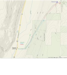
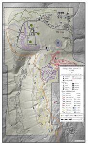
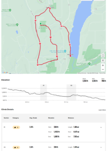
For Climbers – lake to lake hike: meet at 12:45 for 1PM start at the Hemlock Lake north boat launch. 42.742059, -77.608443 We will hike for about 2.5 miles along the Hemlock lake shore, then climb to the Route 15A crossing and over the ridge on the loop trail, with a snack and rest break at the mid-point. We will descend on the Canadice side of Rob’s Trail and return to the Purcell Hill Road trailhead for carpooling back to the start. Estimated time is 3.25 hours. If you are seeking a possible bail-out in the middle, contact Saralinda through Comments section and we can arrange for an escape plan at Route 15A. Poles and rain gear are recommended, as showers are predicted and the ground will be slippery from earlier rains.
For Tourists and Naturalists – Canadice Lake Trail and Rob’s Trail to the Loop: meet at 1:45 at Purcell Hill Road trailhead for 2PM start. 42.743197, -77.574363 Tourists will hike 1.75 miles to the Rob’s Trail intersection and up to the ridge, around the loop trail, and back to the start the same way. Total distance about 4 miles with some moderately steep sections. Poles and rain gear are recommended, as showers are predicted and the ground may be slippery from earlier rains. Naturalists will follow along with the Tourists until the Rob’s Trail intersection, but remain along the Canadice Lake Trail as far as you want and return. All relatively level terrain, good wide trail surface.
Social – Join us for refreshments afterwards at the Valley Inn, 8790 Main Street, Honeoye (corner of Route 20A and County Road 37.
Directions – to Hemlock Lake North Boat Launch (for Climbers only, at 12:45 PM) – From Springwater: proceed north on Route 15A 19 miles, then make a left on Rix Hill Road and an immediate left on Old East Lake Road, a.k.a Boat Launch Road. From Honeoye and points east: Take Route 20A west from the Bristol Valley and Honeoye. When 20A meets Route 15A, make a left and go about .6 miles to Rix Hill Road. Make a right and then an immediate left on the boat launch road. From Rochester and points west: Take Route 15 south from Henrietta or Route 15A south from Honeoye Falls, or Route 390 south to the Lakeville-Livonia exit, then go south on Route 15 and then east on Route 20A through Hemlock. When Route 20A turns east toward Honeoye, go straight another .6 miles and make a right on Rix Hill Road. Then make an immediate left onto the boat launch road and go to the end, 1 mile.
Directions – to Canadice Lake Trail (for Tourists and Naturalists, at 1:45PM) From north: Route 20 between Honeoye and Hemlock, go south on Canadice Lake Road and west on Purcell Hill Road. The Canadice Lake Trailhead will be on your left. From south: From Springwater, go north on Route 15A to Johnson Road, make a right and then a left on Canadice Lake Road. Pass the lake and make a left on Purcell Hill Road. The trailhead parking area will be on your left.
Directions to Valley Inn for Social – From Purcell Hill Road, return to Canadice Lake Road and go north to Route 20A and east toward Honeoye. The Valley Inn is on your left at the intersection with County Road 37.


