Posted on by

Hi Tor Hike

This Sunday’s hike at High Tor Wildlife Management Area in Naples will take us back to many of our previous hikes including:

  • a hike by Springwater Parks and Trails at least one and a half decades ago
  • a winter hike just before Covid hit
  • and a follow-up to our maintenance hike on the Blue trail three weeks ago.

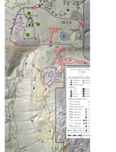
We will all meet at the DEC parking area on Basset Rd near the west end of the road (See the map to the right).  Please arrive in time to start the hike at 2:00 PM. We will have two hikes based on distance.  Hike leaders may adjust the hikes to accommodate our hikers and the weather. Please note: in the following hike descriptions, the term road refers to the maintenance road, which  is more accurately called a wide trail.
All hikers will start on the same trail out of the parking area. The Naturalists will take the left route and follow the maintenance road up to the BHB orange trail. Turning left onto the BHB (orange blazes) they will quickly come to the pond and will explore the shore of that. Returning on the BHB to the maintenance road, the Naturalists will follow their own footsteps back to the cars.

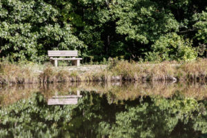
The Finger Lakes Trail from Naples to Parrish Gully. The Howard Beye memorial bench.

The Tourists will join the Naturalists up to the BHB orange intersection. The Tourists will continue straight on the maintenance road to the lean-to and overlook of Canandaigua Lake. Returning on the road, they will retrace their steps to the point where the BHB turns right. The tourists will continue straight (not on the BHB) south to the cars. They will likely meet up with the Naturalist on the final leg and will then return together to the cars.

The Climbers will also take the same route as the Naturalists. When they reach the BHB orange trail, the will turn left and continue around the pond. The Blue trail will break off to the right and the Climbers will follow that down to the Finger Lakes Community College property on East Hill Rd. Climbers are welcome to bring small clippers to do minor maintenance on the trail as we go.  We will station a couple of cars at the final parking lot to ride back to the start point.

Following the hike, please join us for a social at Kelley’s home in Atlanta (NY).  See directions below.

Directions:

From Naples: Take NY 53 south from Naples for 1.1 miles. Turn left onto Italy Valley Rd (CR 21) for 2.1 miles. Turn left onto Basset Rd, when the main road takes a sharp right turn. Parking is on the left in 0.2 miles.

Additional directions are available here.

Directions To Kelly’s in Atlanta: Return to Naples by going right out of the parking area, then right onto Italy Valley Rd, then right onto NY-53 N. In 1.3 miles, turn left onto NY-21 S. In 4.5 miles, in N. Cohocton, turn right to stay on NY – 21. Take the next left onto University Ave. In 0.4 miles, Kelly’s home is the second house after the farmer’s field on the right.

Posted on by

Ontario County Park Hike

Please join us for a hike on October 6th at Ontario County Park (6475 Gannett Hill Park Dr, Naples). We will be following trails on the east side going up Gannett Hill.  Meet at the last parking area, 1.1 miles from the Park Office where campers check in. This is past our usual parking area near the Jump-Off, and part way down the far side of the loop, near the pond. Please arrive at 1:45PM to sign in, get trail directions and be in the group photo. We start the hike at 2:00PM.
Ontario County Park- Even though the park is named after newspaper mogul Frank Gannett, the Gannett family never owned any of what is now the park. The original 300 acres was owned by the Watkins family. It all started in 1916 when a Boy Scout troop from Canandaigua, received permission to hike the hill and camp out. Once the press got wind of the story, the outing became an annual event and the tourists starting coming. In1963, the Watkins family sold the property to Ontario County and the park was named with the Gannett name due to Frank being a prominent figure in the Rochester area. Starting in 1967, there have been a number of improvements made: a four-million gallon reservoir pond, “jump off” retaining wall, 410 Acres of woods and open land, pavilions, restrooms, dozens of hiking and biking trails.
What to expect on today’s hike – Fall colors are starting to appear. If it didn’t rain yesterday, all trails we’ve plotted out are pretty clear of weeds, have good footing (not super steep) and are mostly wooded. There is one meadow area that has several types of wild flowers (maybe Aster and Snakeroot?). There’s also a wild apple grove. The woods are loaded with Oak, Birch, Hickory and Beech. Keep an eye out for tiny toads crossing.  
Naturalists and Tourists will start off following the Yellow Trail, then Bristol Hills Trail, White/Yellow Trail, slowly ascending up Gannett Hill to the far south/east end of the park. Then make the round trip back on the Yellow trail, and back to our cars. Total time should be about 1.5hrs  covering 1.75 miles.
Climbers will start on the same trail as the Naturalists but take a sharp turn east going down and up many trails the Rochester Biking Group maintains.

There are a few moderately steep inclines/declines. Many of these trails are poorly marked so keep up with the leader who’s using GPS. Climbers will be ascending up Gannett Hill to the far south/east end of the park, then on the the round trip back, dip lower down the hillside before its back up to our cars. Total time should be about 1.75hrs  covering 2.5 miles.

Social: Following our hike, we will drive back around the park loop to the Wilson Lodge parking area and gather for the social at an open pavilion near the Wilson Lodge rest rooms. Please bring a dish to pass or contribute $5. Bring your drink and maybe a chair.

Directions:
— From Rochester: The easiest route to the park is to take NY 64 (Pittsford Mendon Rd). When NY64 meets 5&20, turn left. It’s still NY64. Stay on 64 as it turns right onto 20A. Continue on Rt 64 thru South Bristol and turn right (west) on Gannett Hill Rd.  There is a sign indicating Ontario County Park.  At the top of the hill turn right onto  South Gannett Hill Road. The park entrance is straight ahead.  From the camping check in booth, follow the park road around the loop for about 3/4 mile to our meeting place which is the last parking area before you exit the park, close to the pond.
— From Springwater, Wayland and Naples: From Springwater, head south on NY-15. At the light in Wayland, turn left and follow NY-21 through Naples. Just past the village, bear left onto CR-12 (Bristol Springs Rd). In 1.9 miles, bear left onto Rhine St. Continue straight (In .6 mi, the name changes to Powell Rd and then in .3 mi to Gannett Hill Rd, and then in 3.2 miles it enters the park). From the camping check in booth, follow the park road around the loop for about 3/4 mile to our meeting place which is the last parking area before you exit the park, close to the pond.
 
—From Hemlock and Honeoye: From Hemlock, head south on NY-15A. Just outside of the hamlet, turn left on US-20A. Continue through Honeoye and turn right onto East Lake Road. In 0.6 mi, turn left onto CR 33 (Egypt Valley Rd.). In 6.9 miles, continue straight onto CR 34. In 1.6 miles, turn right onto NY-64. In another 1.9 miles, turn right onto Gannett Hill Rd. In 1.3 miles, turn right into the park. From the camping check in booth, follow the park road around the loop for about 3/4 mile to our meeting place which is the last parking area before you exit the park, close to the pond.
—From Canandaigua: Take US 20 west out of the city. Turn left onto Parrish St Ex. In 0.9 miles, turn left onto NY-21. Continue for 11.9 miles to the intersection with NY-64. Turn right onto NY-64 N. In 0.4 miles turn left onto Gannett Hill Rd. In 1.3 miles, turn right into the park. From the camping check in booth, follow the park road around the loop for about 3/4 mile to our meeting place which is the last parking area before you exit the park, close to the pond.
Posted on by

June Bug Trail or Hammondsport Walking Tour

We will visit the picturesque and historic Village of Hammondsport on Sunday September 29th, with two options. Those in favor of a vigorous woods walk will hike a combination of hillside trails southeast of the village including the June Bug Trail, while those interested in a more leisurely but scenic walk around the village will stay at lake level and enjoy a tour of the historic village and waterfront.  We will meet at 1:45 and start together in separate directions at 2 PM from the Glenn Curtiss Museum, at 8415 Route 54, just southeast of the village. The two groups will reconvene at about 4PM for a dish-to-pass social at Champlin Beach, a mile to the north on Route 54, just north of the fire station. Come early if you’d like to explore the Museum, which features exhibits on Hammondsport and Keuka Lake history as well as on the career and exploits of Hammondsport’s own Glen Curtiss, early 20th century pioneer in the fields of bicycling, motorcycling and aviation. See   https://glennhcurtissmuseum.org/   for more on the museum, which is open until 5. Watch for the airplane in the front yard.

Climbers and Tourists will cross Route 54 and head up the June Bug Trail to the hilltop ridge along the east side of Pleasant Valley – a significant climb, but well worth it. At the hilltop, we will join the a beautiful section of the Finger Lakes Trail going south along the ridge, returning the same way for a hike of about 3.5 miles. Poles will be helpful on the climb and descent.

Naturalists and History Buffs will drive from the meeting place to public parking next to the Post Office at 76 Pulteney Street in Hammondsport and begin the walking tour at the Pulteney Square Gazebo. The tour, led by local historian Terry Bretherton, will highlight the history of the village, its public square, and the very intact Victorian cottage neighborhoods over about an hour and a half. The walking tour group will then return to Champlin Beach to enjoy the social, along with swimming or wading opportunities.

Social – Please bring your favorite goodies for our dish-to-pass social at Champlin Beach, just north of the Route 54A intersection and the fire station on Route 94. Bring your own beverage and chairs/folding table in case the pavillons are reserved. A $5 contribution to our social fund is fine in lieu of the edibles.

Directions –  From Springwater area, head south to Wayland and pick up 390 South to Bath. Take Exit 38E from 390 to Bath, and follow Route 54 north 8 .5 miles to the Glenn Curtiss Museum at #8415, on your left.

From Canandaigua and points north – take the most direct route to Penn Yan, then head south on Route 54 toward Hammondsport. Pass the intersection with Route 54A, and continue another .75 miles to the Glenn Curtiss Museum at #8415, on the right.

From Honeoye/Naples area – go the Naples and head south on Route 53 through Prattsburgh. Continue on Route 53 for 18 miles and make a left on Gardner Road, then right on County Road 13/Mitchellsville Road. At the end of Mitchellsville Road in Urbana, turn left onto Route 54. Go 1.8 miles to the Museum, on your left.

Posted on by

Maintenance Hike at Hi Tor

Hi everyone, This Sunday is our first maintenance hike of the year. As many of you know, as a group, we have been responsible for maintaining a section of the Bristol Hills Branch of the Finger Lakes Trail. Unfortunately, the section of the trail from Seman Rd to Mt Pleasant St in Naples has been closed and converted to a road walk, so now we are going to maintain the blue trail.  On our first time, we are going to do some minimal maintenance while we explore the northern section of the blue trail.  So, please bring a pair of clippers to trim back small branches and weed that are encroaching on the trail, and a walking stick that you can use to flick branches off the trail. Cloves may also be useful when the weed has thorns. And of course, bring water. Please arrive at 1:45 to allow time to plan a car pool. We expect the Tourists and Climbers will return to the cars by 4:30 after 3.5 miles of hiking.

We will not be cutting trees that cross the trail, although we may discuss future plans.

We also will not be pulling out roses and other invasives. And we will not be mowing the paths.  These items will wait until spring.

There are three options for this Sunday hike.  We will select based on attendance. All hikers will meet at the Ontario St parking lot in the Village of Naples.

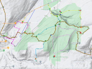
The Climbers and Tourists will car pool to the Parish Hill parking lot, which is also known as the Blue Trail parking lot, because the Blue Trail starts there. From there, we will follow the Blue Trail down to where it joins the yellow trail (click on the map to see a larger copy where you can follow the trails [or CTRL-click for a new tab]). We will follow the yellow trail (also blazed with blue) over a ridge and down to the Tom Noteware bridge across the top of Conklin Gully. There is a steep climb after the bridge, which will require care from all hikers. Unfortunately, this route is not recommended for hikers who prefer level ground.  There is an backup route if needed.  From the top of the climb, we will find enjoy views of Conklin Gully from the top. The Tourists will turn around at the lean-to/overlook and return to the cars at Parrish Hill Rd, again being careful with the steep areas. The Climbers will continue on the blue trail which follows a fire lane to join the orange trail.  We will turn right and follow the orange trail down to the cars on Ontario St.

The Naturalists will start out on the orange trail across the Naples Creek.  But at the register, they will turn left onto the Burgandy Trail along the creek. About half a mile down the trail, they will turn left onto a smaller trail and follow it back to the orange trail and turn left towards the cars. But before the bridge the will turn left and follow a trail south along the creek. This trail exits onto E Hill road. At that point, hikers can choose to turn around an walk back to the cars on the trail by the creek, or continue on the road up to  S Main Street and walk on the sidewalk back to Ontario St and the the cars.

Following the hike, we will gather at a Bob and Ruth’s on the north end of Main St.

Directions:

From Springwater and Wayland, come south on Rt. 15 to the traffic light at Rt 21. Turn left on 21 and keep going all the way to Naples. Go through the downtown business area and turn right on Ontario Street, opposite the school. Go to the bottom of the hill and the parking lot is on the left.

From Dansville, follow Rt. 63 to Wayland where the road turns into Rt 21; continue on 21 all the way to Naples. Go through the downtown business area and turn right on Ontario Street, opposite the school. Go to the bottom of the hill and the parking lot is on the left.

From Naples, go to the school on Main Street (Rt. 21). Turn down Ontario Street opposite the school, go to the bottom of the hill and the parking lot is on the left.

From Canandaigua, head south on Rt 21 through Chesire and Woodville to Naples. Turn left on Ontario Street, opposite the school. Go to the bottom of the hill and the parking lot is on the left.

From Honeoye, head south on CR 36 (West Lake Rd) from 20A for 15 miles to Naples.  Turn left onto Main St (Rt. 21). Turn down Ontario Street opposite the school, go to the bottom of the hill and the parking lot is on the left.

From Penn Yan, head west on North St and continue onto Rt 364W for 12 miles. In Middlesex, join NY 245 and continue for 9 miles.  Turn left on NY 21 South (N Main St) into Naples. Turn left on Ontario Street, opposite the school. Go to the bottom of the hill and the parking lot is on the left.