Join us to celebrate NY Maple Syrup with a Pancake lunch at Stoney Ridge Farms in Farmington, NY, followed by a hike through Victor parks to burn off any excess calories.
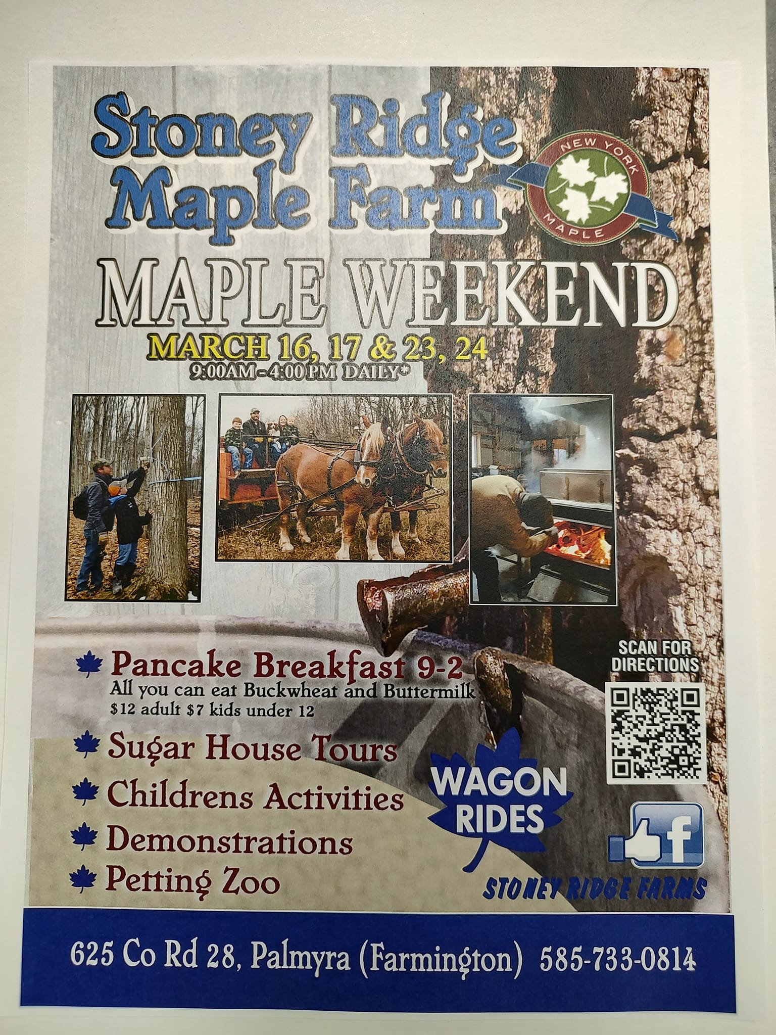 Pancake lovers will meet inside the Pancake tent at 12:00. Pancakes are $12 and are all you can eat. Included is syrup and butter for the pancakes, plus bacon or sausage and juice and coffee. While you are there, take a tour of the Sugar House to learn more about the process of making syrup and meet the owners Melinda and Chris Rodas. Pancakes are available until 2:00.
Plan to finish your tour of the farm by 1:30 for a 15-minute drive to the MaryFrances Bluebird Haven.
All hikers will meet at the trail parking lot for MaryFrances for a 2:00 hike start. See directions below. There is overflow parking south of MaryFrances off of Springdale Ct. Note, please dress accordingly for the conditions, as the trails will likely be wet and muddy at times.
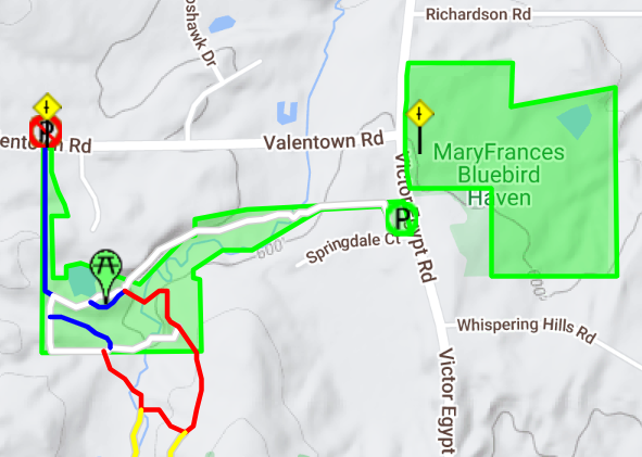 The Climbers will head south about 500ft along Victor Egypt Rd to the entrance to Monkey Run trails. These trails follow the White Brook creek and go up and down the small hills around the creek. Climbers will start on the White trail that passes behind several homes on Springdale Ct. We will turn left onto the Red Trail and follow it to a cleared route for a pipeline. Crossing the pipeline takes us to the yellow trail. From there we will loop back to the red trail (left turn on Red) and the to a left turn on the white trail. We will continue past a Blue intersection to the right and a Blue intersection to the left (which goes out to Valentown Rd). At the next blue trail, we will go right for a short side trail up to a picnic table, and then back to the white trail. From there, stay on the white trail heading east back to the entrance. From there, walk back up the Victor Egypt Rd (each hike should watch for traffic when crossing) to a trail heading south from the MaryFrances parking area. Stay on this perimeter trail around the park. The trail is close to the park boundary, so you will see posted signs. As usual, stay on the trail and quietly say thank-you to landowners when the trail wonders onto the adjacent land.
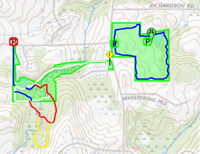 The Naturalists will follow the Perimeter Trail* (Blue) around the MaryFrances Bluebird Haven. If time permits, they will walk from the parking area down to the lodge and pond.
*Note the trail will likely be wet and muddy for about half of the outer perimeter of the trail. Please dress accordingly.
Our social this week will be at Stoney Ridge farm BEFORE our hike.
Directions to the Hike:
From Stoney Ridge: Head west on Rushmore Rd for 1.7 miles. At the T, turn right on Sheldon Rd (for 0.7mi) and then the first left on Holtz Rd. In 0.6mi the name changes to Martz Rd for 0.6mi. At the next T, turn left on Hook Rd (for 0.4mi) and take the first right onto Yahn Rd. At the next intersection (0.9mi) turn right onto Weigert Rd, then left (in 0.6mi) on Brownsville Rd. The road turns right and becomes Cline Rd, but you will quickly turn left onto Gillis Rd. At the stop sign, turn right on Victor Egypt Rd. In 1.1 miles, just before Valentown Rd on the left, turn right into the MaryFrances entrance. The parking lot is immediately on the right.
From Springwater and Honeoye: travel NY Rt 15A northbound (to just s of hamlet of Hemlock) ; turn right/eastbound onto NY Rt 20A (eventually passing through the hamlet of Honeoye, and continuing on NY Rt 20A northeasterly to just south of the hamlet of Bristol) ; turn left/northbound onto Co Rd 2 aka Oakmount Rd, pass through the hamlet of Bristol and continue straight on what will eventually become Oakmount Ave, crossing NY Rt 20 <USE FOREMOST CAUTION at this crossing!> to jct with Main St in Village of Bloomfield ; turn right/eastbound on Main St ; turn left/northbound onto NY Rt 444 (aka Elm St which becomes Victor Holcomb Rd which becomes Maple Ave) to jct with NY RT 96 aka East Main St in the Village of Victor ; turn right/eastbound onto NY Rt 96 aka East Main St ; turn left/northbound onto Church St ; Church St becomes Victor-Egypt Rd aka Co Rd 9 ; travel to 235 Victor-Egypt Rd where Mary Frances Bluebird Haven driveway is located ; turn right onto the entrance driveway. The parking lot is immediately on the right.
From Canandagua: Head north on NY 332. Turn left on NY 96. In 2.3 miles at the traffic circle, turn right onto Lynaugh Rd. In 1 mi, turn right onto Victor Egypt Rd. In 2.3mi, turn right onto the MaryFrances driveway. The parking lot is immediately on the right.
From Naples: Head north on NY 21. At the junction with NY 64, continue straight onto NY-64. Continue for 13 miles. At the light, turn left onto US-20. In 1.2 miles, turn right on NY-444 into Victor. In 6.8 miles, turn right onto NY Rt 96 and then turn leftonto Church St ; travel to 235 Victor-Egypt Rd where Mary Frances Bluebird Haven driveway is located ; turn right onto the entrance driveway. The parking lot is immediately on the right.
To Stoney Ridge before the hike: (43.0088, -77.2764):
Stoney Ridge Farms is located at 625 County Road 28 in the Town of Farmington (PO Palmyra) New York.
From Canandaigua: Head north on Route 332. Turn right on County Road 28. Go 7.6 miles. Stoney Ridge Farms is 1 mile past the thruway overpass on the right. Turn right on Rushmore Road and park.
From Springwater and Honeoye: Follow US 20A E for 7 miles. Turn left on NY 64 for 3.7miles. At the light, turn right on US 20. After 2.9 miles, bear left onto Buffalo St Extension. In 2.6 miles, turn left on Rt 332 (N Main St). In a half mile, turn right on North St (CR 28) for 7.6 miles. Turn right on Rushmore Rd and immediately into the Sugar House parking area.
From the East
From Thruway Exit in Manchester, take Route 21S in Manchester to Rt. 96N. Go 3 miles, turn right on County Road 28, go 2 miles to Stoney Ridge Farms, turn right onto Rushmore Road and park.
From the West
From 490E, take last exit to Rt. 96S in Victor. Follow Rt. 96S, 8 miles to County Road 28, turn left. Go 2 miles to Stoney Ridge Farms on right. Turn right on Rushmore Road and park.
From the North
From Fairport and Palmyra take Rt. 31. Turn on to County Road 28 (Macedon Rd.) Follow to Rushmore Road, turn left and park.