Canadice Outlet – Sunday May 12, 2013 at 2:00PM

This week’s hike will explore the Canadice Outlet Creek and remains of a 19th century community called Dixon Hollow. The area lies within the Hemlock-Canadice State Forest. We will follow an old abandoned road to the creek which passes through a deep gully environment. We will begin our hike at Pam Masterson’s home, 5107 Old Bald Hill Road (N) not (S), in Hemlock. Old Bald Hill (N) is just a little south of Hemlock off Rt.15A, across from the entrance to Hemlock Park. Since we are accessing private property, we will begin our hike promptly at 2:00. Please plan on arriving by 1:45 and respect other hikers by being on time. The black flies have unfortunately arrived, so be prepared with bug spray.

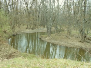
The Canadice Outlet is a 4 mile creek connecting waters from Canadice Lake to Hemlock Lake and Hemlock Creek. It begins at the north end of Canadice Lake at the spillway which controls the overflow of Canadice Lake. It ends at the dam on Rt.15A where it is either channeled underground to a block structure at the North end of Hemlock Lake, passed through or over the dam when the waters are high during spring runoff or heavy rainstorms, or when the City of Rochester does not need the waters from Canadice Lake. The waters from the outlet flow into the Hemlock Creek, which eventually joins with the Honeoye Creek, Genesee River and then Lake Ontario. The lands around the Canadice Outlet Creek are part of the Hemlock/Canadice State Forest and are mostly landlocked by private landowners. For more historical information contact hemlockandcanadicelakes.com.

Naturalists will follow an abandoned road that historically connected Rt 15A with Canadice Lake Road. The route will begin with a slight decline into a gully area where the fast moving waters turned in the oxbow areas to power old mills. Hikers will follow the creek bank to the stone remains of an old steel bridge and old mills. From there they can choose to cross the creek into Dixon Hollow, rest by the creek, or wander in the state forest identifying spring woodland wildflowers such as bloodroot, blue cohosh, trilliums, wild geraniums, forget-me-nots, flowering periwinkle, and more. Save your energy for a slight uphill climb back.

Tourists and Climbers will be broken down into two groups depending on numbers. Both groups will follow a similar hike as the naturalists, extending their hike across the creek into Dixon Hollow at different locations. They will explore the old remains of houses and mills, following the creek south to reach the Mather’s Mill location. From the mill they can cross the creek and bush wack back to Old Bald Hill Road. Climbers can extend their hike by following markers to the logging road by the old cemetery on Canadice Hollow Road for pick up or choose other alternative routes.

After hike social will be at Pam Masterson’s house at 4:00. Spring wild edibles will be sampled and maple pulled pork will be provided. Please bring a healthy dish to pass and your drink of preference.

Directions: Rt 15A to Hemlock. North Old Bald Hill goes east uphill off Rt 15A just across from the entrance to Hemlock Park and the north end of the lake. The Masterson house is located on the east side of the road, 5107 next to the blue farmhouse on the big curve. Take driveway back into the woods. Climbers may want to coordinate a car for pick up at the cemetery on Canadice Hollow Road.

Old Bald Hill North – Directions

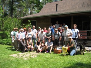
The Springwater Trails hiking group - June 2011

The Springwater Trails hiking group
June 2011


The house is located on the east side of the road at 5107 Old Bald Hill Rd (North) next to the blue farmhouse on the big curve.

Old Bald Hill Rd (North) is just a little south of Hemlock off Rt.15A, across from the entrance to Hemlock Park. Note that Old Bald Hill Rd S starts at the top of Bald Hill near Rob’s Trail and is a different road.

From Springwater and points south: Take 15A North from the Springwater light for 10.1 miles.  At the north entrance to Hemlock Park, turn right (away from the park) onto Old Bald Hill Rd. Follow Old Bald Hill Rd for half a mile to the curve.  The driveway is on the left at the curve.

From Hemlock NY and points north: Take 15A South from the intersection with 20A for 0.7 miles.  At the north entrance to Hemlock Park, turn left (away from the park) onto Old Bald Hill Rd. Follow Old Bald Hill Rd for half a mile to the curve.  The driveway is on the left at the curve.

Honeoye Outlet Creek

Hikers-002 WebHikers explored the DEC wildlife area along the winding waters, fields and woodlands of the Honeoye Creek in the area of Richmond Mills Road on a beautiful sunny day last Sunday.

Honeoye Creek carries outlet waters from Canadice, Hemlock and Honeoye Lakes to the Genesee River

Honeoye Creek carries outlet waters from Canadice, Hemlock and Honeoye Lakes to the Genesee River

The Honeoye Creek joins with the Hemlock Creek and merges into the Genesee River.  This wetland area is known for its reoccuring flooding, and evidence of our March and April snow and rain storms coming from Hemlock, Canadice and Honeoye Lakes and their tributaries could be seen along the creek banks.

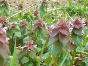
Patches of heal-all were found in the field along the creek trail

Patches of heal-all
were found in the field along the creek trail

Naturalists identified several early wildflowers and plants along the creek trail.  Georgia and Pam identified known and unknown plants with the help of Gene’s Wildflower Book.  Heal-all (self heal), cleavers (bedstraw), yellow bedstraw, nettle, red ozier dogwood, honeysuckle, plaintain, blue violets, and spring beauty were found along the field trail.

Poison Ivy Vines-004 Web

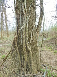
Leafless poison ivy vines, growing up a tree in the spring, was also pointed out. Hikers should be aware that these vines are not grape vines and their oils can create an unwanted contact poison.

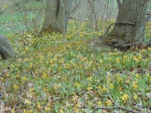
The most striking find were a very large patch of flowering adders tongue (trout lily) all along the high creek bank where the shagbark hickories and other trees meet the trail on the west side.  Everyone agreed they had never seen this many flowers blooming in one area.  Georgia indicated the flower was edible and a few were eaten, with no known side effects. Follow up research confirmed their safety.

Flowering adders tongue

Flowering adders tongue

Thanks to the Evanski’s for sharing their new home on Honeoye Lake with us and all hikers who brought outstanding dishes to pass for a relaxing social after the hike.

Stony Brook Park – Sunday May 5th @2PM

StonybrookSunday, May 5th we will be hiking at Stony Brook Park in Dansville, New York. Stony Brook State Park’s terrain comprises hilly woodlands, a deep gorge with rugged cliffs overlooking three main waterfalls and fascinating rock formations. The signature attraction of the park is the beautiful brook, which is an example of the post glacial streams in the Finger Lakes region. The small creeks and brooks in this area cut through the Great Lakes area escarpments following retreat of the ice age glaciers, creating deep, narrow gorges, many like this scenic brook, with waterfalls.

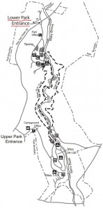
MEETING TIME & PLACE: This year Stony brook is opening early so there will be a fee of $7.00 per vehicle to enter the park. If you wish to car pool please plan to meet up at Tom & Jerri Rounsville’s by 1:40pm. Otherwise you may arrange your own car pool and meet us directly at Stony Brook Park’s lower, northern parking lot. (Refer to directions below)

Climbers The climbers beginning at Stony Brook State Park’s lower, northern, parking lot, will hike the West Rim Trail head with an elevation increase of about 400 feet. They will then connect with the East RIM Trail which will eventually loop back down to the lower parking lot where the hike began. These trails have a moderate difficulty rating, with some stairs and long steep climb at the beginning. You will take in views of the gorge and numerous waterfalls during this hike.

Tourist The Tourist beginning at Stony Brook State Park’s lower, northern, parking lot, will hike the West Perimeter Trail. They will then connect with the East RIM Trail which will eventually loop back down to the lower parking lot where the hike began. This hike starts out with a gradual but long climb and some stairs on the East RIM Trail. You will take in views of the gorge and numerous waterfalls during this hike.

Naturalists The Naturalists will meet with the Climbers and Tourists at Stony Brook State Park’s lower, northern, parking lot. They will take in some views of the Gorge before carpooling to the upper parking area for an exploration on the flatland to view various spring flowers which are in bloom along with other interesting wild life. This hike will be mainly on flat land with a few stairs to see the Gorge if you wish.

Directions

Stony Brook Park is located on NY 36 3 miles south of Dansville. You will see signs for the park entrance. Proceed up the park road until it dead ends at the lower northern parking area.

After Hike Social 

The after hike social will be held at Tom & Jerri Rounsville’s house 6286 McNeil Hill Road in Dansville. Please bring a dish to pass and BYOB or you can make a $5 donation. Tom will provide chili. To get there from Main St. in Dansville, heading south on 63 leaving town, take Sahrle Hill Road, bear left until on top of the hill, then left on Sterner until it turns into McNeil Hill Rd. Follow McNeil Hill Rd until 6286 McNeil Hill on your left just after the brown pasture fence.

Happy Hiking!  Hope to see you there!