Harriet Hollister Spencer Park

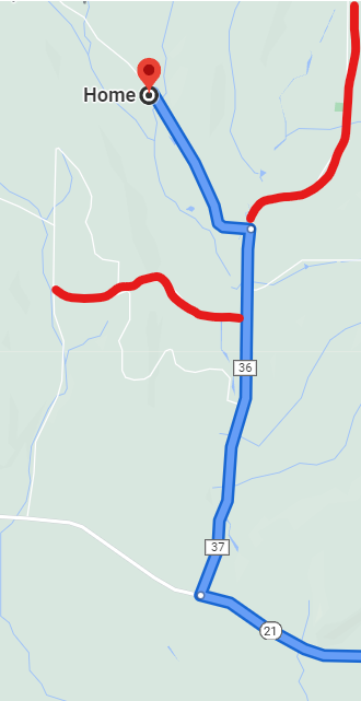
Please join us this Sunday for a cross country ski, , snowshoe or hike,  while exploring  a hiking site not far from Springwater. A few years ago New York State acquired several new parcels of land to the south of Harriet Hollister Spencer Park, linked to the main park by an established snowmobile trail called C4.In the past, we’ve hiked the section of the C4 trail closest to the main park, and this Sunday we will snowshoe and hike from the parking lot, following Ruthies trail, to Chalet trail  to C4 off Doremus trail. We will follow C4 to a point where we will turn onto a old single track hiking trail(red dashed) that crosses  the “Sidewinder” trail through the south east section of the park. we’ll follow this around and return back to the parking lot via the  single track trail  (red dash trail) which runs parallel with the overlook road.

Skiers will start out at the parking lot and may choose to take any of the many trails in the park or venture out of the main park on C4. This is a challenging  ski as there are a few uphill climbs but  finishing with a nice view out in a wide open field. Skiers can return to the main parking area by returning back on C4.

Wear proper clothing according to prevailing weather conditions . As always, bring water, skies and poles good hiking footwear, snowshoes and poles if you typically use them. The trail is gently rolling – no especially steep sections.

Social:  After the hike we will ??

Directions:  

From Springwater and Wayland – take Route 15A North from Springwater, turning right on Wheaton Hill Road. Take a left on Canadice Road (County Road 42), forking to the right when County Road 42 divides off from Canadice Lake Road. Make the next right, on Tibbals Road (formerly Town Line Road). In 1.0 miles, Take the first left onto Ross Rd. At the stop sign (2.7 miles), take a sharp right onto Canadice Hill Rd. The parking lot will be on the left in 0.8 miles..


From Rochester or Canandaigua – go to Honeoye, and follow Route 21A (Main St. Honeoye) west toward Hemlock. About a mile out of Honeoye turn left on County Road 37. Follow County Road 37 until it makes a 90 degrees turn to the right across from the Canadice Methodist Church; at this point go straight onto Canadice Hill Road instead of County Road 37. Continue straight on Canadice Hill Road, taking the left fork at Ross Road, The parking lot will be on the left in 0.8 miles..
Schribner Valley Bonfire

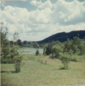
Pond from the cabin as seen in 1966.

Our Sunday hike this week will be on private property around the Schribner Valley in Springwater. In order to adjust to weather conditions on the day of the hike, the plan below may need to change. This plan has been updated to reflect the heavy snow on the ground as of Wednesday. We highly recommend snowshoes or skis to best enjoy the snow – poles will be valuable to everyone.

There will be four routes for Climbers, Tourists, Naturalists and Skiers. Hikers and snowshoers can enjoy the first three routes. The skiing trail has been marked, but will be led by a volunteer on the day of the hike.  A map will be provided, but it is important to follow the ski track to avoid getting lost.

Please note that these hikes are on private trails with various levels of maintenance. You will need to step over some recently fallen trees. With the deep snow each step should be done carefully.

All hikers will meet at our house.  There is parking available on the driveway in front of the garage, and also on the road, both around the intersection and turning to the right on Schribner.

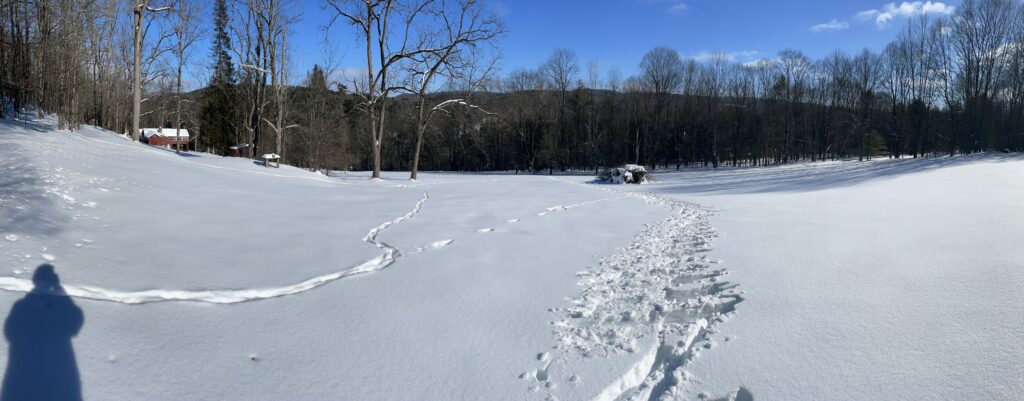
All trails will start up our open field. Follow the tracks in the snow.  When tracks cross, please continue straight across without disturbing the crossing trail so the other group can also follow their trail.

The Naturalists will head up hill along a trail near the road. Upon reaching the top of the field. A left turn will take us to a second field along a Red Pine forest planted in the early 1930s. From there, we will follow the edge of the valley to our A-frame built back in 1962 from logs cut on the property, and then by the parent White Pine which was out in an open field in the 1950s. This hike will be about 2 miles with an over elevation change of 200 feet.

The Climbers and Tourists will head up the valley, crossing onto our neighbors  property. We will curve around crossing the valley following logging trails. After returning to our woods, the climbers will turn right heading up to the top of the hill. They will definitely earn their name on this climb, but the reward will be that “its all down hill from there”. The tourists will continue straight on a more level trail.

The Skiers will also head up the field for a view. Taking advantage of gravity, they will come back down the field, then head down past the old cabins and climb up the other side of the valley.  A left turn will take them along the old farmer’s road across onto another neighbors who has given us permission to enjoy the snow.  Follow the trail as it turns right and returns on the uphill side of the woods. Another right turn will head down the hill – this will be the steepest hill on the route and likely a good time to practice carrying skis on your shoulders. From the creek, follow your tracks up and continue straight back to the house.

Following the hike, all hikers are welcome to join us around a bonfire for a dish-to-pass social. If the weather doesn’t cooperate, we will move the social inside with a fire in the stove. Please bring a dish to share, or a personal sandwich depending on your risk tolerance. Chilled drinks will be available, or bring your own beverage.

Directions:  

Warning: Schribner and Giles roads are not plowed to allow travel to our house from Strutt St in Springwater. Assuming there is ANY snow on the ground, you must come down Tabors Corners Rd to Schribner Rd. Set your GPS to “Tabors Corners and Schribner Rd, Springwater, NY“.

From Springwater: Head north on NY 15A from the light.  Take the first right onto Wheaton Hill Rd. Go all the way to the top of the hill and the stop sign at the tee.  Turn right on Wetmore Rd. At the next stop sign, turn right onto Tabors Corners Rd. In 3.5 miles turn right onto Schribner Rd.  In 1.0 miles, the driveway is on the left at the intersection between Schribner and Giles Roads.

From Wayland: Head east on NY 21 North toward N Cohocton.  In 3 miles from the light in Wayland, turn left onto (Steuben) CR 37 (Tabors Corners Rd).  In 2 miles, turn left onto Schribner Rd. In 1 mile, the driveway is on the left at the intersection between Schribner and Giles Roads.

From N Cohocton and Naples and Canandaigua: Take NY 21 South through Naples and N Cohocton toward Wayland. In 4.5 miles from the right turn in N. Cohocton, turn right onto (Steuben) CR 37 (Tabors Corners Rd). In 2 miles, turn left onto Schribner Rd. In 1 mile, the driveway is on the left at the intersection between Schribner and Giles Roads.

Genesee Valley Greenway – North from Avon

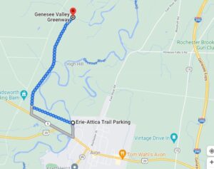
The Genesee Valley Greenway State Park is a 90-mile open space corridor that follows the route of the Genesee Valley Canal (1840-1878) and the Pennsylvania Railroad Rochester Branch (1882-1963) from the Erie Canalway Trail in Rochester’s Genesee Valley Park to the Village of Cuba in Allegany County. The Greenway will eventually extend to Hinsdale in Cattaraugus County. This Sunday’s hike will start at the Erie-Attica Trail parking area on Farmers Rd in Avon, as parking is limited at the road crossings of the Greenway itself.

All groups will do a 2 hour out-and-back hike or ski, depending on conditions.  The trail is flat for almost the entire distance, with minor hills at the trail intersection and a farm road crossing.  The Greenway is often popular with snowmobilers, which can create a rough skiing surface.

All groups will head west on the Erie-Attica Trail across the Genesee river bridge and continue for 1.1 miles to the Greenway intersection.  Several sets of bridge abutments are visible along this stretch, with the largest marking the bridge which carried the Erie-Attica Railroad over the Pennsylvania Railroad. Interested hikers may find the planning study report for the Erie-Attica Trail of interest.

All groups will turn right (north) on the Greenway and continue until the turn-around time.  The views in this area are at risk from the proposed Horseshoe Solar Array which will likely start construction soon in Caledonia and Rush.

Following the hike, join us for a social hour at The American Hotel in Lima, famous for their soup selection.

Directions to the Farmers Rd Parking Area

From Springwater: Head north on NY-15A for 18.8 miles to Lima.  Turn left at the light onto 5 & 20 and travel 7.6 miles west (through the traffic circle in Avon) to Farmers Road on the right just before the Genesee River Bridge.  Follow Farmers Rd for half a mile, passing through the underpass under the trail. The underpass may have a pool of water under it. The parking area is on the north side of the underpass.

From Naples: Head west from Naples on CR 36 for 14 miles to Route 20A in Honeoye.  Turn left and travel 1.5 miles. Turn right onto Big Tree Rd, travel 3.5 miles to Route 15A.  Turn right and continue to Lima, following Springwater directions to trail parking.

From all points north: Take Route 390 to Exit 10 (Avon).  Turn left onto Route 20 west and continue through traffic circle in Avon and to Farmers Road (3.5 miles)

The American Hotel is on the corner of Route 20 and Route 15A in Lima. Turn left at the exit from Farmers Rd and continue for 7.6 miles to the light in Lima.