Bath National Cemetery
On Sunday we will walk a loop through the historic Bath National Cemetery which will have been decorated the day before as part of the Wreaths Across America campaign. The cemetery dates back to 1877 when it was started as a burial ground for veterans who died while residing at the Grand Army of the Republic Soldiers and Sailors Home (now the VA Medical Center) in Bath. 
Following the walking tour of the cemetery (about one and a half miles round trip) those who want can hike an extra loop to downtown Bath and through the Liberty Street National Historic District and Pulteney Square Village Green (about four miles round trip). Everyone should be prepared for some hills and possible slippery footing; people doing the downtown walk should bring flashlights.
Directions and Meeting Place:
Take I-390S (Genesee Expy) towards Corning then continue on I-86 (Southern Tier Expy) to the Bath – Hammondsport exit (Exit 38). Turn right onto W Washinton Street, go a short distance and cross the bridge over the Cohocton River then turn left into the first VA parking lot. Approximately 29 miles from Springwater.
Social:
The social will be at the Mountain View Inn, 34 Main Street, Atlanta, NY
More Information:
National Park Service – Bath National Cemetery: https://www.nps.gov/nr/travel/national_cemeteries/new_york/Bath_National_Cemetery.html
Wreaths Across America: https://wreathsacrossamerica.org/
National Park Service – New York State Soldiers & Sailors Home: https://www.nps.gov/places/bath-branch-bath-new-york.htm
Liberty Street National Historic District: https://en.wikipedia.org/wiki/Liberty_Street_Historic_District_(Bath,_New_York)
Other:
Those wanting to carpool can meet in Wayland behind the Fire Station – plan to be ready to leave at 1:15, to get us to the parking lot at 1:45.
There are no public bathrooms at the VA Hospital or National Cemetery.
High Falls Riverwalk
Canadice Lake Trail Ride or Hike
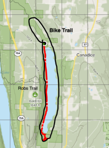
We will meet in the parking lot at the north end of Canandice Lake that is on Purcell Hill Rd and will divide into two groups, Hikers and Bikers.
Hikers –
This hike offers a little of everything, and hikers can choose the difficulty level and pace that is best for them. The Canandice Lake Trail is an 8.4-mile out-and-back. Generally considered an easy route, it takes an average of 2h 35min to complete. This is a popular trail for birding, hiking, and walking. For the more adventurous; about 2 miles into the hike, you come to Robs Trail, which is a steep incline that brings you up the side hill to Rt. 15A. The round trip for this portion of Robs Trail is 2.9 miles out and back and takes about an hour and a half.
Bikers–
This is an enjoyable 10.5 mile ride around Canandice Lake. There is only one moderate hill at the very beginning of the ride. Bikers will take a left out of the parking lot onto Purcell Hill Rd. and take the first right onto Canandice Hollow Rd. This road eventually winds around to the right and reaches Canandice Lake Rd. We will follow Canandice Lake Rd. all the way to the South end of the lake where we will make a right onto the Canandice Lake Hiking/Biking trail which runs along the west side of the lake back to the parking lot.
Social
Following the hike will be a Social at the Hemlock Lake Park please bring a dish to share. In case of weather that may make an outdoor social uncomfortable, please check the website on Sunday morning for an update on the social. Warmer alternatives include the Birdhouse Brewing on Main St. in Honeoye, NY
Directions-
Coming from the South – take 15A north and make a right onto Purcell Hill Rd. Parking will be on your right towards the bottom of the hill almost to Canandice Lake Rd.
Coming from the North – take 15A south and make a left onto Purcell Hill Rd. Parking will be on your right towards the bottom of the hill almost to Canandice Lake Rd.

