Hemlock Lakeshore / Rob’s Trail Hike

The water in Hemlock Lake is very low at the moment and a wide swath of beach is exposed. We will take advantage of the unusual conditions to walk a few miles to the south and back on this Sunday hike. The beach is generally 12-15 feet wide and varies between stony and rough stone chips. It will be a slow and careful walk but there’s plenty to see along the way and the lake and the late autumn woods on the opposite shore are very scenic. For those who prefer the easier dirt road parallel to the shoreline, there are several points to switch back and forth between the beach and the road. As a bow hunting season precaution, please wear some red or orange outerwear.

Meet at the north boat launch, at the end of the old east lake road, a sharp left after you first enter Rix Hill Road from Route 15A.  This will be an out and back hike; we will all start out with a group on the beach and a group on the shore. All hikers may return at any time they are ready, or switch between groups at about the one mile point or about the two mile point. Ambitious hikers may want to head partway up Rob’s Trail after about 3 miles, where it veers to the east and up the hill.

Optional Social: Please join us at the Birdhouse Brewing Company in Honeoye – 8716 Main Street, just east of the traffic light, for craft beer and pub food.

Directions: From Springwater: proceed north on Route 15A 19 miles, then make a left on Rix Hill Road and an immediate left on Old East Lake Road, a.k.a Boat Launch Road.

From Honeoye and points east:  Take Route 20A west from the Bristol Valley and Honeoye. When 20A meets Route 15A, make a left and go about .6 miles to Rix Hill Road. Make a right and then an immediate left on the dead end road to the boat launch parking area in one mile.

From Rochester and points west: Take Route 15 south from Henrietta or Route 15A south from Honeoye Falls, or Route 390 south to the Lakeville-Livonia exit, then go south on Route 15 and then east on Route 20A  through Hemlock. When Route 20A turns east toward Honeoye, go straight another .6 miles and make a right on Rix Hill Road. Then make an immediate left onto the boat launch road and go to the end, 1 mile.

From Penn Yan:  Take 54A across the north end of Keuka Lake to Branchport. Continue straight onto Italy Hill Rd (CR32). In 4.9 miles, turn left to stay on Italy Hill Rd and take the 2nd right onto Italy Hill Turnpike (CR34). At the bottom of the hill (3 miles) stay to the left onto Italy Valley Rd (CR18). On entering Ontario County, Italy Valley Rd becomes CR21. Continue to the T and turn right onto NY 53 into Naples. Continue straight onto NY 21 North past the Wayside Market and turn left onto Clark St (CR 36). Continue for about 15 miles along Honeoye Lake. Turn left at the light onto US 20A. In 4.8 miles, turn At 0.7miles past the intersection with 20A, take the first right onto Rix Hill Rd into the Hemlock Lake Park. Take the first left and follow the boat launch road to the end.

To the Social: From the Boat Launch parking area, return to Rix Hill Road, make a right and then a left on Route 15A. Go .6 miles and make a right on Route 20A. In about 4.75 miles you will reach the traffic light in Honeoye. A few buildings beyond the light is Birdhouse Brewing on the left at #8716.

 

Stony Brook Park

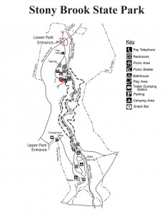
LOCATION:  Enter the park through the North Entrance off of NY-36 and drive past the admission gate (this is considered “off-season” so no fees will be charged) to the parking area.  We will start our hikes from the Clara Barton Shelter which is to the left of the parking area.  Bathrooms near the shelter will be open.

HIKE DESCRIPTION:  Stony Brook is one of the Finger Lakes State Parks which was the site of a Civil Conservation Corps camp during the 1930’s.  Many of the trails and facilities at the park are thanks to the work that they did. We will hike on three trails that cover the length of the park – the Gorge Trail, West Rim Trail and East Rim Trail.  The Gorge Trail runs along Stony Brook at creek level while the other two trails wind along the top of the gorge.  Hikers will appreciate the work done this past summer to replace stone steps and wooden stairs where needed.  We will split into three groups with each group walking at their own pace.  All three trails have many steps and are most likely going to be wet and slippery so poles and traction devices or good treaded hiking boots are recommended.

Climbers Will hike the Gorge Trail and return on the East Rim Trail. They will cross over the stone bridge located about 500ft from the Gorge Trail Exit returning on the East Rim Trailhead and continue following the trail back down to the Clara Barton Shelter.

Tourists  They will go past the swimming area to the Gorge Trail trailhead and continue up past three waterfalls to the upper park  and return back to the lower park on the East Rim Trail.

Naturalists will hike the Gorge Trail out and back.  They will go past the swimming area to the Gorge Trail trailhead and continue as far as they want then return by the same route.

RECOMMENDATIONS: Hiking poles would be recommended.

SOCIAL:  An after hike social will be at the Clara Barton Shelter. Hot dogs will be provided.   Bring a dish to pass or a 5 dollar donation would be appreciated.

DIRECTIONS:  From the Village of Dansville take NY-36 South.  The North Entrance to Stony Brook State Park is several miles south of the village on the left.

Leave a Reply

Honeoye Valley Hike

We are looking forward to hosting a hike on October 27th. The meeting point will be 9181 Ashley Rd, Livonia, NY at 1:45. We will gather and then proceed on the hike which will start out flat, going through a wooded area and then we will climb a hill for a beautiful view before heading back. The trail through the woods can be muddy at times.  The social is a dish to pass at our home after the hike.

Directions-  Ashley road runs between County road 37 and Reed road.  Ashley road is also the only road off of county road 37 between 20A (Valley Inn is in the corner) and Richmond Mills Road. If heading south from Rochester it will be a right, if heading north from the Valley Inn it will be a left. We will be the first house past White Road in the left.

Hi Tor Hike

This Sunday’s hike at High Tor Wildlife Management Area in Naples will take us back to many of our previous hikes including:

  • a hike by Springwater Parks and Trails at least one and a half decades ago
  • a winter hike just before Covid hit
  • and a follow-up to our maintenance hike on the Blue trail three weeks ago.

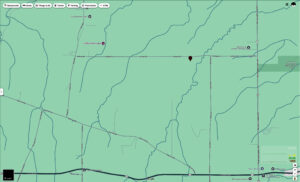
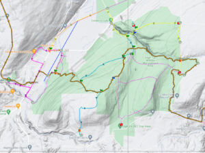
We will all meet at the DEC parking area on Basset Rd near the west end of the road (See the map to the right).  Please arrive in time to start the hike at 2:00 PM. We will have two hikes based on distance.  Hike leaders may adjust the hikes to accommodate our hikers and the weather. Please note: in the following hike descriptions, the term road refers to the maintenance road, which  is more accurately called a wide trail.

All hikers will start on the same trail out of the parking area. The Naturalists will take the left route and follow the maintenance road up to the BHB orange trail. Turning left onto the BHB (orange blazes) they will quickly come to the pond and will explore the shore of that. Returning on the BHB to the maintenance road, the Naturalists will follow their own footsteps back to the cars.

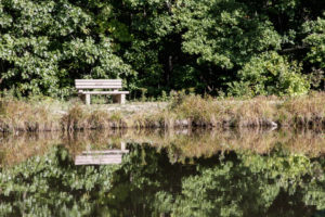
The Finger Lakes Trail from Naples to Parrish Gully. The Howard Beye memorial bench.

The Tourists will join the Naturalists up to the BHB orange intersection. The Tourists will continue straight on the maintenance road to the lean-to and overlook of Canandaigua Lake. Returning on the road, they will retrace their steps to the point where the BHB turns right. The tourists will continue straight (not on the BHB) south to the cars. They will likely meet up with the Naturalist on the final leg and will then return together to the cars.

The Climbers will also take the same route as the Naturalists. When they reach the BHB orange trail, the will turn left and continue around the pond. The Blue trail will break off to the right and the Climbers will follow that down to the Finger Lakes Community College property on East Hill Rd. Climbers are welcome to bring small clippers to do minor maintenance on the trail as we go.  We will station a couple of cars at the final parking lot to ride back to the start point.

Following the hike, please join us for a social at Kelley’s home in Atlanta (NY).  See directions below.

Directions:

From Naples: Take NY 53 south from Naples for 1.1 miles. Turn left onto Italy Valley Rd (CR 21) for 2.1 miles. Turn left onto Basset Rd, when the main road takes a sharp right turn. Parking is on the left in 0.2 miles.

Additional directions are available here.

Directions To Kelly’s in Atlanta: Return to Naples by going right out of the parking area, then right onto Italy Valley Rd, then right onto NY-53 N. In 1.3 miles, turn left onto NY-21 S. In 4.5 miles, in N. Cohocton, turn right to stay on NY – 21. Take the next left onto University Ave. In 0.4 miles, Kelly’s home is the second house after the farmer’s field on the right.