Rob’s Trail

Please join us for a hike on Robs Trail. For this hike, we will take advantage of portions of Rob’s Trail on both the Hemlock and the Canadice sides of route 15A. There are two parking lots for Rob’s trail at the top of Bald Hill, so pay attention and meet at the parking lot that is located on Old Bald Hill Rd South. Don’t come to the parking lot directly on Rt 15A. See directions below.

The Tourists and Climbers will head west from the parking area and head across 15A to the trial. This trail will join the trail from the Hemlock side parking lot in about 1000 ft. We will continue down the trail to Hemlock Lake. At this point, the climbers will take a few minutes to walk out to the lake and rest while enjoying the beach, before returning to the trail and retracing the route back up the hill to the cars. Meanwhile, the Tourists will continue on the flat portion of the trail out to the north boat launch and pre-staged cars that will ferry hikers back to the cars at the start of the hike.

The Naturalists will head east from the parking lot and will explore the Rob’s Trail loop around the top loop of Rob’s trail. At about the mid-point, the is a bench and a branch trail that heads down the hill to Canadice Lake. On this hike, the Naturalists won’t take the steep trail down the hill, but will continue straight around the loop and back to the cars.

Following the hike, please join us for a pot-luck social at Hemlock Park at the North end of Hemlock Lake. Bring a dish to pass and your own beverage. Or donate $5 to the social fund.

For a more detailed description of Rob’s trail, check out their website.

Directions to the trailhead: 

From Springwater:  Take Rt 15A north.  In 5.9 miles north from the flashing light in Springwater, take a sharp right turn onto Old Bald Hill Rd S. The parking lot is on the left almost immediately. Just a reminder – don’t park on the left side of Rt 15A because we aren’t meeting there.

From Hemlock: Take Rt 15A south.  At 4.9 miles south of the 20A/15A intersection south of Hemlock, take a slight left onto Old Bald Hill Rd S. The parking lot is on the left almost immediately. Just a reminder – don’t park on the right side of Rt 15A because we aren’t meeting there.

From Honeoye. Take US-20A west. Turn left onto NY 15A about 4 miles past CR 37. In 4.9 miles south of the 20A/15A intersection take a slight left onto Old Bald Hill Rd S. The parking lot is on the left almost immediately. Just a reminder – don’t park on the right side of Rt 15A because we aren’t meeting there.

From Canandaigua: Take Bristol St from Main St in Canandaigua to the intersection of US 20 and NY 21. Continue straight across US 20 onto NY 21. Continue straight again onto CR 32. In 3.9 miles from US 20, take a slight right onto Fisher Hill Rd, then (after 0.4 mi) a left onto Vincent Hill Rd. In 1.9 miles turn left onto US 20A. Turn right to stay on US 20A, through Honeoye to a left onto NY 15A. In 4.9 miles south of the 20A/15A intersection take a slight left onto Old Bald Hill Rd S. The parking lot is on the left almost immediately. Just a reminder – don’t park on the right side of Rt 15A because we aren’t meeting there.

Direction to the Social from Old Bald Hill Rd S. Turn right out of the parking lot, then right onto NY 15A. In 4.2 Miles, turn left onto Rix Hill Rd.  The park is the third left in 0.1 miles.

Dansville Reservoir and Gully Preserve

We are going to hit 2 gems this week.  We are going to start at the Dansville Reservoir, Reservoir Rd, Dansville.  We will park along Reservoir Road.  This is a pretty open hike with minimal coverage so be sure to where a sun hat or wear plenty of sunscreen.   Once we explore the shoreline we will carpool just around the corner to Gully Preserve on Whitman Gully Rd.  There we can explore 2 trails, with one having a water crossing so wear shoes that can get wet!  It’s a somewhat wide crossing with 2-4 inches of running water.
We will be staying in one group for this hike – sorry climbers this won’t be much a challenge but if you want peace and serenity this is your hike.
Our social will be at the Gully Preserve so bring a blanket or chairs to sit on and a dish to pass.  If it’s inclement weather we will have the social at the Sunrise Restaurant.
From the North/Dansville – head south on 63 out of Dansville, heading towards Wayland.  Turn left onto Reservoir Rd and follow to Reservoir.
From South/Naples – head south on 21 towards Wayland.  Keep on 63 south once in Wayland and turn right onto Reservoir Rd, follow to Reservoir.

Deusenbery Trails to the Hamlet of Atlanta following the Old Erie Railroad Tracks

Our hike Sunday June 4, 2023, starts at 4pm (please arrive by 3:45 to carpool to our starting point).  This is a one-way hike around farm fields, following trails through sections of woodlands, continuing along paths beside the Cohocton River to the Old Erie Railroad bed ending in the Hamlet of Atlanta. We will meet at our ending point in Atlanta.  Across the street from the E J Cottrell Library, 3 Beecher Street, Atlanta.  Look for the Springwater Trail’s parking sign.

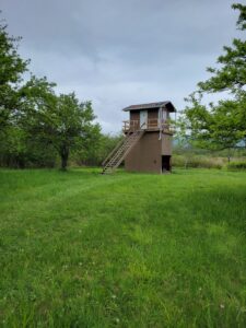
Most of this is private land except for portions of the Railroad beds that the DEC have for fishing access.  We will drop the Naturalist off on Parks Road to begin their flat hike down the Old Erie Railroad Bed for 1.5 miles.  If they finish before the rest of the group, they can tour the Clark property which is forever in a wetland reserve.  There are trails throughout the property that you can follow.  Check out the Birdhouse for a bird’s view of the river, hiking paths and wildlife.  If by chance you prefer to just tour the wetlands that is also an option by starting at the parking lot, walking a short distance up the Old Erie Railroad bed and entering the reserve.  The first entrance on your right will have trails throughout the reserve.  The 2nd entrance will be the home of the Birdhouse which you are welcome to climb and see the views.
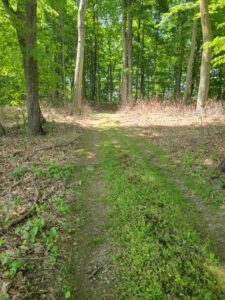
The Tourists and Climbers will start downhill together before the Tourists change directions through a short uphill climb through a sugarbush to the crossing of the Cohocton River.  They will then work their way around the headlands to the Old Erie Railroad bed, flat terrain, for a total of 3.25 miles.

The Climbers will head off for an up and down trail through the woods to the flat path along the Cohocton River.  Once they cross the river, they will follow the headlands to the Old Erie Railroad bed for a total of 4.25 miles.

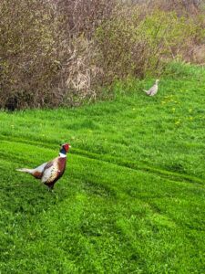
We might even be lucky to see Fred and Francis down by the river.


DIRECTIONS

From Springwater: take Route 15S to Wayland for 4.9 miles.  At the light in Wayland turn left onto Route 21N, drive 5.9 miles to Beecher Street.  Continue on Beecher Street for .5 miles with parking on the right.  Watch for the Springwater Trail sign.

From Naples: take Route 21S to North Cohocton.  Turn right to stay on 21S.  Go .8 miles turn left onto Beecher Street.  Continue on Beecher Street for .5 miles with parking on the right. Watch for the Springwater Trail sign.


The Social will be at the Mt. View Inn at 34 Main Street in Atlanta.

Stid Hill Hike

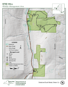
The Stid Hill Multiple Use Area is a 847 acre tract of land situated in the townships of Bristol and South Bristol in Ontario County. It is bHiking trails at Stid Hill WMA in Bristol, NYounded by Route 64 on the west and Dugway Road on the north. Ganargua Creek, better known as Mud Creek, flows along Route 64. At one time, Stid Hill was productive sheep and cattle grazing land. Today the grazing has been eliminated. The mixture of steep hills, ravines, gullies, gorges, woods, and open areas create scenic vistas and also provide varied wildlife habitats.

Sunday May 28, 2023 we will all meet at the Stid Hill MUA parking area on Rt. 64 at 1:45pm.  At this meeting point we will divide into groups.  Climbers will carpool to Dugway Rd. and hike back down to Rt. 64.  The Tourists and Naturalists will follow the trails from this access point on Rt. 64.  The ground is uneven so you may want to bring poles.  There may also be very wet and muddy spots along the trail so waterproof hiking shoes or boots would be recommended.   

The Meeting Place

We will all meet at the Stid Hill MUA parking area on Rt. 64 at 1:45pm. This parking area is for the northern portion of the Stid Hill area.  It is after Bristol Mountain ski area if coming from Naples, and after Dugway Rd if coming from 5&20 or 20A.

Getting There

Route 64 runs north-south, so there are only two directions of approach.

From the north, (Honeoye and Bloomfield) starting at Route 5 & 20 in Bloomfield, come down Route 64,  past Bristol Center and CR32. 4.8 miles past the intersection with 20A, the parking area will be on your left.  If you reach Bristol Mountain Ski Area you have gone too far.

From the south, starting at Bristol Springs head north on Route 64 past Bristol Mountain Ski Area for 1.4 miles, and the big wooden sign that says Stid Hill, you will then see the parking area on your right. If you come to Dugway Road or Bristol Center you’ve come too far north.

From Springwater, Google Maps recommends heading north to 20A through Honeoye, then south on 64 for 4.8 miles. The parking area will be on your left.

The Social

Will be at Lock Stock and Barrel on Route 64 just north of Bristol Mountain  and south of the Stid Hill Hike parking lot.