Hemlock Lakeshore Hike

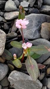
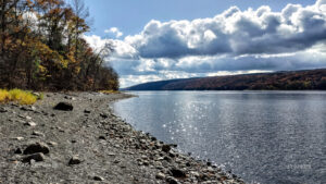
The water in Hemlock Lake is very low at the moment and a wide swathe of beach is exposed. We will take advantage of the unusual conditions to walk as much of beach as we can on this Sunday hike. The beach is generally 12-15 feet wide and varies between stony and rough stone chips. It will be a slow and careful walk but there’s plenty to see along the way and the lake and the late autumn woods on the opposite shore are very scenic. Wildflowers are scarce in November, but there are tiny pink and yellow flowers growing in the shelter of the stones.
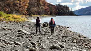
 

Meet at 1:45 at the north boat launch, south of the eastern edge of Hemlock Lake State Park.  There’s a generous parking lot there and easy access down to the exposed beach.  This is necessarily an out-and-back hike, so all groups will walk south together and anyone can turn around at any time. The beach follows the path of Rob’s Trail just a few feet away in the woods, and there are lots of places where walkers can switch between the beach and Rob’s Trail. All groups will walk south together and the naturalists and tourists can turn around whenever they feels it’s the right time.


The Social
The social will be a dish-to-pass picnic at Jane Affolter’s farmhouse at 5422 County Road 37


Directionsfrom Springwater: Head north on NY-15A. At the end of Hemlock Lake, turn left on Rix Hill Road. Almost immediately turn left on to Old East Lake Road, go past the Rochester City water treatment plant and continue on Old East Lake Road until you come to the boat launch parking lot.

Directionsfrom Canandaigua, Honeoye and points east: From Honeoye, continue west on Main Street (Route 21A) to Route 15A in Hemlock. Make a left, go a half mile, and take a right on Rix Hill Road. Almost immediately turn left on to Old East Lake Road, go past the Rochester City water treatment plant and continue on Old East Lake Road until you come to the boat launch parking lot.

Directions from north and west: Take Route 390 south to Exit 9 (Lakeville-Livonia). Go south on Route 15 into Livonia, the southeast on 20 A. Make a right after 3.9 miles on County Road 56 (Federal Road),  then a left on Adams Road after .6 miles. Take the second right on Blank Road. In a mile, fork left at Rix Hill Road and almost immediately turn left on to Old East Lake Road, go past the Rochester City water treatment plant and continue on Old East Lake Road until you come to the boat launch parking lot.
 

Wesley Hill Preserve

Maintained by the Finger Lakes Land Trust, Wesley Hill Nature Preserve is a 390-acre protected area featuring diverse stands of mature forest, a wide array of wildflowers, sweeping vistas of the hills surrounding Honeoye Lake, and a dramatic view of Briggs Gully. Over 5 miles of trails offer hours of hiking, skiing, and exploring for enthusiasts of all levels.

We will explore the Red and Green Trails.  Please wear Blaze Orange if you have it or another bright color.  

Address: 6280 Gulick Road, Naples    Entrance/Parking is North of Cumming Nature Center

From Finger Lakes Land Trust web site: (During the full hunting season, from October 1 – December 19, the majority of the preserve and hiking trails will remain open to the public, including the area of the preserve lying west of the cabin and to the overlook (at the yellow/blue trail junction, west of the orange/yellow trail junction). The yellow and blue trails accessed from Wesley Road will be closed to the public to allow for bow hunting in a section of the preserve.

Map of Wesley Hill Preserve – https://www.fllt.org/wp-content/uploads/2015/02/Preserve-Brochure-Wesley-3.pdf

The Social will be a potluck/dish to pass at Kelly’s home, 36 University Avenue, Atlanta. See directions below. Bring your our own beverage and a favorite dish to share, or contribute $5 to our social fund. 


Directions to Wesley Hill Preserve, Gulick Road parking area:

From Honeoye: take route 20A east through Honeoye to East Lake Road (CR 33). Turn right onto East Lake Road. (If coming from Bristol or points east, it’s a left onto East Lake Road).  Take the first left, staying on CR 33, then the first right onto Pinewood Hill which becomes Gulick Road. Travel about 5 miles to Wesley Hill Parking Area on the right side. Parking lot can fit about 16 vehicles; any late comers can park on the side of the road.

From Springwater: Head north on Rte. 15A toward Hemlock.  Just before Hemlock, turn right on Rte. 20A.  Follow Rt 20A to Honeoye and then follow the directions above.

From Naples: From the southern end of Naples, head west on Co Rd 36. Follow Co Rd 36 for 1.2 miles to the first right turn on Gulick Rd.  Follow Gulick for about 7 miles, past Cumming Nature Center.  The parking area is on the left.

Directions to Social:  Leaving the parking lot on Gulick Rd, head South to Hunt Hollow Rd/County Rt 36.  Turn Right onto Hunt Hollow Rd.  Take a short distance to Maxfield Rd and turn left.  Follow Maxfield to Eelpot Rd and turn Right.  Follow Eelpot to Route 21 and turn Right.  Follow 21 as if going to Wayland, making the right turn in N Cohocton at Mikey’s Mini Mart, then make your first left onto University Ave.  The house is the 2nd home on the right past the Fire House.  Please park on the street or in the left side yard via the dirt drive.  Leave the gravel drive open as I’ll have everyone enter through the back door/mud room. 


Hunters of the Hen of the Woods

APPRECIATING ENDLESS FORMS – September 24, 2023 – By D. Randy Weidner

Like many things in the natural world, the fruiting of mushrooms have a season. Lest you think that now you will learn exactly when to go out and find a particular species of wild mushroom, I am sorry to disappoint. I have long been interested in the fruiting phenology of fungi, and for some time kept careful logs of when I found what mushrooms. I did this with the half selfish idea that it would help make my mushroom foraging easier in my dotage. What actually happened was that the timing of when I found certain species has changed significantly over time.

Morels in our area always fruited in later May, with the 18th being the most productive day. Lately, I find some significantly earlier. August and September were the traditional months for finding the greatest variety of species, and that may still be so, but the range is now clearly July through October. Chanterelles that used to be best around August 1, now fruit in June. Many fall fruiting fungi are still dependably found later in the season; but the dates of ‘later’ are changing.

It is easy to say that climate change is the factor; but there was always much more than temperature involved. The one factor I felt supremely confident about was the effect of rainfall. Many years ago, I read an article in the bulletin of the Boston Mycological Club, one of the oldest amateur mycological associations in the country, that stated if an area received 4 inches of rain over a short period, followed by an inch of rain per week over three successive weeks, there should be good continuous fruiting of mushrooms in summer and fall. I had always found that to be true, until this year. Now I am not so sure.

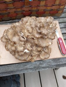
Given this unpredictability of mushroom fruiting, I am more often disappointed visiting my best spots at the times I expect to find mushrooms. I did well this year with chanterelles, but missed many summer mushrooms and some late summer species, disappointedly finding Chicken of the Woods (Laetiporus sulfureus), and Herricium species like Lion’s Mane and Bears Tooth, too old and dry for eating. So, as the season for Hen of the Woods (aka Maitake, Grifola frondosa) drew near, I visited my old spots more often. Less than a week after checking a known productive oak stump and finding nothing, I returned and harvested a two pound pristine specimen.

With Hen of the Woods, finding a fruiting specimen is worth remembering the location. Conditions being right, whatever that now means, the fungus will fruit yearly in that location for a few years before the mycelium producing the fruiting body exhausts the supply of nutrients it was getting from the host, and dies out. Not only is this a delicious mushroom, it often fruits in good quantity, from the same place for a while, and is a very distinctive fungus, not likely confused with anything toxic.

In harvesting my Hen of the Woods, I carefully cut across the base of the large fungus and placed it in a paper bag. I noticed the cut thick stem of compact mycelium had a few holes about the diameter of a pencil. At home, removing the fungus from the bag, an attractive black and red Cross- toothed Rove Beetle (Oxyporus rufipennis) fell out. Anyone who harvests wild mushrooms often finds invertebrates living on and in the mushrooms, something to cut out or brush off, along with other forest debris, before eating. No surprise there. Cutting up the fungus revealed those holes were tubular tunnels and a few more beetles were hiding inside.

These Cross-toothed Rove Beetles are one of several beetle species living exclusively in fungi. The tunnels are made by the adults as they eat their way through. Adults construct brood chambers in which to mate and lay eggs, which rapidly hatch into beetle grubs that also eat the fungus. These beetles have several very characteristic anatomical features including bead-like antennae, large jagged mandibles for cutting through fungal tissue, and a distinctive labial palpomere, a sensing organ they use to locate fungi.

I have been hunting and eating wild fungi for over 50 years, an old, but not bold, mushroom eater. My time at this activity may seem fairly long, but fossilized in amber from Myanmar, are rove beetles with nearly identical anatomy to present-day Oxyporus species, dating from about 100 million years ago, around the same time mushrooms are assumed to have arisen. So, with competition this long and successful, I am happy for every good mushroom I can get before those other hunters find them.

Scottsville Hike and Bike on the Greenway

This Sunday we will return to the Genesee Valley Greenway (GVG) for a bike or hike on a section of the trail that is farther north than we have hiked in the past. We will meet close to the northern border of Livingston County with Monroe County.

Notice:

The Hometown Event published in Friday’s PennySaver was a week early. This Sunday we will be hiking the Greenway. Join us next week, October 8th, 2023, for a hike on Rob’s Trail in Hemlock.

All hikers  and bikers will meet at 1:45 (for a 2:00 start) at the Lehigh Valley Trail parking area on West River Rd between Avon and Scottsville. This parking area is across the street from the Livingston Office Park located at 96 W River Rd and just a few feet north of the River Road Transfer Station driveway..

The Tourist/Climber hikers who would like a three mile or more flat hike will carpool 2.4 miles north to Canawaugus Park in Scottsville. From that parking area, we will find the GVG at the east end of the parking area and turn right to head back south to the Wadsworth Junction with the Lehigh Valley Trail. A left turn will take us across the Genesee River. Based on available time, the group will hike as far as time permits along the Lehigh Valley Trail timing things to return to the GVG at about 3:45, allowing 15 minutes for the final half mile on the Lehigh Valley Trail back to the cars.

Meanwhile, the Naturalists and any other hikers who would prefer an out and back hike will follow the Lehigh Valley Trail east to the GVG at the Wadsworth Junction. From there, we will head north of the GVG. After an hour (or when we meet the Tourist/Climbers group), we will turn around and return to the cars.

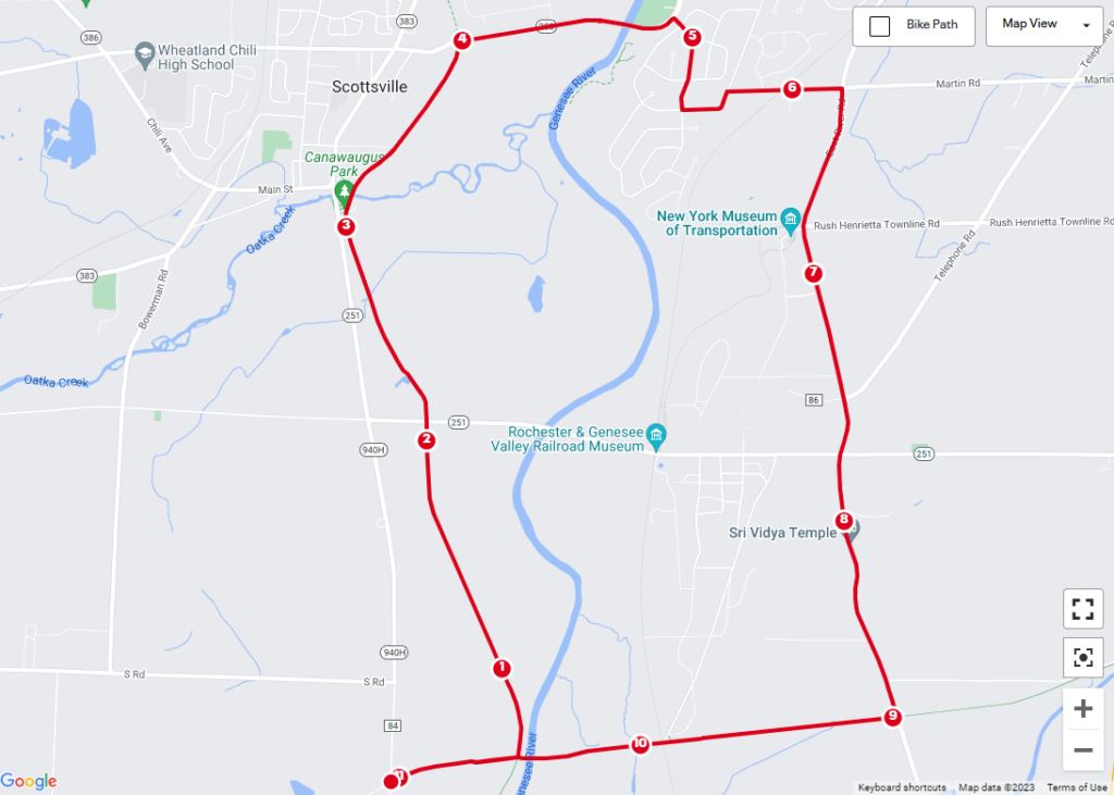
Finally, the bikers (who should arrive around 1:45 to unload their bikes) will head east on the Lehigh Valley Trail.  At the Wadsworth Junction, we will turn left onto the GVG and ride north through the Canawaugus Park. We will regroup at the NY-253 crossing to evaluate our route back to the cars.  The map above shows a route east on 253 for a mile to a right turn into Harrogate Crossing. We will explore the neighborhood (turn left on Longton Pl, left on Westcombe Park and right on Martin Rd) to get to East River Rd. We will pass the New York Museum of Transportation and continue past NY 251 until we come to the Lehigh Valley Trail. From there it is 2 miles to the cars for a total ride of 11 miles. My pre-ride took 1 1/4 hours (an average of 9.2 mph). I expect we will spend a bit more time enjoying the scenery.

This trail is currently in excellent condition. The initial segment of the Lehigh Valley Trail has some erosion as it slopes down. Bikers should take this slowly to avoid getting caught in the erosion. The main Greenway headed north is crushed stone which is very smooth. Occasional walnuts on the trail and stop signs at tractor crossing will keep bikers alert. The bikers will ride on NY-253 with wide shoulders and E River Rd with good shoulders until we cross NY 251. There is one railroad crossing on 253 where all bikers will want to cross perpendicular to the tracks. The more narrow shoulders on E River Rd after 251 will require us to share the lane with the occasional car.  Finally, the Lehigh Valley Trail from E River Rd to the Wadsworth Junction is level dirt, only slightly rougher than the crushed stone.

Social: Following the ride and hike, we will gather for a social at the Mortalis Brewing Company.

Directions to the trailhead:

From Springwater:  Take NY-15A north to Lima. Turn left on 5 & 20. You will cross I-390, and NY-15, go around the circle in Avon, and cross the Genesee River. Stay straight on NY-5 when US-20 turns to the left. You will cross the Greenway and then turn right onto CR 84 (W River Rd). In 4.3 miles, the parking area will be on the right.

Alternatively from Springwater: Take NY-15 north for 22 miles through Livonia and Lakeville. Turn left onto 5&20, staying on NY-5 when US-20 turns left after Avon. You will cross the Greenway and then turn right onto CR 84 (W River Rd). In 4.3 miles, the parking area will be on the right.

From Dansville: Take I-390 north for 29 miles to exit 10. Turn left onto 5&20, staying on NY-5 when US-20 turns left after Avon. You will cross the Greenway and then turn right onto CR 84 (W River Rd). In 4.3 miles, the parking area will be on the right.

From Naples: Take CR 36 north for 14 miles to Honeoye. Turn left on US-20A for 4.8 miles Hemlock. Turn north on NY-15A to Lima. Turn left onto 5&20, staying on NY-5 when US-20 turns left after Avon. You will cross the Greenway and then turn right onto CR 84 (W River Rd). In 4.3 miles, the parking area will be on the right.

From Canandaigua: Take 5&20 west for 25 miles, staying on NY-5 when US-20 turns left after Avon. You will cross the Greenway and then turn right onto CR 84 (W River Rd). In 4.3 miles, the parking area will be on the right. (Google maps says you can save 2 minutes by going north and taking the Thruway).