Posted on by

Naples History Village Tour

Over the years we have enjoyed many hikes in the hills and ravines surrounding the Village of Naples; this Sunday we will take a tour of historical sites in the village. Town Historian John Murphy has kindly agreed to be our guide.  We will meet at 2pm in the municipal parking lot behind the buildings on the west side of Main Street.  Nearby are the Historical Society’s Morgan Hose Building and the Old Mill.  We will move to Main Street and then north past the Maxfield Inn, Memorial Town Hall and on to the Cleveland House at the end of the village.  The Hose Building and the 1794 Cleveland House will be open.  Also, we can visit other sites such as the Indian and Pioneer burial ground.

People can either walk or car pool to the various stops along the way – it will be several miles round trip.  In addition to dressing for the weather, if it looks like rain – you may want to have an umbrella with you.  Don’t forget that daylight savings time begins on Sunday.

Our after hike social will be at The Hollerhorn Distillery, 8443 Spirit Run, Naples, NY 14512.

Directions

From Springwater, Wayland and Dansville: Take NY 15 S or NY 63 S to Wayland. From Wayland, head east on NY 21 N through N. Cohocton to Naples. Turn left on S Main St (Naples) to stay on NY 21 at Wilcox Lumber. In 0.6 miles turn left onto Mill St just past the Naples Hotel. The parking lot is behind the Hotel on your right.

From Canandaigua: Take NY 21 S to Naples. After the High School, take the third left onto Mill St. The parking lot is behind the Naples Hotel on your right.

Posted on by

Honeoye Lakeview Hike

 Update on trail conditions,  Saturday 2-29:  The trail we will follow has a base of 1-3 inches of packed snow and 3-5 inches of fresh powder on top – excellent conditions for boots, snow shoes and XC skis. The first half of the hike will be on trails which have been partly packed down by snowmobiles. For the second half in the Climber hike, there is some road walking and some hiking through untrodden snow.  Snowshoes will make the walking easier in some places, but you may want to remove them for other parts. but it’s all OK with just boots. The end of the hike is a c. 200 foot slope down through a field – perfect for ski enthusiasts.
This Sunday we will explore the woods and fields overlooking Honeoye Lake on the west side, followed by a dish-to-pass social at the Affolter farm.  Meet at 1:45 at 5422 County Road 37, about 2 miles south of Route 20A and 2 miles north of Canadice Town Hall.  Park in the drive or on the road shoulder. Our hikes will take us up the ridge, through wooded trails and along gully rims.  Get a scenic vista of the whole expanse of Honeoye Lake, from a new and different perspective.

Climbers will head northwest from County Road 37 through the woods toward Howcroft Road to make a loop of about 3 miles.  Tourists and Naturalists will start out on the same route, but with a slower pace on the initial uphill climb, and will complete a smaller loop of about 2.5 miles.  Hiking conditions are good; skis, snowshoes, and boots will all work.

Social: Bring your favorite goodies along for our social at 5422 County Road 37.

Directions: 

From Springwater, take Route 15A north 2.7 miles to a right on Johnson Hill Road.  In 1.1 miles, make a left on County Road 37. Continue northeast for 6.7 miles, including a turn to the left after Canadice Town Hall.  #5422 will be on your left, just before you leave the town of Canadice and about a half mile after you pass Hayward Hill Road and Jersey Hill Road.  Driveway has a large red barn and silo to the north.

From Honeoye/Hemlock:  Take Route 20A east from Hemlock or west from Honeoye to the intersection with County Road 37. Go south approximately 1.9 miles. #5422 will be on the right, with a red barn and white silo, just past the Entering Town of Canadice sign.

Posted on by

Genesee Valley Greenway Series

We have two changes to today’s hike:

  1. We will avoid carpooling by all meeting at York Landing and doing an out and back hike.
  2. We will cancel the social. Some hikers may choose to stop at the brewery for a pint or a growler.

Two months we hiked and skied along the Greenway from Piffard to York Landing. This Sunday we will continue North along the Genesee River to Fowlerville Rd and beyond. Well, actually for logistic reasons we are going to start at Fowlerville Rd and walk south, but you get the idea.

The Greenway follows an old railroad, which follows a canal towpath, so our hike is pretty flat, with one hill that goes up about 10 feet, and one dip where an old culvert washed out and was replaced, but not filled back in to the height of the rail bed.  But the varied views of the Genesee River and the farms along the way will make for a very enjoyable hike.

Unless unpredicted snow shows up, this will be a simple hike. Wear hiking boots and dress in layers appropriate for the weather on Sunday.

All hikers should meet at the end of York Landing Rd at the Greenway parking area at 1:45. From there, we will carpool to Fowlerville Rd to start the hike.

The Naturalists will head south from the parking area on Fowlerville Rd for about 2.5 miles to York Landing. If they arrive at the cars before the Tourists, they can continue south to see the entire old boat landing that was a real hub where river boats and canal boats transferred supplies.

The Tourists will head north for 20 minutes along the bend in the river. Then they will turn around and return to the cars on Fowlerville Rd and then continue south to meet the Naturalists at York Landing.

Following the hike, let’s visit the Dublin Corners Farm Brewery on NY-36 just north of Fowlerville Rd. We can enjoy their locally brewed beers.  This is a brewery without a kitchen, but some people bring subs or pizzas or just snacks according to the owner.  So try to bring some munchies to go with the beer. We will have plates and forks and spoons so you have someplace to put your food.

Directions:

From Springwater: Take NY 15 north to Liberty Pole Rd. Turn left on Liberty Pole and continue for 8.1 miles to Groveland. Turn right onto NY 63 N toward Geneseo. In 6.4 miles, turn right to stay on NY 63. Then in 3.3 miles, turn left to stay on NY 63 just before you enter the Village of Geneseo. In 4 miles, you will cross the Greenway in Piffard and then turn right onto River Rd. In 2.8 miles turn right on York Landing Rd (the first road to the right, this is a dirt road). There is a parking area at the end of the road.

From Naples: Take CR 36 north to Honeoye. Turn left on NY-20A. In 1.5 miles turn right onto Big Tree Rd. Continue on Big Tree for 6.9 miles to the end, and turn left onto 20A (or you can stay of 20A from Honeoye through Hemlock and Livonia). In Lakeville, bear right to stay on NY-15. In 1.5 miles, just a few feet beyond the intersection with NY 256 from Dansville, turn left onto Triphammer Rd. At the end of Triphammer, turn right on NY-39. In 2.5 miles, turn left onto Fowlerville Rd. Just after you cross over the Genesee River, you may stop at the Greenway and wait for us to carpool up to meet you, or continue on to River Rd and then York Landing Rd (turn left on River Rd, then left again to stay on River Rd, the left onto York Landing). The parking area is at the end of the road.

Directions to the start of the hike: Return on York Landing Rd. Turn right on River Rd. At York Rd, turn right to stay on River Rd. Turn right on Fowlerville Rd. Parking for a few cars is available on the right at the Greenway.

Directions to the Brewery: Follow River Rd to Fowlerville Rd (see one line up). Turn left on Fowlerville Rd. Turn right onto NY 36.  The Brewery is on the left in half a mile.

Posted on by

Cummings Nature Center

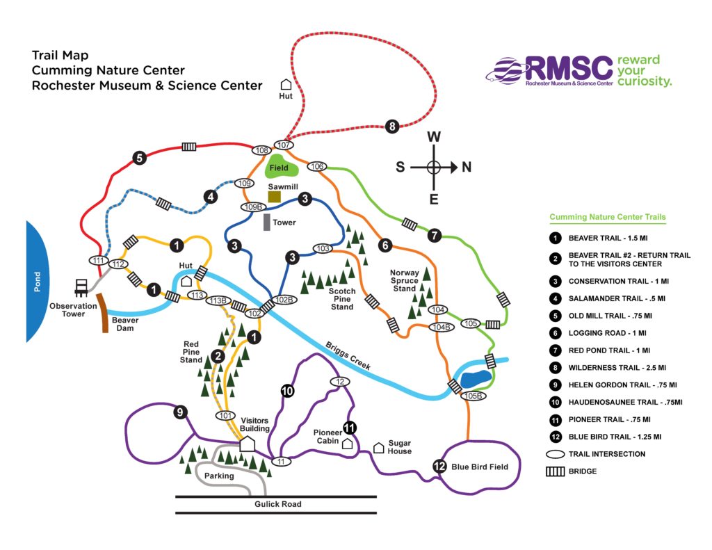
On Feb 16 we will visit Cumming Nature Center in the hills above Naples NY  for hiking/skiing/snowshoeing, depending on conditions.  We’ll be hiking the day after the Nordic Festival ends, so unless there’s a fresh fall of snow in the night, the hiking, skiing and snow shoeing trails will be well groomed and trodden down.

If conditions permit, skis and snowshoes will be available for rental ($15), or bring your own. If you have extras, bring them to share. Whatever your mode of travel, dress warmly with good traction footwear, poles, layers and water. 

Cumming is a branch of Rochester Museum and Science Center. If you are not a member of RMSC, there is a small fee for access to the Center.  Group fees have been paid by SWT, so just identify yourself, at the desk, as part of Springwater Trails Hiking Group.

Our treks will begin at 2 PM.

Social – There’s a choice of socials this time. Those who choose to can go for an English High Tea at Another World B&B; those who prefer our traditional style of social can gather at the Neapolitan Pizzeria in Naples.

A “High Tea” is a sit-down affair with plenty of cakes, pastries, other fancy foods, and of course tea, all served on the host’s finest china. Coffee can be provided for those who really don’t like tea, though people will talk about those who do when they have departed. The cost is $22/person inclusive of everything – probably what we each usually shell out for the social after all the tips and taxes that pad restaurant bills these days. The hosts accept only cash for the High Tea and they won’t complain about us wearing hiking gear.

Another World B&B is at 8404 French Hill Road in Naples.From Cummings, go south on Gulick Road (that’s RIGHT as you exit the Cummings parking lot) and keep going until Gulick Road ends at Ontario County Road 36. Turn right, going up the hill towards Honoeye; then after about a mile or so turn left on French Hill Road. Another World is a mile up this road on the right hand side, and it has a large clear sign announcing it.

The Neapolitan Pizzeria is at 120 N. Main Street in Naples. From Cummings, go south on Gulick Road (that’s RIGHT as you exit the Cummings parking lot) and keep going until Gulick Road ends at Ontario County Road 36. Turn LEFT, going down the hill towards Naples. County Road 36 ends at State Route 21, which also Naples Main Street. Turn left, and the pizzeria is about half a mile along the road on the left hand side.


Directions to the Hike Trail Head

From Rochester and points North: Take 390 South to Routes 5 & 20,   Proceed to Rt15A in Lima. Head South on Rt15A to Route 20A in Hemlock,   Head East on 20A to East lake Road in Honeoye. Proceed South on East Lake Road to County Road 33, (there are signs pointing the way from the junction of East Lake Road and County Road 33). Turn East on County Road 33, then Southwest on Pinewood Hill Road. This becomes Gulick Road.  After 4.7 miles the CNC entrance will be on the right

From Springwater: Go North on Rt 15A to Route 20A in Hemlock,   Head East on Rt 20A to East Lake Road in Honeoye. Proceed South on East Lake Road to County Road 33 (Signs point the way from the junction of East Lake Road and County Road 33). Turn East on County Road 33, then Southeast on Pinewood Hill Road.  This becomes Gulick Road.  After 4.7 miles the CNC entrance will be on the Right.

From Wayland, Naples, and points South: Follow NY 21 East from Wayland,thru N.Cohocton to Naples (11.4miles). Turn Left onto Clark Street (County Hwy36), heading North (Next to Middletown Tavern). Take first Right onto  Gulick Road. Follow Gulick Road for 6.6 miles.   CNC will be on the Left.