Posted on by

Maintenance Hike at Wheaton Hill

This Sunday’s hike will be a maintenance session on Wheaton Hill in Springwater. We won’t be attempting to whack all the grass this year, just the long grass around the access trails.If you want to do more you are welcome to bring a weed whacker and have at it. If you do plan to use a weed whacker, PLEASE BRING EYE PROTECTION! These devices can kick up a lot of dust and small stones. We will be cutting back the roses and other growths, and we’ll be sawing up some trees that have fallen across the trails. If the grass is too long for comfortable walking we will call in the City of Rochester to cut it – they have heavier equipment than we can bring to bear.

Bring gloves to protect your hands, loppers to cut branches and if you have one, a small saw for branches that are too large for the loppers.


The Social:

The plan for a social afterwards is to picnic with our own food parcels and keep a prudent social distance between us. Please bring a folding chair for this – there is nowhere to sit on Wheaton Hill.


Directions:

Wheaton Hill is the first right turn north of the intersection of Rt 15 and Rt 15A in Springwater (0.9 mile north of the intersection).  The trail head is 0.5 miles up Wheaton Hill just before the road turns straight east and heads up the main hill.  More details are on the directions page.

What to bring:

  • Gloves and clippers – hand clippers or long handled loppers for larger branches.
  • A weed whacker if you want to cut grass, with gas mixture and extra string.
  • Small bow saw.
  • Plastic grocery bags in case you find any litter.
  • Water to keep hydrated.
  • Eye protection.
Posted on by

Hi Tor and Naples Creek Hike, 42°37’33.5″N, -77°23’22.7″W

This Sunday promises to be cooler, and we will return to the woods of Naples for hiking along the hills south of the village. Starting at the DEC buildings along Route 245, we will head southwest along Naples Creek, with the groups splitting up near the Ontario Street Bridge.  All hikers meet at 3:45 for a 4 PM start.

Tourists and Naturalists will continue along Naples Creek, skirting the side of Hatch Hill to the parking area at Mark Circle and back, for a total hike of about 3 miles.  This is a fairly flat and easy hike, close to the stream for cooling breezes.

Climbers will take the turn-off for the more challenging Bristol Hills Branch of the Finger Lakes Trail up the hill on the orange blazed trail, cutting off on the blue trail to make a loop past the overlook area and returning to the start by the orange trail. Total distance is about 5.75 miles with roughly 1,100 feet of elevation gain.

Social: Following the hike, we will retire to the community park next to Bob’s and Ruth’s for a picnic with social distance. There are a few picnic tables, but bring a lawn chair to be on the safe side.


DIRECTIONS:

From Springwater/Dansville/Wayland: Take Rt 21N into Naples, turning to the left at the intersection with Rt 53. Turn right after about 1.4 miles down Main St onto Route 245 (across from Bob’s and Ruth’s) and drive .4 miles to the parking area on the right, just over the Naples Creek bridge.

From Honeoye: Take Rt#36 south into Naples, turn left on Main St and drive 1.2 miles and turn right onto Route 245. Parking area is on right, just past Naples Creek bridge.

 From Canandaigua: Take Rt#21S to Woodville.  Turn left at  the intersection with Rt 245, drive approximately .4 miles to the parking area on the right, just over the Naples Creek bridge.


Posted on by

June 7th Paddle and Hike

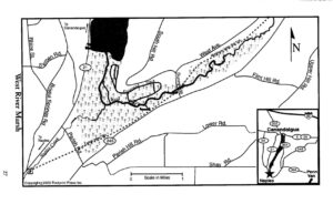
This event will combine a downstream paddle on the West River and a hike on the Middlesex  Valley Rail Trail (aka the Lehigh Valley Trail).  The best time to paddle this waterway is Spring.  Let’s hope we  have timed it right.  According to Native American legend, this is the birthplace of the Seneca Indians.   For images and additional information http://www.ilovethefingerlakes.com/rivers/west.htm

Paddlers  The West River is a lazy stream, so we will be able to do an out- and -back with no problem.  Launching at the Sunnyside Bridge, we will head downstream through a marshland full of waterfowl, turtles, and possibly eagles and osprey.  Distance  will depend on conditions, but likely 4 miles round trip (2 hours).  PLEASE ARRIVE AT LEAST 15 MINUTES EARLY, READY TO LAUNCH AT 4:00.

Hikers  The rail trail is a level path that parallels Rt 245 for 2.6 miles from Sunnyside to Parrish Hill Rd. There will likely be mud, so dress accordingly. The easy terrain lends itself to observing the surprises that nature has to offer.  You might want to bring a camera.  Distance will depend on hikers choice.

Directions  From Route 21 in Naples head northeast on Route 245.  Turn left on Sunnyside Rd and park on the left before the bridge at the brown and yellow DEC sign “West River Fishing Access Site”.  Parking for 4-5 cars.

Social  For those who wish to gather after the event,  the Community Park on Route 245 just east of Naples has a large picnic area with tables and pavilions.  Please bring your own food and drinks.  Social distancing will be observed.  Masks are also advisable.

Posted on by

Honeoye Lake Paddle and Sandy Bottom Park Nature Trail Hike

Looking south down Honeoye Lake from Sandy Bottom Park is one of the most beautiful views in the Finger Lakes.  That is where we will meet on Sunday and split into two groups – one for paddling and one for hiking.  Everyone should plan on meeting in front of the green pavilion by the swimming beach at 4:00 for a general welcome and to sign in.

Paddlers: 

Plan to arrive early enought to have your canoe or kayak unloaded and ready to go prior to meeting at 4:00 at the pavilion.  Unload your boat to the right of the swimming beach and outside of the buoys.  After unloading, take your car back to the main parking area.  You must wear a PFD and should have drinking water, a whistle, and a rope that could be used to tie to your boat.  We will paddle on Honeoye Lake for about two hours – up and back along the west side of the lake.

Hikers:

Park in the main parking area and pick up a brochure/trail map at the small kiosk near the trail head on your way to meeting others at 4:00 at the pavilion.  Hikers may want to split into different groups based on interests, but everyone will basically follow the same loop along the Sandy Bottom Nature Trail up to East Lake Road and back.  The trail winds through a wetland along the Honeoye Lake outlet  (Honeoye Creek) and skirts around an upland agricultural area next to Mill Creek.  It is basically flat, maybe 2 to 3 miles long and has lots to check out along the way – turtles, fish, birds, wild flowers, etc.

Social:

For the social (optional) whoever gets back earliest should try and secure some picinic tables with good views of the lake.  People should bring their own cooler and picnic supper – food, drink, table service, etc. and maybe a folding chair.  No potluck for this social.

There is a nice sand volleyball court, so maybe we will want to try and get a couple of teams together for a game.   As I write this, I don’t know if the swimming beach will be open on Sunday evening or not.  It was closed earlier this week due to blue green algae but when I was there today (Thursday) the water looked good.

Directions: 

Sandy Bottom Park is located at the north end of Honeoye Lake in Ontario County.  At the stop light on Route 20A in the Village of Honeoye, go south on West Lake Road for one-half mile and then turn left onto the Sandy Bottom Park entrance.  In front of you will be the main parking area.

COVID:

All participants will be expected to follow the COVID health and safety guidelines by using social distancing, masks (when needed), hand sanitizers, staying at home if you do not feel well, etc.