Posted on by

Cumming Nature Center

Conditions Update 12-26:  There is about 2″ of compacted snow over an icy base on the trails. A revised hike plan is described below, following the compacted trails that are recommended for use Sunday. Skiing is not recommended. We suggest poles and spikes or YakTrax to ensure good footing. 


Please join us for our post-Christmas hike at Cumming Nature Center, in the hills above Naples.  Conditions are good for a hike on trails with about 2″ of snow over a compacted base.  Cummings is a branch of Rochester Museum and Science Center; if you are not a member of RMSC, there is a $5 access fee to the Center; this provides access to their rest rooms, birding platforms, snacks (free popcorn) and impressive exhibits on local wildlife.  Please wear masks and observe social distance rules throughout the event.
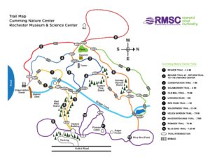
We will meet at 1:50 inside the Visitors’ Center and split into groups to enjoy a nice walk. Trails of various lengths extend north and south from the Visitors’ Center.  Naturalists and Tourists will follow the Beaver Trail through the Cathedral of Pines to the Beaver Pond and return by the Salamander and Conservation Trails for a distance of about 2.5 miles. Climbers will head for the Beaver Pond and Salamander Trail and then make a larger loop on the  Logging Road, and the Conservation Trail, for a total of about 4 miles. 

No Scheduled Social:  Due to the current pandemic surge we are not scheduling social gatherings after our hikes. However the open area at the lower level of the Visitors’ Center will be available for anyone who feels comfortable bringing their own snack and making use of the tables and chairs. The Center closes at 5 PM.

Directions

From Rochester and points North: Take 390 South to Routes 5 & 20,   Proceed to Rt15A in Lima. Head South on Rt15A to Route 20A in Hemlock,   Head East on 20A to East Lake Road in Honeoye. Proceed South on East Lake Road a short distance to County Road 33, (there are signs pointing the way from the junction of East Lake Road and County Road 33). Turn East on County Road 33, then Southeast on Pinewood Hill Road, which becomes becomes Gulick Road.  After 5.6 miles the CNC entrance will be on the right.

From Springwater: Go North on Rt 15A to Route 20A in Hemlock,   Head East on Rt 20A to East Lake Road in Honeoye. Proceed South on East Lake Road to County Road 33 (Signs point the way from the junction of East Lake Road and County Road 33). Turn East on County Road 33, then Southeast on Pinewood Hill Road.  This becomes Gulick Road.  After 5.6 miles the CNC entrance will be on the Right, about 1.5 miles past the Wesley Hill parking lot.  OR, go to Naples and follow the directions below. They are both about 23 mile routes.

From Wayland, Naples, and points South: Follow NY 21 East from Wayland, thru N.Cohocton to Naples (11.4miles). Turn Left onto Clark Street (County Rd. 36), heading North (Next to Middletown Tavern). Take first Right onto  Gulick Road. Follow Gulick Road for 6.6 miles.   CNC will be on the Left.

Posted on by

The Oakland Locks – A 7 Locks Hike in Nunda (42.578516, -77.971108)

Genesee River and Canal 1860s

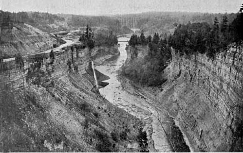
This view of the Genesee River middle falls in Letchworth Park, shows the Genesee Valley Canal clinging to the steep wall of the gorge in the 1860s. Click on the image for more information from Letchworthparkhistory.com.

This week’s hike will follow trail #7 in Letchworth Park.  Trail #7 is the portion of the Genesee Valley Greenway through the park. It is also the section of the Greenway with the most impressive relics of the Genesee Valley Canal. This will be an out-and-back hike with a slightly different return route at the end.

Trail #7 starts at Oakland Rd about a mile outside of Nunda. Here we will walk next to the original locks that allowed boats to climb the hill to the River. The canal operated in this section between 1862 and 1878 and the right of way was sold to the Genesee valley Canal Railroad Company which built a railroad along much of the canal towpath.  As we walk next to the canal lock, the railroad took another route slightly north. In about a half mile, the canal path rejoins the rail path up to Short Track Road. On the return walk we’ll take the Greenway path away from the canal route; we’ll walk as far as Oakland Road and then turn right back to the parking lot.


The Meeting Place:  We’ll all meet at the Oakland Road parking area in Nunda (42.578516,-77.971108) at 1:45pm for a scheduled start at 2:00pm.


The Naturalists will start from the Oakland Rd parking area, following the canal to the junction with the railbed. It is just over a mile to Short Tract Road, where the Naturalists will turn around and hike back to the cars, using the railbed route all of the way, for a two mile hike.

The Tourists will follow the same route to Short Tract Rd. There is a slight jog to the right to follow a detour along Williams Rd. When the road turns left, continue straight into the woods on the Genesee Valley Greenway. The next road is River Rd, also known as Trail #8, where the Tourists will turn left and follow the road south to their cars on NY 436..This hike will be about 3 miles total.

The Climbers will follow the Tourist route to River Rd, where it will continue on the Letchworth Branch of the FLT until 3:00pm when we will turn around and walk back the way we came. On the return walk we’ll keep to the Greenway all the way rather than turn along the canal route. We’ll walk to Oakland Road where we’ll turn right and walk the road back to the cars.


The Social

In recognition of the rising COVID-19 pandemic there won’t be a social on this hike. It will likely be cold and getting dark by the time we get back to the cars, and indoor locations are not advised as yet.

Directions

From Springwater: Follow NY-15 South to Wayland, then turn right on to Route 63 to Dansville. In Dansville, turn left on Ossian Street (Route 436). Follow Route 436 west through Nunda to Oakland Road. Turn right on Oakland Road and the parking area will be on the left. Note that Oakland Road is easy drive past – it’s a small two lane road that goes off to the right 1.2 miles west of the traffic lights in Nunda. The street sign is set back from the 436. There is a trailhead shelter clearly visible on Oakland Road from the junction with Rt. 436.

From Naples: Take Route 21 to Wayland, then continue west on Route 63 to Dansville. In Dansville, turn left on Ossian Street (Route 436). Follow Route 436 west through Nunda to Oakland Road. Turn right on Oakland Road and the parking area will be on the left. Note that Oakland Road is easy drive past – it’s a small two lane road that goes off to the right 1.2 miles west of the traffic lights in Nunda. The street sign is set back from the 436. There is a trailhead shelter clearly visible on Oakland Road from the junction with Rt. 436.

There are two small parking areas at the trailhead. Please park carefully – I don’t think that roadside parking will work because Oakland Road is narrow and curvy.

Posted on by

Harriet Hollister Spencer Park, South Trail

Please join us this warm and sunny fall Sunday to explore a new hiking site not far from Springwater. A few years ago New York State acquired several new parcels of land to the south of Harriet Hollister Spencer Park, linked to the main park by an established snowmobile trail called C4. Last August we hiked the section of the C4 trail closest to the main park, and this Sunday we will explore the rest of the C4 trail, going as far as Dutch Hollow Road and back. The hike will take us across a field with fine views toward Springwater and beyond, and through some little-traveled woods.

Meet at 1:45 PM at the intersection of Canadice Hill Road and Tibbals Road, a.k.a Townline Road (that’s the town line between Canadice and Springwater – also the Ontario-Livingston County Line). Park on the road shoulder. Total distance for Climbers is about 4 miles round trip. Tourists and Naturalists will follow the same route, but turn around after 45 minutes for a total hike of 1.5 hours and about 2.5 miles.

Wear something orange or otherwise conspicuous in case of bow hunters. As always, bring water, good hiking footwear and poles if you typically use them. The trail is gently rolling – no especially steep sections.

Social:  After the hike we will repair to Birdhouse Brewing Company at 8716 Main Street, Honeoye. Sunday afternoon promises to be warm enough for us to be seated on the deck or in the tent. See https://birdhousebrewing.beer/index.php/about/ for their menu of craft beers and food.

Directions:  

From Springwater and Wayland – take Route 15A North from Springwater, turning right on Wheaton Hill Road. Take a left on Canadice Road (County Road 42), forking to the right when County Road 42 divides off from Canadice Lake Road. Make the next right, on Tibbals Road (formerly Town Line Road). The trail head is where Tibbals Road ends at Canadice Hill Road/Wetmore Road.


From Rochester or Canandaigua – go to Honeoye, and follow Route 21A (Main St. Honeoye) west toward Hemlock. About a mile out of Honeoye turn left on County Road 37. Follow County Road 37 until it makes a 90 degrees turn to the right across from the Canadice Methodist Church; at this point go straight onto Canadice Hill Road instead of County Road 37. Continue straight on Canadice Hill Road, taking the left fork at Ross Road, and passing the main entrance to HH Spencer Park. The trail head is 1.7 miles south of the main park entrance, and 8.5 miles from Route 21A. Beyond the trailhead Canadice Hill Road turns into Wetmore Road.

Directions from Hike to Social at Birdhouse Brewing Co.

  •  Take Canadice Hill Rd. going toward Harriet Hollister Parking Lot.  Keep going straight, it will become County Rd. 37.  

  • When you come to Route 20A you will make a right. (at the intersection, St. Mary’s Catholic Church will  be on the Right corner). Take 20A into Honeoye.

  • Birdhouse Brewing will be a brown building on your left, four buildings past the traffic light.

On Sundays they serve Hot Dogs and Hamburgers and are open until 7:00pm.

Posted on by

FLT from Mt. Morris Dam and Wildlife Loop Trail on Dam Property

NOTE: This is the first day of Standard Time.  Please set back you clock or you will be an hour early for the hike!

This Sunday we will hike the Finger Lakes Trail (FLT) starting at the Mt. Morris Dam and Visitors Center Parking Lot, as well as the Wildlife Loop Trail within the Dam property.  We expect to enjoy the remainder of the fall colors and, as we follow the east rim of the Letchworth gorge, the spectacular views of the gorge and Genesee River below.

The Wildlife Loop trail within the dam property is beautiful in its own right, with forest and grassy fields.


Two levels of hiking are planned – “Climbers” and “Tourist/Naturalists” will both hike south on the yellow blazed (FLT) trail along the rim of the gorge, jogging east slightly away from the river across a boardwalk through a small wet area, stop at Hogsback Overlook to view the Hogsback formation of the river gorge, continue on the trail another .2 miles before turning around to head back.  On the way back, we will follow the same yellow blazes but take the alternate orange blazed trail along the rim of the gorge which joins back up with the yellow trail, back to the parking lot.  Total hike is 2.25 miles.

Once back to the parking lot, the “Climbers” who want a longer hike will follow the blue blazed Wildlife Loop Trail which begins just to the right of the Mt. Morris Dam Visitors Center, adding another 1.1 miles to the hike.


The Hike Assembly Point:

The Visitors Center will be closed.  However, there is a bathroom adjacent to the parking lot that may be open on the day of the hike.  All hikers will begin the hike at the Mt. Morris Dam Visitor Center Parking Lot.  The trail access is at the west end of the parking lot (to your left as you face the gorge).  While this trail is in a non-hunting area, it is recommended that you wear brightly colored clothing.


Social:

After the hike, all are welcome to gather at the larger pavilion located adjacent to the parking lot.  Bring your own snack, drink, and chair (due to limited seating and need for social distancing).


Directions:

The Mt Morris Dam Visitor Center is about 45 minutes from Springwater, so please plan ahead. If you have a GPS, try entering Mt Morris Dam as your destination. Or enter Park Rd or Visitor Center Rd, Mt Morris.


From Springwater: Take Rt 15N and then left on Liberty Pole Rd.  Stay on that road all the way to Rt63. There, take a left, and a quick right, onto Rt 258. At Rt 36, take a right and proceed to Mt. Morris. Turn left onto NY-408 South.

From Wayland: you can take I-390 north to exit 7. Turn left at the exit on NY-408 S to Mt. Morris. NY-408 goes left at Main St, then right on Chapel St.

From Hemlock and Honeoye: follow 20A West through Livonia and Lakeville to 390S. Exit at exit 7 NY 408 S to Mt Morris. Stay on 408 through Mt Morris.

From Rochester: Take I-390S to Exit 7 NY 408S.  Stay on Rt 408 through Mt Morris.

From NY 408 in Mt Morris: Go south on 408 for 1.8 miles to Visitor Center Rd. Turn right at the Visitor Center Road and follow the road all the way to the Dam and Visitor Center Parking lot.