Posted on by

Bike Ride at Honeoye Lake, or Sandy Bottom Trail Hike

This Sunday we have a choice of activities, both starting from the northeast corner of Honeoye Lake – a hike on Sandy Bottom Trail and its adjacent creek, or a bike ride along or around Honeoye Lake. Note the later start time of 4 PM for both activities. After the workouts we will adjourn to the Birdhouse Brewing Company at 8716 Main Street, Honeoye for our social/recuperation.

Everyone meets at the Sandy Bottom Trailhead on East Lake Road, about .3 mile from Route 20A/Main Street Honeoye. There are two parking lots side-by-side, each holding about 10 cars.   Hikers will all start out together on the field portion of the trail and then there are options: head down the path to the long winding creek for a creek walk to explore some of the most interesting rocks in the area, and fossils here and there as well. Or, continue walking the field loop into the woods loop and back out to finish the field loop (about 3 miles), then head down to explore the creek. There are  plentiful treasures to see!    Recommended attire – sturdy shoes with decent treads, walking sticks for creek with slippery stones.

For the cyclists there are two options:

-10 mile ride down East Lake Road to the South Boat Launch (5 miles) and return the same way, or

-18 mile loop ride around the lake clockwise, heading down East Lake Road to the South Boat Launch, heading further south to join County Road 36 (West Lake Road), and riding north back to Main Street/NYS Route 20A. Heading a mile east on Main Street and then .3 miles down East Lake Road will bring you back to the start.

Cyclists please bring plenty of water, and helmets are required.

Social:  Please join us afterwards at the BirdHouse Brewing Company, 8716 Main Street, Honeoye, for restorative food and beverages.  See their Sunday Grill specialties at     https://birdhousebrewing.beer/index.php/from-the-kitchen/sunday-grill

Directions:
From the south (Naples, Springwater, etc): Take Rte 21 North to CR 36, make left onto CR 36, make right onto East Lake Road – parking lot is on left just past the County Road 33 intersection.
From the north (Bloomfield, Victor, Rochester, etc): Take CR 40 south to Rte 20A, cross 20A onto East Lake Road, parking lot is on right, 3/10 of a mile from intersection.
From the east (Bristol, Canandaigua, etc): Take Rte 64 south to Rte 20A, make right onto 20A, left onto East Lake Rd
From the west (Hemlock, Livonia, etc): Take Rte 15A to Route 20A, make left onto 20A, right onto East Lake Road

Posted on by

Durand Eastman Park and Arboretum Hike, with Dish-to-Pass Social

Please note: there is a start time change from the earlier published calendar. This will be the last spring hike with a 2PM start time, and the first SWT event of the year to offer a dish-to-pass social option. 

Gene and Georgia Binder are inviting all hikers to join us this Sunday, June 6, at Durand-Eastman Park and arboretum, located on the shore of Lake Ontario.  Most of us find this facility, with its unique botanical collection, to be quite enjoyable.  Carpooling is advisable if you feel comfortable with it.

Hike Plan: We will start at the circle at the south end of Log Cabin Road, a dead end road on the south side of Lakeshore Boulevard, west of Zoo Road. The full group will begin with a leisurely walk to the arboretum, and into it, enjoying the botanical specimens we encounter.  A special feature, at this time, will hopefully be the attractive pink flowers of the mountain laurel, which goes into bloom in June.  These flowers have a unique way of getting bees to transfer pollen and, if there are any open flowers, we will try to demonstrate their sneaky trick.  For those who would prefer a longer and faster hike, the arboretum walk will be followed by a longer trail walk around Durand and Eastman Lakes.

Social: We will all convene back at the circle on Log Cabin Rd., at 4 PM, for our optional after-hike social.  If you’ve been vaccinated, and feel comfortable with it, we will go back to enjoying each other’s kitchen creations, like we used to, so bring something yummy to share with your fellow hikers.  As before the pandemic, place settings will be provided.  If you’re not yet comfortable doing this, just bring your own meal, as you’ve been doing.  If there’s an unoccupied pavilion, we will appropriate it.  However, if they’re all occupied, we’ll just put our chairs out on the lawn so, be sure to pack a folding lawn chair.  We will pack a folding table and, if you have one that you can fit in, we may be able to use it.  We don’t have a portable grill but, if someone has one and wants to bring it, go for it. There will be a small charcoal grill if you want to cook burgers and such.

Directions:  Going north on 390, entering Monroe County, at the first fork, bear right to get on 590.  At the next fork, bear left to stay on 590.  Continue north in the center lane.  When approaching 104, follow signs for sea breeze, avoiding 104 exits.  Approaching the fourth roundabout, note sign for Durand Blvd.  Go ¾ way around to get on Durand Blvd.  Continuing west, you will come to the park, on your left.  Turn left on Log Cabin Rd., the3rd road on your left.  Go to the circle at the end of Log Cabin Rd., and park.  We will meet there.

Posted on by

Spring at Wesley Hill

This Sunday we will be doing a hike at the Wesley Hill Nature Preserve on Gulick Road in the town of South Bristol (Naples mailing address).  We will meet at the parking area on Gulick Road.  Plans for a social gathering following the hike will be announced just prior to the hike, weather permitting and following social distancing guidelines. Please bring lawn chairs if you have them.  Check out a history of the Wesley Hill property visit on the Finger Lakes Land Trust website.

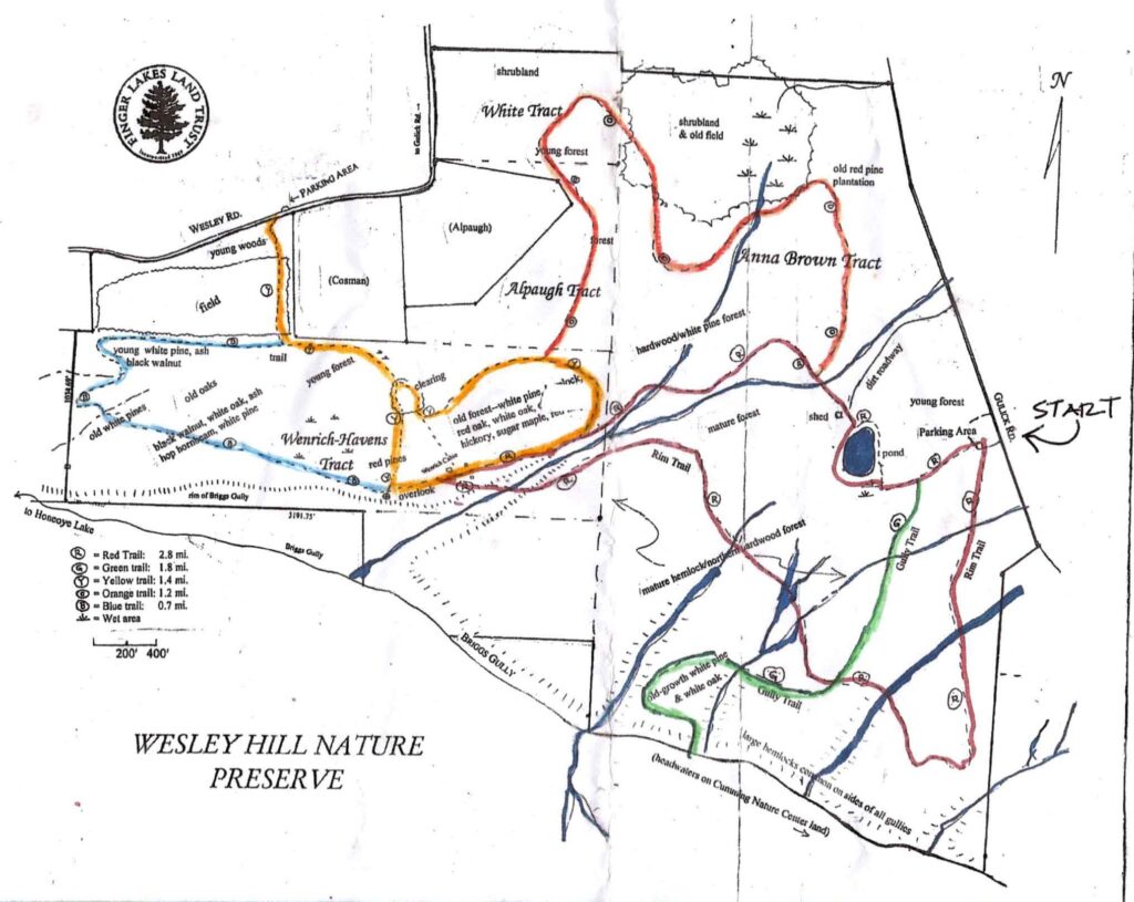
The Climber hike will travel south from the parking lot along the red trail for about 8/10 mile until you arrive at the green trail.  You will then turn left (west) on the green trail and climb down to Briggs Gully.  This is a challenging downhill hike and poles are recommended.  We will rest for about 15 minutes at the gully before climbing back up the green trail back to the Gulick Road parking lot.  The entire distance for this hike is about 2 miles with a significant climb on the way back to the parking lot.

The Naturalist/Tourist hike will head west from the parking lot on the red/green trail, then turn onto the red trail where the trails separate and head toward the pond.  Follow the red trail past the pond, turn left, then right to pick up the orange trail until you arrive at the yellow trail’s split (about 1.39 miles at this point).  Turn left at the split and follow the yellow trail to the red trail and turn left onto the red.  Follow the red trail back to the pond and the parking lot.  This hike is about 2.3 miles in total.  There are gentle climbs, some small stream crossings, and great overlooks of the gully. There may be some slippery, muddy spots so poles are recommended.

Directions: 

From Honeoye: take route 20A east through Honeoye to East Lake Road. Turn right onto East Lake Road. (If coming from Bristol or points east, it’s a left onto East Lake Road).  Take the first left, on CR 33, then the first right onto Pinewood Hill which becomes Gulick Road. Travel about 5 miles to Wesley Hill Parking Area on the right side. Parking lot can fit about 10 vehicles; the rest of us can park on the side of the road (it’s paved).

From Springwater: Head north on Rte. 15A toward Hemlock.  Just before Hemlock, turn right on Rte. 20A.  Follow Rt 20A to Honeoye and then follow the directions above.

From Naples: From the southern end of Naples, head west on Co Rd 36. Follow Co Rd 36 for 1.2 miles to the first right turn on Gulick Rd.  Follow Gulick for about 7 miles.  The parking area is on the left.

Posted on by

FLT Series Hike

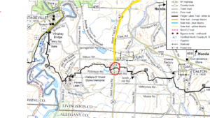
Over the last two years Springwater Trails has held 10 hikes on the Finger Lakes Trail moving west from the Bristol Hills Branch.. We have two more sections, this Sunday and next month, which will bring us to the Genesee River and the Letchworth Branch. Click on the map for a larger view. This Sunday we will hike the section of trail between Dalton NY and Short Tract Rd.

Our best parking seems to be on the shoulder of Short Tract Rd just south of the trail. From Short Tract Rd, we will head east toward Dalton.  The hike will be an in-and-out hike avoiding carpooling for what I hope is the last time. (This is a nudge to get your vaccine!).

The hike starts from Short Tract Rd along the left side of a farmed field.  As of Thursday, there were no crops in this field, but we will be avoid any crops we may come to, staying at the edge of the fields. Throughout the hike, some blazes are old or missing, but there are enough to ensure we will follow the trail. Stay alert!  In a half mile, the trail leaves the field heading left into the woods with nice view of a spring forest. The trail will come out onto Smith Road and turn right onto Smith Hill Road.  Both are dirt roads with little traffic and nice views. The trail turns left onto a private driveway and then another left into the wood. Depending on time, I expect the Naturalists and Tourists to turn around at the next cross road to return to the cars. Climbers may have time to continue across the road, but continuing all the way to Hunt Hollow Rd would mean a 5.5 mile hike, probably more than our 2 hour hike.

As of our pre hike on Thursday, the trail was mostly dry, but with all the rain, your boots will occasionally  get muddy.  Be prepare and you may want  hiking polls to assist your footing crossing the mud.

Social: Bring your own sandwich or salad and beverage and we will meet either at the Nunda Kiwanis Park or at the Oakland Locks Parking area. Please bring a chair if you would like to sit.

Directions:  Please meet on Short Tract Rd about 300 feet uphill from the trail, where the shoulder is plenty wide in front of flat area in front of a small gravel hill.

From Springwater, Naples, Wayland and Dansville: From Springwater head south on NY 15 to Wayland. From Naples head south west on NY 21 to Wayland.  From Wayland, head west on NY 63. In Dansville, at the second light, turn left on Ossian St (NY 36 N). In a half mile, stay straight onto NY 436. Continue for 16.5 miles, through Nunda. The Short Tract intersection is a bit complicated as Short Tract and NY 436 become the same road for 1500 feet.  You will pass Short Tract Rd entering on the right. and then pass Crapsey Rd and CR 70 on the left before your left turn onto Short Tract Rd (CR 20). The trail crosses the road in 2.3 miles. Park on the right hand side, heading south a bit uphill past the trail.

From Mt Morris (and Geneseo and Rochester): Head south on NY 408. In 7.6 miles south of Main St in Mt Morris, turn right onto Short Tract Rd. (If you miss Short Tract, turn right on NY 436 at the light in Nunda). In 5.2 miles, turn right onto NY 436, and in 0.3 miles turn left back onto Short Tract Rd. The trail crosses the road in 2.3 miles. Park on the right hand side, heading south a bit uphill past the trail.