Posted on by

Hi Tor Hike – Naples to Conklin Gully

The Sunday hike on October 10th 2021 will most cover the FLT on Hatch Hill in Naples; the Fall colors should be at the finest for this hike.  The hike will start at the Bob North bridge at the bottom of Ontario Street in Naples. There is a kiosk and a small parking lot there, and all groups will start at the same place. The Naturalists will walk along Matt’s Meander to the Naples Community Park and back, while the Tourist will walk south along Hatch Hill above the town to the south end of Naples. The Climbers will walk north on Hatch Hill to Conklin Gully. Both Tourists and Naturalists will walk back to the parking lot, while climbers will end up at the DEC parking area at the bottom of Conklin Gully and be shuttled back to Naples. Note: the last half mile of this hike is a very steep downhill, but it’s worth it; there are huge drops into the gully to the right of the trail, and wonderful view across the gully and down into it.

There is a DEC display board at the parking lot with a map of all the trails that meet there; all the day’s hiking trails are shown.

The social will take place at Brews and Brats in Cold Springs, Bristol. It’s on Rt. 64 at the junction of rt 64 with county road 12.

NaturalistsNaturalists at Hi Tor
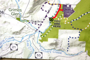
The Naturalists will cross Naples Creek on the Bob North bridge and bear to the left. It is a broad path through woods with the Naples Creek flowing to the left of the path. This trail is called “Matt’s Meander”, and it follows Naples Creek to the Community Park on Route 245. It is about a mile to the end of the trail and back.

Tourists
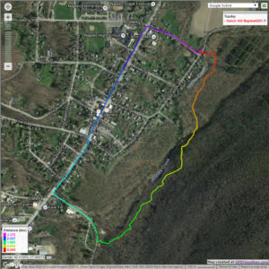
The tourists will cross the bridge and bear to the right. The trail runs south along Hatch Hill above Naples Creek, and goes parallel to both Naples Creek and Naples Main Street, though a lot higher up the hill. This path is not blazed or marked at all but it is well trodden for most of the way; it becomes a little harder to see at the southern end, but once the Turkey Federation parking lot is in sight then it’s not hard to find a way down to it. The trail passes through land that was once grazed and then terraced for vines, but is now returning to woodland. Traces of the shallow terracing for the vineyards can be seen all along the trail, and occasionally an abandoned farm building. The creek can be seen in the valley below the trail all the way along. This trail ends at the south end of Naples, on Mark Circle, where several streams come together to form the Naples Creek. There is water supply facility there, a swimming hole, and an antiques shop. The group will return to the Ontario Street parking lot via Naples Main Street. This walk is 2.1 miles. with just one short modestly steep section.

Climbersnaplesclimbersweb2
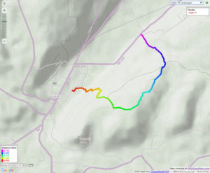
The Climbers will take the Finger Lakes Trail to Conklin Gully through the High Tor Game Management Area. They will cross the bridge and bear left along with the naturalists, and then about half way down Matt’s Meander the FLT branches off to the right. The group will follow the ORANGE blazes on a long uphill section; it’s steep in places with some switchbacks – the trail seems to be going the wrong way at times. There are some ponds at the top of the hill (it’s a mystery – where does that water come from?) with the Howard Beye memorial bench on one of them. It’s important to stay with the orange blazes here – there are several logging roads that make it easy to take the wrong path. Where the trail meets the top of Conklin Gully there is a lookout with a fine view of the Naples Valley and a well organized scout camp, complete with fire pit. The path down the hill from the camp is broad and easy walking. The group will leave the FLT where it branches off to the right over a bridge to the memory of Tom Noteware and follow the BLUE blazes down the hill to the DEC parking lot at the bottom of Parrish Hill.


The Meeting Place

We will meet at the trail head parking lot on Ontario Street, Naples, at 2:00pm on October 10th 2021. The climbers will shuttle some cars to Parrish Hill before starting off.

Getting There

From Springwater and Wayland, come south on Rt. 15 to the traffic light at Rt 21. Turn left on 21 and keep going all the way to Naples. Go through the downtown business area and turn right on Ontario Street, opposite the school. Go to the bottom of the hill and the parking lot is on the left.

From Dansville, follow Rt. 63 to Wayland where the road turns into Rt 21; continue on 21 all the way to Naples. Go through the downtown business area and turn right on Ontario Street, opposite the school. Go to the bottom of the hill and the parking lot is on the left.

From Naples, go to the school on Main Street (Rt. 21). Turn down Ontario Street opposite the school, go to the bottom of the hill and the parking lot is on the left.


The Social

The social will take place at Brews and Brats in Cold Springs, Bristol. It’s on Rt. 64 at the junction of rt 64 with county road 12.

.

Posted on by

Hike at Lucien Morin Park (related paddle is canceled due to weather)

Please note: The schedule paddle in Irondequoit Creek has been canceled due to possible poor weather conditions. If you were hoping to paddle, please come to the hike and social instead. While there may be some showers, temperatures will be good and the hike will proceed as planned.  Be prepared for muddy trails.   

Come to the south end of Irondequoit Bay for a hike in one of Monroe County’s most interesting but least well known parks. Lucien Morin Park abuts the wetlands surrounding Irondequoit Creek, and contains some low but rugged hills and valleys, similar to nearby Abe Lincoln and Durand Eastman Parks. In addition the property was used for target practice by the National Guard back in the mid 20th century, and has some interesting surviving site structures left over from the military use.

Lucien Morin Rifle Range Trail Map

Hikers will meet at 1:45 at the Lucien Morin Park trailhead and parking area  at1135Empire Blvd., just east of the former McGregor’s pub.  We will all start out together on the white trail and dirt road along the wetland (west) side of the park, heading for the gazebo  where the officer used to oversee the shooting operations. From there we will continue on the white trail to the southwest corner of the park, passing several wetland overlook spots. We will split up after hiking about 1 mile (it will seem longer), with the Tourists/Naturalists returning north through the center of the park and the Climbers taking a longer route along the more rugged eastern edge.  Hikes will range from 2.25 to 3 miles. There are some short but moderately steep climbs; bring good boots, water and hiking poles if you use them.  See route maps below:

Lucien Morin Park – 2.2 mile hike along wetland

Lucien Morin Park – 2.8 mile hike through rifle range

Social: Please join us afterward for a dish-to-pass social at Gene and Georgia’s home at 1855 Westfall Road, Brighton, at the southeast corner of Westfall and Fairhill Drive. See directions below.  Bring  your own beverage and a folding chair along with assorted goodies, or donate $5 and help yourself. Bring a card table too if you have one.   We will assemble in the garage if it’s too cool or damp outside.

Directions to Lucien Morin Park:

Take your favorite route toward Rochester, via route 15, 15A, 390, or 490.   When you reach the Outer Loop (390/590), go north on Route 590 toward Irondequoit. About 2 miles after passing through the 490 intersection, take the Empire Boulevard/404 exit. Make a right on Empire Blvd, and go down the hill toward the bay.   Lucian Morin Park trailhead and parking lot will be on your right at #1135, just past the former McGregor’s.

Directions to the Social 185 Westfall:

Head back to the west on Empire Blvd.  You may take 590 south back to the Monroe Avenue (Route 31) exit, then make a left on Monroe and an immediate right on Westfall, proceeding to Fairhill Drive, the sixth left off Westfall. Make a U turn on Fairhill and park on the west side shoulder, next to 1855 Westfall, the house on the corner.

Simpler and more direct route: Head back to the west on Empire Blvd. Before you come to the 590 ramps, turn left on Winton Road. Take Winton Road all the way to Brighton – 4.6 miles. Cross Westfall Road, then take the next left on Fairhill Drive (it’s L shaped). Follow Fairhill around to the left, and park on the right hand shoulder at the last house on the right, 1855 Westfall.


Posted on by

Fall Hike and Picnic

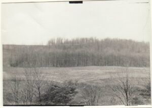
View across valley from main pond 1954.

It is nearly fall and we are taking that as a good reason to have a party.  So join us on Sunday for a hike around Schribner Valley following by a campfire social.  Fall wildflowers are out and the trees are still green so we will be hiking across fields and through the woods. Climbers will enjoy plenty of elevation changes, while Naturalists will take more gradual climbs to enjoy both sides of the valley.

We will meet at 3:00 at the house. The plan is to hike for 2 hours and then meet for an outdoor social around the campfire. We will grill hamburgers and hotdogs or sausage. You are welcome to bring a dish to pass or vegetables to cook. Also bring a chair and your preferred beverage. We will have bocce ball sets and kayak races on the pond for anyone interested.

Climbers and Tourists will head south along the creek. The trail will pass through a natural White Pine forest and next to a planted Norway Spruce forest. We will head down to cross the creek and head up to the top of the hill.  Here, the trail will pass between a mixed planted forest (primarily Red Pine) and a Larch forest that was planted in the 1950’s and harvested in 2017.At the end of the Larches, we will enter the hardwood forest and climb as time and interest allow. Returning back to re-cross the stream, we will explore the oldest Red Pine forest on the property (planted in the 1930’s) to emerge into two fields that are deliberately being kept free of trees. The late season wild flowers are on display. We will continue around the fields and through the woods bordering them. A quick spin around the upper pond will return us to the cars.

Meanwhile the Naturalists will do the same hike in reverse, with more emphasis on flower and tree identification.

Social. A picnic social and campfire will start at 5:00 after the hike. Bring a dish to pass, a beverage and a chair.

We want to make a special invitation to all Springwater Trails alumni to come and join us for the social at 5:00 and catch up with old times.

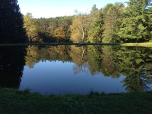
The current view across the pond. The hill and forest in the image above are now hidden by new trees.

Directions: If you use your GPS, please avoid Schribner Rd from Strutt St. The road will shake up your car. Take Giles instead. Our driveway is just below the intersection of Giles Rd and Schribner Rd. Enter the driveway and drive onto the grass to park up against the side of the barn.

From Springwater: Head south on Rt 15A from the light in Springwater.  Take the first left on Marvin Hill Rd. Bear right at the Y onto Strutt St.  Continue straight onto Quanz Rd when Strutt St bears right.  Quanz Rd is a dirt road. Stay on Quanz Road past Fox Rd.  Take the first left turn after Fox Rd onto Giles Rd. (0.7 miles from Strutt St).  Follow Giles Rd to the intersection with Schribner Rd. The driveway is on the right about 10 feet past the intersection with Schribner Rd.

From Wayland: From Rt 15, head east on Rt 21 toward North Cohocton for 3 miles. Turn left on Tabors Corners Rd (Steuben Co Rd 37).  The large sign on Rt 21 says Bowles Corners.After 2 miles, turn left on Schribner Rd (the second left).  The driveway is the 2nd driveway on the left one mile up Schribner Rd and about 10 feet before the intersection with Giles Rd.

From Honeoye: From Rt 20A, head south on Ontario Co Rd 37.  At Canadice, turn right to stay on Co Rd 37. Bear left to stay on County Rd 37.  Turn left at the stop sign at Canadice Lake Road.    Follow Canadice Lake Rd for 2.7 miles to the third stop sign.  Turn left onto Marvin Hill Rd. Bear right at the Y onto Strutt St  Continue straight onto Quanz Rd when Strutt St bears right.  Quanz Rd is a dirt road. Stay on Quanz Road past Fox Rd.  Take the first left turn after Fox Rd onto Giles Rd. (0.7 miles from Strutt St).  Follow Giles Rd to the intersection with Schribner Rd. The driveway is on the right about 10 feet past the intersection with Giles Rd.

From the East Lake Rd in Honeoye or From Naples: Rather than traveling north to reach 20A or Co Rd 37, hikers from east of Honeoye Lake may go south to Ontario Co Rd 36 and follow Co Rd 36 to Naples. Turn right on Rt 21 south.  Turn right to stay on Rt 21  for 4.5 miles to N Cohocton.  Turn right to stay on Rt 21 towards Wayland.  After 3.8 miles turn right on Tabors Corners Rd (Steuben Co Rd 37). After 2 miles, turn left on Schribner Rd (the second left).  The driveway is the 2nd driveway on the left one mile up Schribner Rd and about 10 feet before the intersection with Giles Rd.

From Rochester: You may take your choice by going to Wayland, Springwater or Naples and following the directions from there.  Rt 15A from South Ave in Rochester to Springwater is very easy, as is I-390 South to Wayland (Turn left when you get off I-390 and follow Rt 21 to Wayland).

From Fairport and Pittsford, we go through W. Bloomfield, picking up Co Rd 37 south of Rt 5 & 20  At Canadice, turn right to stay on Co Rd 37. Bear left to stay on County Rd 37.  Turn left at the stop sign at Canadice Lake Road.    Follow Canadice Rd for 2.7 miles to the third stop sign.  Turn left onto Marvin Hill Rd. Bear right at the Y onto Strutt St  Continue straight onto Quanz Rd when Strutt St bears right.  Quanz Rd is a dirt road. Stay on Quanz Road past Fox Rd.  Take the first left turn after Fox Rd onto Giles Rd. ().7 miles from Strutt St).  Follow Giles Rd to the intersection with Schribner Rd. The driveway is on the right about 10 feet past the intersection with Giles Rd.

Posted on by

Canadice Lake Trail, from Purcell Hill Road, with Rob’s Trail option

NOTICE
Four things you should do before this hike
1. Bring hiking poles if you want to hike up Rob’s trail.  It could be very slippery.
2. Wear boots with a good non-slip tread
3. Bring a chair for the social after
4. Check the weather and this website for rain related changes to the plans.
Be safe and stay dry.
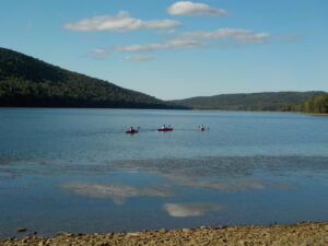
Leading the hike for August 22 will be one of our newer hikers, Jim. We will hike from 4 ~ 6  PM along Canadice Lake and will follow up with a dish-to-pass social next to the lake.
Meet at 3:45 at the northwest corner of Canadice Lake, at the Purcell Hill Road trailhead.  It’s only a short distance up the hill from the intersection of Canadice Lake Road and Purcell Hill Road.  Tourists and Naturalists can walk as far as they want along the lake shore, up to 6.5 miles if you go all the way to the south end, and return. If you have any questions about the kayak paddle or the hike location you can call Jim on (585) 880-0188
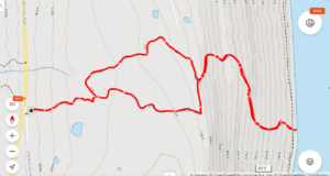
Climbers who would like more of a challenge can  head up Rob’s Trail toward Route 15A.We’ll be working out this hike as we go because of the weather conditions this week – there has been a huge amount of rain, so if the conditions on Rob’s Trail are excessively muddy or slippery we’ll just turn around. This will be a there-and-back hike, and at it’s longest it adds up to almost 6 miles, with half of it easy level walking by the shore of the lake; the questionable part is when we leave the lakeshore and find the steep slopes at the beginning of Rob’s Trail.

Rob's Trail

There are reports of large patches of poison ivy along the trail too, so please take all the usual care and precautions.
The social afterwards will be on the other side of the lake at the Northeast Boat Launch, 1.2 miles south of Purcell Hill Road on Canadice Lake Road.  Bring a lawn chair, a beverage and a folding card table if you have one. Bring your own snack or bring a dish to pass (a $5 donation is a recommended alternative).   Coordinates for the social are  42.727072,-77.564251.

Directions to Hike:

From Springwater: Head north on 15A and make a right on Purcell Hill Road. The trailhead will be on your right in 1.2 miles. 

From Canandaigua, Honeoye and Hemlock: Take Route 20A to the Canadice Lake Road intersection. Go south 3.4 miles to the Purcell Hill intersection. Turn right and go .4 miles. The trailhead will be on your left. 

From Rochester: Take Route 390 south to the 5&20 exit, go east to Lima, then south on Route 15A. After Hemlock, turn left on Route 20A and right on Canadice Lake Road for 3.4 miles. Turn right on Purcell Hill Road and go .4 miles. The trailhead will be on your left. 

Directions to Social:
Head east on Purcell Hill Rd. At the stop sign, turn right on Canadice Lake Rd. The Northeast Boat Launch is 1.2 miles south on the right.