Posted on by

Genesee Valley Greenway Hike from Fowlerville

The Genesee Valley Greenway State Park is a 90-mile open space corridor that follows the route of the Genesee Valley Canal (1840-1878) and the Pennsylvania Railroad Rochester Branch (1882-1963) from the Erie Canalway Trail in Rochester’s Genesee Valley Park to the Village of Cuba in Allegany County. The Greenway will eventually extend to Hinsdale in Cattaraugus County. This Sunday’s hike will start at Fowlersville Rd parking area in the town of  Caledonia and will follow the Greenway north to US-20 and then to NY-5 and finally will follow the Erie-Attica Trail out to a parking area. on Farmers Rd in Avon.

There are three options for this hike.
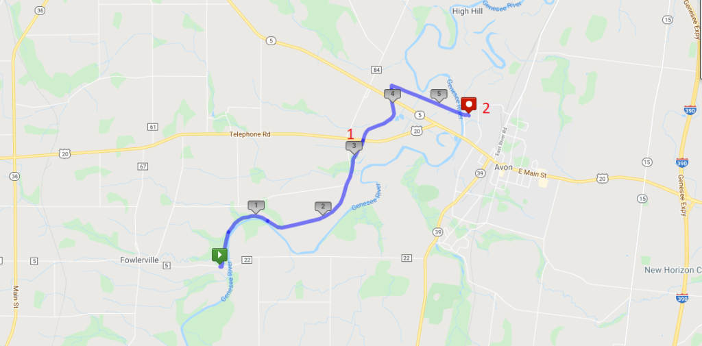
  1. The Tourists will do an out-and-back two hour hike.  This is a good option for any hikers who would prefer to avoid car-pooling during the pandemic. The Greenway starts by following the Genesee River, crossing a couple of streams that cross under the trail through a deep culvert to get to the river. At about the 1.2 mile point, the river wonders through loops to the east, we nice big fields visible between the trail and the river. , The Tourist group should watch the time and turn around  at 3:00 for a two hour out-and-back hike of less than 5 miles. Don’t go past Rt 20 – at that point the out and back will be over 6 miles. For safety sake, slower hikers should always stay in a group of at least 2 hikers and turn around at the same time.
  2. The Naturalists will do a through hike to US Route 20 (Pickup point #1 on the map). There will be a car available at Route 20, to return hikers to their cars.  This option is 3.2 miles and will be limited by the size of the pickup car.
  3. The Climbers will continue on the Greenway past Route 20, and across NY 5. About a tenth of a mile past NY 5, the Climbers will turn right just past two bridge abutments onto the Erie Attica Trail. These abutments carried the Erie-Attica Railroad over the Pennsylvania Railroad. Interested hikers may find the planning study report for the Erie-Attica Trail of interest. This hike is 5.4 miles ending at pickup point 2 and will take slightly more than 2 hours if hikers maintain a 25 minute mile pace. If necessary, hikers can stop at the Route 20 crossing or return to that crossing prior to reaching the Erie Attica turnoff. Hikers who complete the hike to cross the Genesee River at Farmers Rd will have a couple of cars to carry them back to Fowlersville Rd. These cars should plan to stop at Rt 20 to pick up any stragglers.

Following the hike, join us for a social hour at either Tom Wahls in Avon or at the Rising Storm Brewery in South Lima.

NOTE: Carpool drivers should plan to arrive at 1:30 at their pickup point. It is about 10 minutes back to the Fowlerville Rd meetup point.

Directions: To the Fowlerville Rd parking area (the Green start point on the map).

From Springwater: Head west on NY-15 from the light in Springwater. Continue on route 15 through Livonia and Lakeville. At 1.5 miles north of Lakeville, turn left onto Triphammer Rd. In 3 miles at the end of Triphammer Rd, turn right onto NY-39. In 2.5 miles, turn left onto Fowlerville Rd. In 2.9 miles, cross over the Genesee River and the parking area is on the left. After parking, you will cross the road to hike north on the Greenway.

From Naples: Head west from Naples on CR 36 to Honeoye.  Turn left on 20A for 1.5 miles. Turn right onto Big Tree Rd, across 15A  and 15 for 7 miles. At the end of Big Tree Rd, turn left on US 20A into Lakeville. Take a slight right to stay on NY-15. At 1.5 miles north of Lakeville, turn left onto Triphammer Rd. In 3 miles at the end of Triphammer Rd, turn right onto NY-39. In 2.5 miles, turn left onto Fowlerville Rd. In 2.9 miles, cross over the Genesee River and the parking area is on the left. After parking, you will cross the road to hike north on the Greenway.

From Canandaigua: Head west on US 20 through Lima to Avon.  At the traffic circle, take the 2nd exit to stay on Route 20. In 0.3 miles, turn left onto NY-39 (Wadsworth Ave). In 1.7 miles, turn right onto Fowlerville Rd. In 2.9 miles, cross over the Genesee River and the parking area is on the left. After parking, you will cross the road to hike north on the Greenway.

From Geneseo: Head north on NY-39 toward Avon. In 7 miles, turn left onto Fowlerville Rd. In 2.9 miles, cross over the Genesee River and the parking area is on the left. After parking, you will cross the road to hike north on the Greenway.

Directions to the Route 20/Greenway pickup point 1 (Drivers wanting to hike the 3 miles and willing to leave their cars at the parking area on Rt 20).

From Springwater: Follow NY 15 north through Livonia and Lakeville to Route 5 & 20.  Turn left and follow 5&20 around the traffic circle in Avon. In 1.2 miles past the traffic circle, turn left to stay on US-20 as NY-5 continues straight. The Greenway is 1.1 miles ahead with parking on the right.

Directions to the Farmers Rd pickup point 2 (Drivers wanting to hike the full 5.4 miles and willing to leave their cars at the end.)

From Lima: (I assume you can find Lima!) Follow 5 & 20 west for 8 miles, around the traffic circle in Avon. Just before the Genesee River, turn right into Farmers Rd.  Follow the road for half a mile, passing through the underpass under the trail. The underpass may have a pool of water under it. The parking area is on the north side of the underpass.

Directions From Farmers Rd to Fowlerville Rd: Turn right on 5&20. In 0.4 miles, turn left to stay on US-20. (Stop at the Greenway to pick up any drivers who have parked at the Rt 20 parking area.) In 3.5 miles, turn left onto Casey Rd.  At the end of Casey Rd, turn left onto Fowlerville Rd. The parking lot is on the right in 1 mile.

 

Posted on by

Hike at Stony Brook State Park, Dansville

LOCATION:  Enter the park through the North Entrance off of NY-36 and drive past the admission gate (this is considered “off-season” so no fees will be charged) to the parking area.  We will start our hikes from the Clara Barton Shelter which is to the left of the parking area.  Bathrooms near the shelter will be open.

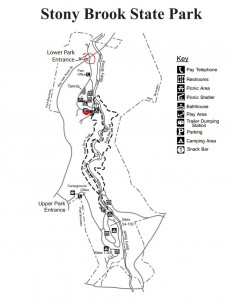
HIKE DESCRIPTION:  Stony Brook is one of the Finger Lakes State Parks which was the site of a Civil Conservation Corps camp during the 1930’s.  Many of the trails and facilities at the park are thanks to the work that they did. We will hike on three trails that cover the length of the park – the Gorge Trail, West Rim Trail and East Rim Trail.  The Gorge Trail runs along Stony Brook at creek level while the other two trails wind along the top of the gorge.  Hikers will appreciate the work done this past summer to replace stone steps and wooden stairs where needed.  We will split into three groups with each group walking at their own pace.  All three trails have many steps and are most likely going to be wet and slippery so poles and traction devices or good treaded hiking boots are recommended.

Climbers will hike the West Rim Trail and the East Rim Trail. They will cross over the playground area to the West Rim Trail trailhead and begin climbing about 400′ in elevation to the top of the gorge. The trail then goes along the rim to the upper park where hikers will go over the stone bridge and return back to the lower park along the East Rim Trail.

Tourists will hike the Gorge Trail and the East Rim Trail.  They will go past the swimming area to the Gorge Trail trailhead and continue up past three waterfalls to the upper park where they will cross over the stone bridge and return back to the lower park on the East Rim Trail.

Naturalists will hike the Gorge Trail out and back.  They will go past the swimming area to the Gorge Trail trailhead and continue as far as they want then return by the same route.

RECOMMENDATIONS: The weatherman is calling for cooler weather and a possibility of showers on Sunday so be prepared.

SOCIAL:  An after hike social will be at the Clara Barton Shelter. Cider and donuts will be provided.  If there is enough interest we could go in on a pizza and have it delivered to the park  – people will be asked about this prior to beginning the hikes

DIRECTIONS:  From the Village of Dansville take NY-36 South.  The North Entrance to Stony Brook State Park is several miles south of the village on the left.

Leave a Reply

Posted on by

Auburn Trail Hike or Ride from Mertensia Park

About the Auburn Rail Trail:   This crushed-stone trail follows the corridor of a New York Central line from Farmington to Pittsford. There remains one gap in Victor, but work is under way to close it.  The trail is currently maintained by the Victor Hiking Trails organization in close cooperation with the town of Victor.

Our hike and bike ride for Sunday, 10/17/21 will begin at 2:00 pm from Mertensia Park in the town of Farmington, where all hikers and bikers will meet (and there is plenty of parking at the park).

People will have the option to hike or bike along the Auburn Rail Trail going westbound from the park. We will likely see peak fall colors. The trail surface is crushed, granular stone and mostly dry. There are many fallen apples, chestnuts, sticks, and leaves on the trail, so poles are recommended. Otherwise, this is an easy, mostly flat trail.

Hikers:   All hikers will start together from the parking lot at the park, walking westbound. Naturalists and Tourists (or those wanting a shorter hike) will walk out and back, turning around where they wish, back to the park – joining at least one fellow hiker.

“Climbers” (or those wanting a longer hike) will hike out for about 60 minutes, then turn around and return to the park.

Bikers:  Bikers will also ride westbound out and back. NOTE – AT APPROX. ¾ MI. INTO THE RIDE, BIKERS WILL TURN RIGHT AT EAST VICTOR RD. FOR ABOUT 0.2 MILE, TURN LEFT ONTO BREAK OF DAY ROAD FOR 0.1 MILE, THEN RE-ENTER THE AUBURN RAIL TRAIL ON THE SOUTH SIDE OF THE ROAD AND CONTINUE ON THE RAIL TRAIL. (HIKERS WILL NOT TURN RIGHT ONTO EAST VICTOR RD. THEY WILL CONTINUE STRAIGHT THROUGH THE CROSSWALK ON EAST VICTOR RD. AND ENTER A LOCAL TRAIL, WHICH ENTERS VICTOR HILLS EAST CLUB PROPERTY AND JOINS UP AGAIN WITH THE AUBURN RAIL TRAIL.)

In Victor the Auburn trail goes past the site of a circa 1840 railroad depot of the Auburn and Rochester Railroad, which lends its name to the trail. The depot is privately owned, as is an adjacent boxcar. NOTE – AT THIS LOCATION, BIKERS WILL CONTINUE ACROSS THE ROAD ON A TRAIL WHICH WILL JOIN BACK UP WITH THE AUBURN TRAIL. HIKERS ALSO, WILL CROSS THE ROAD IF THEY GET THAT FAR (WHICH IS UNLIKELY). Bikers will ride from Mertensia Pk. to RR marker 90 (near turn off to Powder Mills Park), take a short break and then head back to Mertensia Pk. (approx. 16 miles total).

Social Gathering:  After the hike/bike ride we will gather at the Irish Mafia Brewing Company, located at the intersection of Routes 20 & 64 (Toomey’s Corners), 2971 Whalen Rd., Bloomfield, NY 14469.  For more information about the restaurant and brewery visit irishmafiabrewing.com 

Directions and Parking at Mertensia Park:   Mertensia Park is located at 1390 Mertensia Rd., Farmington, NY 14425

From Springwater: Head north on NY 15A. Take a slight right onto Old Bald Hill Rd S, then a quick second right onto Johnson Hill Rd. At the end of Johnson Hill Rd, turn left onto CR 37 and continue on CR 37 through Canadice. Turn right onto US 20A. In 7.9 miles, turn left to stay on US 20A and NY 64. At the intersection with Rt 5&20, continue straight onto Whalen Rd, then turn right on North Bloomfield Rd. Continue to New Michigan Rd. (turn left). Drive 3.5 mi. to CR 41, turn left and drive 0.1 mi. to Mertensia Rd. The park entrance will be about 0.2 mi. on your left.

From Naples:   Head northeast on State Rte. 21N. Continue to follow State Rte. 21N to NY-64N in South Bristol to Toomey’s Corners (Rte. 20/64). Continue straight onto Whalen Rd. then turn right on North Bloomfield Rd. Continue to New Michigan Rd. (turn left). Drive 3.5 mi. to CR 41, turn left and drive 0.1 mi. to Mertensia Rd. The park entrance will be about 0.2 mi. on your left.

From Honeoye:  Drive on Rte. 20A east to 20A East/64N and then follow directions above (from Naples).

Posted on by

Halloween Hike or Bike Ride – Canadice Lake

This Sunday we will bicycle and hike along the west side of Canadice Lake. We will meet at the north end of Canadice off of Purcell Hill Rd.  Both hikers will head south on a pleasant and easy maintenance road that seems to be a favorite route for many local walkers and skiers (when there is snow). Climbers, Tourists and Naturalists will all hike the same route, each group going at its own speed and distance.

Please arrive a few minutes early so we can organize and start hiking at 2:00PM.

Since it’s Halloween, everyone is invited to cycle and hike in costume. Curses on politicians of any stripe are forbidden on state land, but well behaved dogs are welcome.

The Hikers

This hike will be a slow walk up and down the Canadice shoreline. We’ll walk south for an hour and then return to the starting place. Based on our hiking speed, some hikers will have time to head up Rob’s Trail for a view of the lake from above. If the lake level is low we will investigate a route down to the water for a walk back on the rocks of the shoreline.

The Bicyclists

The bicyclists will cycle south down the west side of Canadice lake to the end of the lake, and then return the same way. Since this is a short distance for a bike ride, we’ll explore the roads and trails at the south end of the lake before returning to the starting place.

The Social

The social will be at the Birdhouse Brewery in Honoeye.


Directions (click here for a more detailed guide):

We will meet at the northwest parking area for Canadice Lake on Purcell Hill Road west of Canadice Lake Road. Please note that this is not a boat launch.

From Rochester and the I390 Exit 11 Park and Ride: From Rochester, take I390 south to Exit 11.  Turn left (south) on Rt 15.  The park and ride is on the right side.  From the park and ride, turn right onto Rt 15 and then an immediate left onto Rt 251 toward Rush.  After 1.3 miles, bear right onto 15A.  Follow 15A through Rush, Lima and Hemlock for 18.5 miles.  Turn left on Purcell Hill Road for 1.2 miles.  At the bottom of the hill, the parking area is on the right before you cross the Canadice outlet.

From Springwater: Take 15A north from the Rt15 intersection for 7.6 miles.  Turn right on Purcell Hill Road for 1.2 miles.  At the bottom of the hill, the parking area is on the right before you cross the Canadice outlet.

From Honeoye:  From Rt 20A, turn south on CR 37.  After 3.7 miles turn right at the white church in Canadice.  Stay straight onto Burch Hill Rd when CR37 bears to the left.  Follow Burch Hill Rd down to Canadice Lake Rd.  Turn right (north) on Canadice Rd for 0.7 miles, then left on Purcell Hill.  The parking area is on the left in 0.2 miles.