Posted on by

Genesee Valley Greenway – North from Avon

The Genesee Valley Greenway State Park is a 90-mile open space corridor that follows the route of the Genesee Valley Canal (1840-1878) and the Pennsylvania Railroad Rochester Branch (1882-1963) from the Erie Canalway Trail in Rochester’s Genesee Valley Park to the Village of Cuba in Allegany County. The Greenway will eventually extend to Hinsdale in Cattaraugus County. This Sunday’s hike will start at the Erie-Attica Trail parking area on Farmers Rd in Avon, as parking is limited at the road crossings of the Greenway itself.
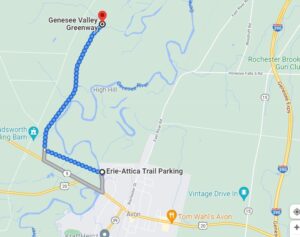
All groups will do a 2 hour out-and-back hike or ski, depending on conditions.  The trail is flat for almost the entire distance, with minor hills at the trail intersection and a farm road crossing.  The Greenway is often popular with snowmobilers, which can create a rough skiing surface.

All groups will head west on the Erie-Attica Trail across the Genesee river bridge and continue for 1.1 miles to the Greenway intersection.  Several sets of bridge abutments are visible along this stretch, with the largest marking the bridge which carried the Erie-Attica Railroad over the Pennsylvania Railroad. Interested hikers may find the planning study report for the Erie-Attica Trail of interest.

All groups will turn right (north) on the Greenway and continue until the turn-around time.  The views in this area are at risk from the proposed Horseshoe Solar Array which will likely start construction soon in Caledonia and Rush.

Following the hike, join us for a social hour at The American Hotel in Lima, famous for their soup selection.

Directions to the Farmers Rd Parking Area

From Springwater: Head north on NY-15A for 18.8 miles to Lima.  Turn left at the light onto 5 & 20 and travel 7.6 miles west (through the traffic circle in Avon) to Farmers Road on the right just before the Genesee River Bridge.  Follow Farmers Rd for half a mile, passing through the underpass under the trail. The underpass may have a pool of water under it. The parking area is on the north side of the underpass.

From Naples: Head west from Naples on CR 36 for 14 miles to Route 20A in Honeoye.  Turn left and travel 1.5 miles. Turn right onto Big Tree Rd, travel 3.5 miles to Route 15A.  Turn right and continue to Lima, following Springwater directions to trail parking.

From all points north: Take Route 390 to Exit 10 (Avon).  Turn left onto Route 20 west and continue through traffic circle in Avon and to Farmers Road (3.5 miles)

The American Hotel is on the corner of Route 20 and Route 15A in Lima. Turn left at the exit from Farmers Rd and continue for 7.6 miles to the light in Lima.


Posted on by

Crescent and Seneca Trails

Our hike this Sunday will be on the southern portion of the Crescent Trail in Perinton, NY. The Crescent Trail is a system of footpaths within the Town of Perinton suitable for uses such as hiking, cross-country running, snowshoeing, nature study, and photography.  Approximately thirty-five miles of footpaths provide public access to wooded hills, Town parklands, scenic overlooks, the margins of wetlands, and other preserved open spaces. Our hike will start on the Seneca Trail, one of the trails in the Victor Hiking System. We will hike north on the Seneca Trail to connect the trails systems of the two towns, and then along the main Crescent Trail,

From the parking lot, we will head NW on the Seneca trail to Lasalle Parkway that runs parallel to Highway 96. After a quarter mile on Lasalle we join the Crescent Trail system on a gray trail to join the orange trail that links Route 250 to Turk Hill Road. From the 50 Square Drive to the Orange trail is a 35 minutes walk. Then:

  • Naturalists will go west on the orange trail for as long as they want and return on the same route to 50 Square Drive and to the Distillery if they wish.
  • Hikers will go east on the orange trail for as long as they want and return on the same route to 50 Square Drive and to the Distillery if they wish.

The trails are steep in parts, run along creek beds and are very pretty. Lots of ups and downs. Poles are recommended.

Following the hike, the Distillery across the parking lot is available for a social. Please bring a mask for entering the restaurant.

Directions:

From Springwater, Wayland and Honeoye:  Head north on NY 15A. Take the first right outside town onto Wheaton Hill Rd. Turn left onto Canadice Rd CR42 (the first left). Stay on CR42 as it turns right up the hill toward Canadice. The road becomes CR 37 in Ontario County.  Stay on CR37 with a left at Canadice and all the way to West Bloomfield. Continue straight onto NY 65, and then outside of W Bloomfield, stay straight onto CR 35 as NY 65 curves left. This road becomes CR 66 in Monroe County.  Turn right onto NY 251, Rush Mendon Rd. Stay on NY 251 for 3.4 miles. Turn left onto Phillips Rd, as 251 curves to the right. At the light turn right onto  Main St Fishers, then left onto NY-96. In 1.7 miles (probably the 4th light) turn right onto Turk Hill Rd and then turn left into the plaza at the first light.  We will meet in the parking lot on the right in front of the office building.

From Naples: Head north on NY 21. Continue straight onto NY 64 in South Bristol when 21 turns to the right. In 13 miles, turn left at the light onto Rt 5 & 20.  In 1.2 miles, turn right onto NY 444 toward Victor. In Victor, turn left onto NY 96 for 4.2 miles. Turn right onto Turk Hill Rd, and then turn left into the plaza at the first light.  We will meet in the parking lot on the right in front of the office building.

From the Thruway: Use Exit 45 for I-490 W. Take the first exit (Exit 29). At the light turn right onto NY 96. Turn right onto Turk Hill Rd, and then turn left into the plaza at the first light.  We will meet in the parking lot on the right in front of the office building.

From Rochester: Use I-490 E to Exit 28. Turn left onto NY-96. In 1.3 miles, turn left onto Turk Hill Rd, and then turn left into the plaza at the first light.  We will meet in the parking lot on the right in front of the office building.

From Fairport and Penfield: Take NY 250 south. Turn left onto NY 96. In 0.6 miles, turn left onto Turk Hill Rd, and then turn left into the plaza at the first light.  We will meet in the parking lot on the right in front of the office building.

Posted on by

A Boxing Day Bash – French Hill in Naples – Sunday 26th December @ 2:00pm EDT – (42.611704, -77.457603)

Come fight off of your Christmas day hangover with a hash walk at Another World Bed and Breakfast on Sunday December 26th at 2 pm. We will wander around the property with three goals in mind:

  1. Don’t get lost
  2. Have food and drink afterward
  3. Pick on John L at every opportunity.

For those who may not be familiar with hashing, a hash follows a marked route that contains checkpoints and false trails to keep you thinking and get you frustrated. You will be driven on by the fact that a cold beer awaits when you finish. The original idea of the hash was to promote physical fitness, get rid of weekend hangovers, acquire a thirst that will be slated, and persuade all-comers that they are not as old as they feel.


Directions

From Naples: Take Main Street to Clark Street (Middletown Tavern is on the corner) and take Clark out of the town. After about 2 miles turn left on French Hill Road. After about 1 mile, Another World will be on the right at 8404 French Hill Road. Park in the driveway

From everywhere else in the universe: Take your favorite route to Naples and follow the direction above!!!!!!!


The Social

Soup, Dessert, and refreshments will be served to all survivors.

Posted on by

Harriet Hollister Spencer Park, Canadice

Please join us this  Sunday to explore a  hiking site not far from Springwater. A few years ago New York State acquired several new parcels of land to the south of Harriet Hollister Spencer Park, linked to the main park by an established snowmobile trail called C4.In the past, we’ve hiked the section of the C4 trail closest to the main park, and this Sunday The Climbers will start from the main parking lot and hike out following Ruthies trail  to C4 off Deremus trail  going as far as the intersection of Canadice Hill Road and Tibbals Road, a.k.a Townline Road (that’s the town line between Canadice and Springwater – also the Ontario-Livingston County Line). Climbers can return to the main parking area by returning back on C4 or following the Canadice Hill Road back. Total distance for Climbers is about 4 miles round trip. Tourists and Naturalists will follow the same route  until the C4 turnoff but stay in the main park,  for a total hike of 1.5 hours and about 2.5 miles.

Wear proper clothing according to prevailing weather conditions . As always, bring water, good hiking footwear and poles if you typically use them. The trail is gently rolling – no especially steep sections.

Social:  After the hike we will repair to Birdhouse Brewing Company at 8716 Main Street, Honeoye,  for their menu of craft beers and food.

Directions:  

From Springwater and Wayland – take Route 15A North from Springwater, turning right on Wheaton Hill Road. Take a left on Canadice Road (County Road 42), forking to the right when County Road 42 divides off from Canadice Lake Road. Make the next right, on Tibbals Road (formerly Town Line Road). The trail head is where Tibbals Road ends at Canadice Hill Road/Wetmore Road.


From Rochester or Canandaigua – go to Honeoye, and follow Route 21A (Main St. Honeoye) west toward Hemlock. About a mile out of Honeoye turn left on County Road 37. Follow County Road 37 until it makes a 90 degrees turn to the right across from the Canadice Methodist Church; at this point go straight onto Canadice Hill Road instead of County Road 37. Continue straight on Canadice Hill Road, taking the left fork at Ross Road, and passing the main entrance to HH Spencer Park. The trail head is 1.7 miles south of the main park entrance, and 8.5 miles from Route 21A. Beyond the trailhead Canadice Hill Road turns into Wetmore Road.

Directions from Hike to Social at Birdhouse Brewing Co.

  •  Take Canadice Hill Rd. going toward Harriet Hollister Parking Lot.  Keep going straight, it will become County Rd. 37.

  • When you come to Route 20A you will make a right. (at the intersection, St. Mary’s Catholic Church will  be on the Right corner). Take 20A into Honeoye.

  • Birdhouse Brewing will be a brown building on your left, four buildings past the traffic light.

On Sundays they serve Hot Dogs and Hamburgers and are open until 7:00pm.