Category Archives: Sunday hikes
Rochester Folk Art Guild Lecture on the Lawn and Hike
East Hill Farm, home of the Rochester Folk Art Guild, is a community of craftspeople producing fine quality handmade products in wood, pottery, fabrics, paper, toys, books and more. On Sunday September 11th the Guild is graciously letting us pair a hike across their 350 acre hilltop farm with a presentation that is part of their summer Lecture on the Lawn Series. We will have an opportunity to visit their Gallery Shop in between the lecture and the hike.
LECTURE ON THE LAWN –
The lecture begins at 2PM and will be given by Dr. Bruce Gilman, Professor Emeritus of Environmental Conservation at Finger Lakes Community College. The title of his presentation is: The Local Landscape Then and Now: Glacial History, Early Forests and Current Ecological Communities. Briefly, the lecture will last approximately one hour, will be held rain or shine, and is free to the public but donations are appreciated. Bring a lawn chair. Details can be found at: https://www.folkartguild.org/lol/
HIKES –
Hikers will meet around 3:30PM in front of the East Hill Gallery (the first building as you come up the driveway). Climbers and Tourists will head south through the Guild’s farm and neighboring properties, past a pond and sauna, through a spruce grove, and looping through woods and mowed fields to a view looking east across Italy Valley. We will return through the woods and pass an eclectic array of residential building, workplaces and gathering places, designed and built by community members over their 50 years of occupancy at the East Hill Farm. Total distance is about 3.5 miles. Naturalists will follow a shorter route and go at a slower place taking time to observe late summer wildflowers. Trails are gently sloped.
SOCIAL –
Following the hikes, we will gather for pot luck on the lawn near the farmhouse or in the dining room if it is raining. People should bring a dish to pass (or make a donation to the social fund) and something to drink.
DIRECTIONS –
from Springwater/Naples: Take Route 15 south to Wayland and Route 21 east/north to Naples. Turn right on Route 245 opposite Bob and Ruth’s Restaurant, at the north end of the village. Follow Route 245 to Middlesex, about 8.75 miles. Turn right on Route 364 and go up the hill one mile. Turn right on Upper Hill Road and go 1.5 miles. East Hill Farm will be on your left at #1445. Park on the road shoulder and walk in the driveway.
from Rochester and points north: Head to Route 5&20 vial Bloomfield or Canandaigua. At the east edge of the City of Canandaigua (first light after Wegman’s/Post Office), turn south on Route NYS Route 364 (a,k.a. East Lake Road). Follow Route 364 south 12.5 miles to Middlesex, where 364 turns to the east and you will make a left onto Route 245 and then an immediate right to continue on 364. Go up the hill one mile. Turn right on Upper Hill Road and go 1.5 miles. East Hill Farm will be on your left #1445. Park onthe road shoulder and walk in the driveway.
Sonyea State Forest Hike
NOTE: As of Sunday morning, it looks like light rain much of this afternoon. The hike is still on, but the social will be at a restaurant. See you at 4:00.
This Sunday, we’re returning to Sonyea State Forest in Livingston County, to hike along the Keshequa Creek. Since the last time we hiked in this forest, the DEC has made some (minor) improvements, including designating 5 primitive camp sites. On our hike, we may find a campsite you will want to return to for a respite from the daily grind.
 We will meet at 4 PM at the gate that marks the head of the Keshequa Creek Falls Trail about 2.7 miles from the beginning of Union Corners Rd. See directions below. All hikers will walk around the gate to a well groomed trail the heads down a steep hill to the creek. Be careful walking down, and on the way back you will want to take your time climbing this hill. But the hill is not long and most of the rest of the trail is along the old Genesee Valley Canal and railroad bed. Our hike will take us to the western side of the forest, where we will encounter the gorge along Keshequa Creek. Within the gorge, we will see remains of the Genesee Canal and a major branch of the Pennsylvania Railroad, as well as rapids and falls along the creek.
The Naturalists will hike about a mile along the trail to a beautiful wide point in the creek where we can explore the falls and the intricate cracks in the rocks. After exploring that location, Katherine will lead the Naturalists back to the car the way we came.
The climbers will continue on the trail past the falls to the end of the trail, and then will return to the cars by way of the field to the entrance of the State Forest, and will walk on Union Corners Rd. If conditions or time require, we may adjust the route and return the way we came. Mark will lead the climbers..
After the hike, we will enjoy the August weather with a picnic in the woods. Bring a dish to pass, or make a donation. We will select a clear area so, bring folding chairs, and a table, if you have one. There are no washroom facilities, not even portable ones, but lots of trees If the day should turn out to be a rainy one, we will return to the Sunrise, in Dansville.
Directions: Please Note: Directions on Google Maps from Springwater takes you on NY 36 North to Craig Rd up through the Groveland Correctional Facility. This road is closed to cars, although walkers and bikers are allowed to use it as part of the Genesee Valley Greenway trail.. This is not a good way to get to our hike. Please follow the directions below.
From exit 6 on 390, turn south on NY 36. Then, take the first right onto CR 72, aka Presbyterian Rd. Follow it for 3.7 miles, bearing right at the intersection with CR 11, to Union Corners Rd. Turn right here and keep going for 2.7 miles,, till you see the gate. Union Corners Rd is unpaved, with potholes, making for slow going so, consider this in planning your travel time. Turn around at the gate and park on either side of the road.
From Springwater: Take NY 15 west from the flashing light. At the top of the hill (1.5 mi), turn left onto Liberty Pole Rd.(CR 38). Continue for 8.1 miles as the road number changes from CR 38 to CR 1A to CR 1. Turn left onto NY 63 S. In just 0.3 miles take the first right onto N 258. In 1.9 miles, continue straight across NY 36 and onto CR 72 (Presbyterian Rd). Follow the directions above to the state forest.
From Naples. Follow NY 21 S to Wayland. At the first light, turn left to stay on NY 21. In 1.8 miles south of Wayland, turn right on I-390 N. In 16 miles, take Exit 6. Turn right onto NY 36. Follow the directions above.
Camp Cutler – Cleveland Hill Hike
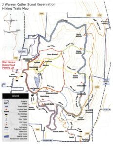
Sunday September18th we will be hiking the trails around Camp Cutler, the scout camp between Gulick Road and Hunt Hollow Road (County Road 33) in Naples. Here’s the trail map: 
The hike – We will meet at 2:00pm at the shelter/pavilion at the edge of the large parking lot at 7131 Gulick Road. We’ll divide 2 groups, climbers, and tourists/naturalists. All groups will start off together, walking north from the parking lot. The trails are well marked with colored blazes and are easy to follow, but always look for the next blaze! Both groups will start out together following the camp roads.
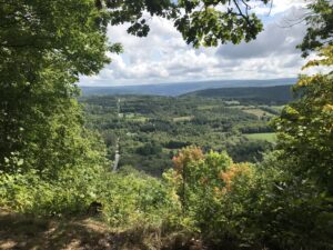
At the first fork, stay to the left at the start of the red trail. A short distance up the hill, you will see a sign for the Nature Trail. Turn left off the road onto the blazed red trail. The Naturalists/tourists will follow the Red Trail which will loop around the pond for a total of 2.54-3 miles. The Climbers will complete a 5-mile loop around the perimeter of the camp. This hike does not disappoint, with two beautiful lookouts with spectacular views. We will avoid the areas of recent logging activity. Bring water and a snack for this long hike. There is a place to sit at each lookout. Poles are suggested; if it is wet, it may be slippery in spots.
The Social – After the hike, we will meet at the pavilion at the end of the parking lot for a social. Please bring a dish to pass and something to drink.
Directions: From Honeoye: take route 20A east through Honeoye to East Lake Road (CR 33). Turn right onto East Lake Road. (If coming from Bristol or points east, it’s a left onto East Lake Road). Take the first left, staying on CR 33, then the first right onto Pinewood Hill which becomes Gulick Road. Travel about 7 miles to Camp Cutler at 7131 on the left side. There is a big sign and a large parking area.
From Springwater: Head north on Rte. 15A toward Hemlock. Just before Hemlock, turn right on Rte.20A. Follow Rt 20A to Honeoye and then follow the directions above.
From Naples: From the southern end of Naples, head west on Co Rd 36. Follow Co Rd 36 for 1.2 to the first right turn on Gulick Rd. Follow Gulick for about 5 miles, the camp will be on the right. There will be a big sign and a large parking area.

