Posted on by

Stid Hill Hike

The Stid Hill Multiple Use Area is a 847 acre tract of land situated in the townships of Bristol and South Bristol in Ontario County. It is bHiking trails at Stid Hill WMA in Bristol, NYounded by Route 64 on the west and Dugway Road on the north. Ganargua Creek, better known as Mud Creek, flows along Route 64. At one time, Stid Hill was productive sheep and cattle grazing land. Today the grazing has been eliminated. The mixture of steep hills, ravines, gullies, gorges, woods, and open areas create scenic vistas and also provide varied wildlife habitats.
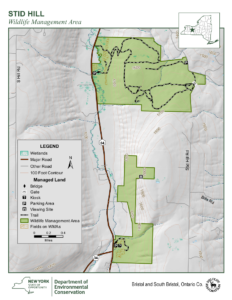
Sunday May 28, 2023 we will all meet at the Stid Hill MUA parking area on Rt. 64 at 1:45pm.  At this meeting point we will divide into groups.  Climbers will carpool to Dugway Rd. and hike back down to Rt. 64.  The Tourists and Naturalists will follow the trails from this access point on Rt. 64.  The ground is uneven so you may want to bring poles.  There may also be very wet and muddy spots along the trail so waterproof hiking shoes or boots would be recommended.   

The Meeting Place

We will all meet at the Stid Hill MUA parking area on Rt. 64 at 1:45pm. This parking area is for the northern portion of the Stid Hill area.  It is after Bristol Mountain ski area if coming from Naples, and after Dugway Rd if coming from 5&20 or 20A.

Getting There

Route 64 runs north-south, so there are only two directions of approach.

From the north, (Honeoye and Bloomfield) starting at Route 5 & 20 in Bloomfield, come down Route 64,  past Bristol Center and CR32. 4.8 miles past the intersection with 20A, the parking area will be on your left.  If you reach Bristol Mountain Ski Area you have gone too far.

From the south, starting at Bristol Springs head north on Route 64 past Bristol Mountain Ski Area for 1.4 miles, and the big wooden sign that says Stid Hill, you will then see the parking area on your right. If you come to Dugway Road or Bristol Center you’ve come too far north.

From Springwater, Google Maps recommends heading north to 20A through Honeoye, then south on 64 for 4.8 miles. The parking area will be on your left.

The Social

Will be at Lock Stock and Barrel on Route 64 just north of Bristol Mountain  and south of the Stid Hill Hike parking lot. 

Posted on by

Onanda Park, Town of Canandaigua

Join the group Sunday May 21 from 2-4PM for a lakeview hike around Onanda Park in the Town of Canandaigua. This park was originally a YWCA camp at the turn of the 20th century and was purchased in 1989 through a cooperative effort between New York State and the Town of Canandaigua and opened to the public in 1990. Onanda, the town’s largest park, contains both lakeshore and upland sections. We will begin on the upland section which features a two-mile trail through the woods. We will continue on adownhill path to the creek which, due to the dry weather, is easy to navigate and low enough to observe the creek creatures such as bullfrogs.

There is a short side trail slightly above the creek, as well. After a bit there are numerous downed trees in the creek which can be climbed over depending on how far anyone wants to go down the waterway. An additional trail with lovely views overlooking the creek is accessible via stairs on the opposite side of the creek and there is access to the lakeside area via a tunnel under the road. Overall, at least an hour and a half’s worth of hiking for us. There will be options to accommodate all hiking preferences.

The social will be a lakeside picnic with dish-to-pass and bring your own beverage. There is an open-sided pavilion with a roof, picnic tables and a grill. Another grill is located right on the shore as well as Adirondack chairs and a floating dock with a large attached bench. With temperatures forecasted for 70s and, at this time, no rain it should be a lovely outing.

DIRECTIONS: From the South: Take Rte 21 N to CR 16, right onto CR 16 and left into Onanda Park upland parking lot.

From the North: Take Rte 332 South, turn right onto Parrish St, left at light onto CR 16/West Lake Rd, Onanda Upland parking on right.

From the West: Take Rte 20A east to Rte 64, turn right onto 64 then left onto Dugway Rd, left onto Rte 21 N then right onto CR 16, Onanda will be on your left.

From the East: Take Rte 5 & 20 west to Rte 332, turn right onto 332 then left onto Parrish St and right at light onto CR 16, Onanda will be on the right.

Posted on by

Genesee Gorge, Mt Morris Dam and Lorenz Park

This Sunday we will hike the Finger Lakes Trail (FLT) starting at the Mt. Morris Dam and Visitors Center Parking Lot, as well as the Wildlife Loop Trail within the Dam property.  We expect to enjoy the start of spring colors and, as we follow the east rim of the Letch worth gorge, the spectacular views of the gorge and Genesee River below.

The Wildlife Loop trail within the dam property is beautiful in its own right, with forest and grassy fields.

Three levels of hiking are planned – “Climbers”, “Tourist, and Naturalists”.

The Tourists will hike south on the yellow blazed (FLT) trail along the rim of the gorge, jogging east slightly away from the river across a boardwalk through a small wet area, stop at Hogsback Overlook to view the Hogsback formation of the river gorge, continue on the trail and after hiking 1 hour, turning around to head back.  On the way back, we will follow the same yellow blazes but take the alternate orange blazed trail along the rim of the gorge which joins back up with the yellow trail, back to the parking lot.  Total hike is 3.25 miles. Tourists may wish to walk the “Wildlife Loop”, once back to the parking lot.

The Naturalists may wish to walk the “Wildlife Loop” that starts to the right of the visitors center.

The Climbers who want a longer hike will carpool down to Lorenz Park in the village and pick up the Finger Lakes Trail and follow the yellow blaze markers south back up the gorge to the dam.

The Hike Assembly Point:

The Visitors Center will be closed.  However, there is a bathroom adjacent to the parking lot that may be open on the day of the hike.  All hikers will begin the hike at the Mt. Morris Dam Visitor Center Parking Lot.  The trail access is at the west end of the parking lot (to your left as you face the gorge).

Social:

After the hike, all are welcome to gather at the larger pavilion located adjacent to the parking lot.  Bring a dish to pass or a donation to the club fund would be appreciated, drink, and a chair.

Directions:

The Mt Morris Dam Visitor Center is about 45 minutes from Springwater, so please plan ahead. If you have a GPS, try entering Mt Morris Dam as your destination. Or enter Damsite Rd or 6103 Visitor Center Rd, Mt Morris.


From Springwater: Take Rt 15N and then left on Liberty Pole Rd.  Stay on that road all the way to Rt63. There, take a left, and a quick right, onto Rt 258. At Rt 36, take a right and proceed to Mt. Morris. Turn left onto NY-408 South.

From Wayland: you can take I-390 north to exit 7. Turn left at the exit on NY-408 S to Mt. Morris. NY-408 goes left at Main St, then right on Chapel St.

From Hemlock and Honeoye: follow 20A West through Livonia and Lakeville to 390S. Exit at exit 7 NY 408 S to Mt Morris. Stay on 408 through Mt Morris.

From Rochester: Take I-390S to Exit 7 NY 408S.  Stay on Rt 408 through Mt Morris.

From NY 408 in Mt Morris: Go south on 408 for 1.8 miles to Visitor Center Rd. Turn right at the Visitor Center Road and follow the road all the way to the Dam and Visitor Center Parking lot.

Posted on by

Genesee Gorge, Mt Morris Dam and Lorenz Park-Hike

This Sunday we will hike the Finger Lakes Trail (FLT) starting at the Mt. Morris Dam and Visitors Center Parking Lot, as well as the Wildlife Loop Trail within the Dam property.  We expect to enjoy the start of spring colors and, as we follow the east rim of the Letch worth gorge, the spectacular views of the gorge and Genesee River below.

The Wildlife Loop trail within the dam property is beautiful in its own right, with forest and grassy fields.

Three levels of hiking are planned – “Climbers”, “Tourist, and Naturalists”.

The Tourists will hike south on the yellow blazed (FLT) trail along the rim of the gorge, jogging east slightly away from the river across a boardwalk through a small wet area, stop at Hogsback Overlook to view the Hogsback formation of the river gorge, continue on the trail and after hiking 1 hour, turning around to head back.  On the way back, we will follow the same yellow blazes but take the alternate orange blazed trail along the rim of the gorge which joins back up with the yellow trail, back to the parking lot.  Total hike is 3.25 miles. Tourists may wish to walk the “Wildlife Loop”, once back to the parking lot.

The Naturalists may wish to walk the “Wildlife Loop” that starts to the right of the visitors center.

The Climbers who want a longer hike will carpool down to Lorenz Park in the village and pick up the Finger Lakes Trail and follow the yellow blaze markers south back up the gorge to the dam.

The Hike Assembly Point:

The Visitors Center will be closed.  However, there is a bathroom adjacent to the parking lot that may be open on the day of the hike.  All hikers will begin the hike at the Mt. Morris Dam Visitor Center Parking Lot.  The trail access is at the west end of the parking lot (to your left as you face the gorge).

Social:

After the hike, all are welcome to gather at the larger pavilion located adjacent to the parking lot.  Bring a dish to pass or a donation to the club fund would be appreciated, drink, and a chair.

Directions:

The Mt Morris Dam Visitor Center is about 45 minutes from Springwater, so please plan ahead. If you have a GPS, try entering Mt Morris Dam as your destination. Or enter Damsite Rd or 6103 Visitor Center Rd, Mt Morris.

From Springwater: Take Rt 15N and then left on Liberty Pole Rd.  Stay on that road all the way to Rt63. There, take a left, and a quick right, onto Rt 258. At Rt 36, take a right and proceed to Mt. Morris. Turn left onto NY-408 South.

From Wayland: you can take I-390 north to exit 7. Turn left at the exit on NY-408 S to Mt. Morris. NY-408 goes left at Main St, then right on Chapel St.

From Hemlock and Honeoye: follow 20A West through Livonia and Lakeville to 390S. Exit at exit 7 NY 408 S to Mt Morris. Stay on 408 through Mt Morris.

From Rochester: Take I-390S to Exit 7 NY 408S.  Stay on Rt 408 through Mt Morris.

From NY 408 in Mt Morris: Go south on 408 for 1.8 miles to Visitor Center Rd. Turn right at the Visitor Center Road and follow the road all the way to the Dam and Visitor Center Parking lot.