Posted on by

Ganondagan Hike

Loop Hike

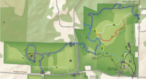
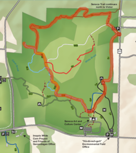
This Sunday, Springwater Trails will return to the trails of Ganondagan State Historic Site. This is a favorite location for hiking with trails contributed by the Friends of Ganondagan and by .Victor Hiking Trails. Our hikes will include the Seneca and Dryer trails, The Earth is our Mother Trail and the Trail of Peace, and will include both wooded and open grass areas, plus flat and hilly terrain. We will lead two hikes on  Sunday, a loop trail that will return to the Seneca Parking Lot (about 2.5 miles), and a through hike on the Seneca and Dryer trails to the Granary Hill and the Fort Hill parking lot on Boughton Hill Rd.(about 4 miles). We will stage a couple of cars to bring us back to the Seneca Trail Parking lot.

Through Hike. Click on the image for more details and to print.

Following the hike, we will gather at the Irish Mafia for a brewery social.

Directions To the Seneca Trail Parking.

From Springwater: From the light, head north on 15A. In 0.8 miles, turn right on Wheaton Hill Rd. Then turn left onto Canadice Rd (Livingston CR 42). Bear right to stay on CR 42, which becomes Ontario CR 37. Stay on CR 37  crossing NY 20A near Honeoye. At the 4-way stop, turn right onto Richmodn Mills Rd (CR 15) across Honeoye Creek. Take the first left onto CR 40 (Allens hill Rd). Follow CR 40 for 7.6 miles, crossing US 20 in Bloomfield. Turn right onto Main St, then left onto NY-444 N (Elm St). In 4.8 miles, after passing Boughton Hill Rd at a 4 way stop, the parking lot will be on the left across from Silverton Glenn Rd before you get to the village of Victor.

From Canandaigua: Take NY 332 north for about 7 miles to CR 41. Turn left on CR 41. In 3.3 miles, at the 4 way stop, turn right on NY 444. In 0.7 miles, the parking lot will be on the left across from Silverton Glenn Rd before you get to the village of Victor.

From Naples, and South Bristol: take NY 64 north for 13 miles. Turn left onto US-20, at the light (the Irish Mafia Brewery is straight ahead on the right), then right on  NY 444 (in 1.2 miles). In 6 miles, the parking lot will be on the left.

From Rochester and Victor: Take I-490 East, taking Exit 29 onto NY 96 into Victor. Turn right onto Maple Ave in the center of Victor. In 0.9 miles, the parking lot will be on the right.

Directions to the Irish Mafia.

From the Seneca Trail Parking Lot: Head south on NY 444. In 6 miles, turn left on US-20. In 1.2 miles at the light, turn left onto Whalen Rd. The Brewery is on the right (the second building).

Posted on by

NO HIKE – Christmas Day

Merry Christmas and Happy Holidays.

There will not be any hike this Sunday. We hope many of you will be enjoying your own favorite hike with your family or friends.  We will see you next year (next Sunday) for our traditional 1st day hike at Canadice Lake.

Posted on by

Oatka Creek Park hike

Oatka Creek Park is a hidden gem of the Monroe County Park System, a smaller property perfect for a fall hike or winter ski.

Highlights include mature woods, isolated meadows, beautiful view of Oatka Creek, and the visible remains of the gypsum mines, which operated in the hamlet of Garbutt until the 1930’s.

https://www.townofwheatland.org/single-post/gypsum-mining-in-garbutt

We will be hiking the perimeter of the park using portions of all of the named trails, slightly over 4 miles of rolling hills.  The Naturalists may shorten the hike by skipping the steep-ish red trail loop and heading straight back to the main park at mile 3.

We will meet in the upper parking lot just off Quaker Road as the lower lot is smaller and may be used by those renting the pavilion.

Social afterward at RUSH CREEKSIDE INN, 6071 E Henrietta Rd, Rush, NY 14543

Directions: From Interstate 390, take Exit 9 (Rush) and go west on Route 251. After crossing the Genesee River, go straight ahead on Quaker Road when Route 251 turns north toward Scottsville. In about 2.25 miles Quaker Road will end in a T at the park entrance. Go straight ahead to the first parking lot.

Alternative from Springwater: Take Route 15 north to Route 251 intersection. Go west, cross river, keep going straight ahead on Quaker Road to park entrance.


Posted on by

Schribner Valley Hike

Come join us for a December hike up and down the hills around Schribner Rd. We will all meet at the Hopkins House. From there, we will split into two or three groups to enjoy both views from the top of the hills and enjoy the streams and woods at the bottom of the valley.

The Climbers will cross the road and head up through a red pine forest to the potato fields at the top on the hill. From there, we will head down to the stream and cross over in a white pine woods. After some meandering, we will return to the house for a dish to pass social.

The Tourists will wall up through an open field and then cross the road and head uphill to another potato field.  From there we will head back down to the road and enjoy some walking around the house and back to the social.

Meanwhile, the Naturalists will follow the tourists up across the field, but will turn left staying on the south west side of the road. After crossing the stream at a third location, they will walk up through pine plantations to the hardwood forest. From there, they will head down to the stream again, up by a couple of old cabins and back to the house.

Following the hike, everyone is invited to join an optional social. Please bring a dish to pass, and your beverage of choice (or make a $5 contribution to the social fund). Plates and “silver”ware and coffee will be provided, thanks to Char’s care of the social funds.

Directions: It is December, so Giles and Schribner roads are closed west of our house.  Even if there is no snow, you definitely do not want to try Schribner Rd from Strutt St. If you make it through, your car will not thank you.

Here are good winter directions. They will bring you in from Tabors Corners Rd and the house will be one mile up Schribner on the left.  There is a mailbox by the driveway and a sign post. If you come to the intersection of Giles and Schribner, you have gone about 10 feet too far. Turn around and park on the road in the intersection If you choose to park in the driveway, pull in and turn around so you can drive out without backing up in the dark.

From Springwater: Head north on Rt 15A from the light in Springwater.  Take the first right on Wheaton Hill Rd (Co Rd 16).  Turn right on Wetmore Rd at the stop sign at the top of the hill.  At the end of Wetmore, bear right on Tabors Corners Rd.  After 3.5 miles turn right on Scribner Rd.  The driveway is the 2nd driveway on the left one mile up Schribner Rd and about 10 feet before the intersection with Giles Rd. Turn around at the intersection and park on the west side of the intersection..

From Wayland: From Rt 15, head east on Rt 21 toward North Cohocton for 3 miles. Turn left on Tabors Corners Rd (Steuben Co Rd 37).  After 2 miles, turn left on Schribner Rd (the second left).  The driveway is the 2nd driveway on the left one mile up Schribner Rd and about 10 feet before the intersection with Giles Rd. Turn around at the intersection and park on the west side of the intersection.

From Honeoye: From Rt 20A, head south on Ontario Co Rd 37.  At Canadice, continue straight ahead on Canadice Hill Rd as Co Rd 37 turns right. When Ross Rd bears to the right, stay on Canadice Hill Rd straight  ahead past Harriet Hollister Spencer Park. At the Springwater Town Line Rd, continue straight ahead on Wetmore Rd. Stay on Wetmore up over the hill to the end (total distance from 20A to the end of Wetmore Rd is 10.7 miles). Bear right on Tabors Corners Rd.  Turn right on at 3.5 miles on Scribner Rd.  The driveway is the 2nd driveway on the left one mile up Schribner Rd and about 10 feet before the intersection with Giles Rd. Turn around at the intersection and park on the west side of the intersection.

From the East Lake Rd in Honeoye or From Naples: Rather than traveling north to reach 20A or Co Rd 37, hikers from east of Honeoye Lake may go south to Ontario Co Rd 36 and follow Co Rd 36 to Naples. Turn right on Rt 21 south.  Turn right to stay on Rt 21 for 4.5 miles to N Cohocton.  Turn right to stay on Rt 21 towards Wayland.  After 3.8 miles turn right on Tabors Corners Rd (Steuben Co Rd 37).  After 2 miles, turn left on Schribner Rd (the second left).  The driveway is the 2nd driveway on the left one mile up Schribner Rd and about 10 feet before the intersection with Giles Rd. Turn around at the intersection and park on the west side of the intersection.