Posted on by

Highland Park Spring flowers

Spring is here and trees and flowers are blooming. Springwater Trails will explore Highland Park in Rochester, the site of Lilac Festival held on May 12-21, 2023. We likely will see many lilacs this early, but there should be plenty of other blossoms including daffodils and magnolias.

This hike will be on grass and sidewalks and will include various rolling hills. We will break into two groups and each group can adjust their route based on terrain and hiker’s interest.

The climbers will follow a 3 mile route reaching all corners of the park. We will start at the parking area in front of the castle (directions below). A short walk behind the castle will bring us to the Sunken Gardens. From there we will walk around the houses in the area and explore the park land between Reservoir Ave and Robinson Drive, passing above the Bowl and crossing South Avenue. From there we will head to the Poet’s Garden.  I am planning to head across Highland Ave to see some of the various memorials that have been created.  Returning to to lilacs, we will head for the Rhododendrons which bloom earlier than the lilacs, if I remember correctly. From there I plan to cross Pinetum Drive for a view over the city, and then make our way west, and explore north of Robinson Drive. to end up back at the cars.  If time permits, we will cross Mt Hope and visit the Susan B. Anthony grave site.

The Tourist/Naturalists will follow the same route through the sunken gardens and around by the Bowl to the Magnolias. They will follow the sidewalk around the reservoir, down to the Pansy Bed, back up to the Azaleas and out  to Reservoir Ave. The group can the decide whether to walk the sidewalk back to the cars (about 2 mi. total), or explore behind the Conservatory and continue back around the Bowl to the cars (about 2.5 miles).

Social: Following the hike, we will gather at The Distillery Restaurant 5 blocks south on Mt Hope Ave.

Directions:

From Springwater center: Head north on NY 15A toward Hemlock. Stay on 15A all the way to Rochester. After crossing the canal, continue straight across Westfall Rd, and then bear left to stay on East Henrietta Rd. Bear right onto Mt Hope Ave. Continue for about 3/4 mile, and turn right onto Reservoir Ave (first street after the light at Highland Ave). Take the first left into the park and park in front of the castle.:

From I-390 and points south and west:  At the intersection with I-590, stay left to keep on I-390.  Stay in the right lane and take Exit 16B to merge onto NY-15A. Continue straight across Westfall Rd, and then bear left to stay on East Henrietta Rd. Bear right onto Mt Hope Ave. Continue for about 3/4 mile, and turn right onto Reservoir Ave (first street after the light at Highland Ave). Take the first left into the park and park in front of the castle.:

From I-490, Victor and points south and east: Take I-490 west to Exit 17 (Goodman St). Turn left onto Goodman St and continue for 0.8 miles. At the top of the hill, turn right into the park on Pinetum Rd. Turn left then right onto Reservoir Ave. Cross South Ave and turn right into Castle Park. Park in front of the castle.:


Posted on by Posted on by

A Hike on the Bristol Hills Branch of the FLT in Naples

The walk this Sunday  will be a hike of our section of the Bristol Hills Branch of the Finger Lakes Trail in Naples. Springwater Trails has signed up with the FLT to maintain this part of the trail.  This segment passes through the West Hill Preserve off Seman Rd and then across private land to Mt Pleasant Street in Naples. The Twisted Branch Trail Run comes over this section later in the year; a couple of hundred runners will be pounding the hill and we want to be sure the trail is safe and fun to run.

We will walk this stretch of the BHB and cut away any brush and weeds that have overgrown the path. The most useful tools for this are lopers and a small saw. There’s usually several large trees down after the winter; we’ll make a note of these and come back with a chain saw to clear them another day. Be sure to wear good work or gardening gloves. It’s a fairly long hike and steeply downhill at the Naples end of the walk.

The Climbers will walk all the way from Seman Road to the Village of Naples. This is a long walk of about 5 miles and is fairly steep coming down into the village, but the weather looks to be dry this weekend reducing the risk of slippery mud.

The Tourists will hike the section of the trail on Nature Conservancy land, turning around at the FLT sign-in box where the trails moves to private property. This is about 2.5 miles.

The Naturalists will follow the same trail at least as far as the wetlands, and as much more of the trail as they are comfortable with.


We will meet at the entrance to the West Hill Preserve on Seman Road (42.66166, -77.396288). We will shuttle some cars down to the hike end in Naples (42.625950, -77.397304) before we start.


Please note: Dogs are not allowed to hike on the Nature Conservancy property.

Another Note:  When I last looked a couple of weeks ago there were several pieces of heavy equipment blocking the small parking area at the trailhead. If they are still there we’ll have to park along the road. Please park carefully and along one side only – the road is the minimum width a two-lane road can be.


The Social 

The social with be at the Middletown Tavern at 183 S. Main Street in Naples.


Directions to the Hike Meeting Point: 

From Springwater: Head south on NY 15 (for 5.2mi). At the light in Wayland turn left on NY 21N (for 6.7mi). In N Cohocton, turn left to stay on NY 21N (for 4.5mi). In Naples, turn left again to stay on NY 21N (for 1.8mi). On the north side of Naples, turn left on CR12 and head up the hill for 1.9 miles.  Take the first left, Rhine St., to the 4 way  intersection.  Go left onto Seman Rd.  Trailhead is about 1/2 mile, by a big sign on the left. Park along the road.

From Honeoye and Naples: Head south on CR 36 on the west side of Honeoye Lake (it’s 13.6 miles from NY 20A, and 1 mile from French Hill Road). Turn left onto Gulick Rd (for 2 mi), then right on Davis Rd (for 0.7mi). At the end of Davis, turn left on W Hollow Rd (CR 33) for 0.5mi, then right on Seman Rd. The Trailhead is about 1 mile, by a big sign on the right. Park along the road.


Directions to the social: From Seman Road, come down to Route 21 in the Village of Naples and turn right (that’s Main Street going South). The Middletown Tavern is on the left across from the gas station..

Posted on by

High Tor in Early Spring

Next Sunday’s hike will take us to this Wildlife Management area run by the DEC Division of Fish and Wildlife for the purposes of conservation and recreation. A “tor” is by definition a hill or mound, therefore not much flatland for hikers. However, I have done my best to accommodate our 3 levels of hikers for this outing.

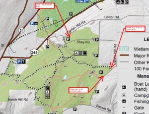
Meeting Place Large parking area on Basset Rd. Naples. From Rt. 21 in Naples, heading south, bear left on Rt. 53.. In about .75 miles, turn left on County Rd. 21. aka Italy Valley Rd. Basset Rd is a left turn, about 2 miles east. The parking area is on the left, about .5 miles down.

Hiking Groups All hikers will start together on a gravel forest road which leads from the same point in the parking area. We will head north on the gravel road, soon passing through a gate and bear left and pass by two nice ponds, then head uphill on a gradual grade through the woods. When we reach the intersection where the orange trail (the Bristol Hills Branch of the FLT) enters from the left, hikers can split into separate routes.

The Climbers will turn left and follow the orange trail to the first intersection with the blue trail. At that point they will turn to the left to follow the blue trail down to East Hill Rd.  Cars will be waiting to  ferry climbers back to the Basset Rd parking lot.

The Tourists will turn right to follow the gravel road east to a gate, where they will turn right to head back down to the parking lot.

Meanwhile the Naturalists will continue straight on the gravel road. They may continue to the DEC lean to with an overlook of Canandaigua Lake. But the Naturalists should check their watches and turn about to arrive back at the parking lot at around 4:00.

Social Following the hike we will meet at Middletown Tavern on the corner of Main Street (Rt 21) and Clark St. (Co.Rd 36).

Directions: From the intersection of NY 21 and NY 53 at the south end of Main St in Naples, follow NY 53 south for 0.8 miles. Turn left onto Italy Valley Rd (CR 21). In 2.1 miles turn left onto Basset Rd. In 0.3 miles and after the road turns right, the parking lot will be on the left.

Directions to the social: Follow Basset Rd, Italy Valley Rd and NY 53 back to Naples. Continue straight onto NY 21 (Main St). The Middletown Tavern is on the left across from the gas station..