Posted on by

Mendon Ponds Park Hike

Join us on Sunday Nov 19th for a Fairy decent hike.   Everyone will meet at the Nature Center parking area at 27 Pond Road, Mendon at 1:45 for a 2PM start.

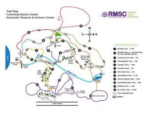
Naturalists will explore the Nature Trail and parts of Birdsong and Quaker Pond Trails. Birdsong and the Nature Trails are noted for feeding the chickadees from your palm so bring some birdseed and give it a try.  This hike is a loop with a length of about 1.5miles with the option to add another 1/4mile loop towards the end.

Climbers will start on the Nature Trail, cut over to the Grassland and Devil’s Bathtub trails, West Esker Trail, Kennedy Bog and back to see the Fairy Houses(see above) on the Nature Trail. Hike length is about 3.3 miles.


        Please note: Climbers will experience several steep ascents and descents. Hiking poles are recommended.

 
Mendon Ponds Park map

Social afterwards at Flaherty’s Restaurant, 60 W. Main Street, Honeoye Falls.


Directions to Nature Center:

From Springwater: Head north on 15A for 21.6 miles through Hemlock and Lima. Take a right at the exit to Honeoye Falls. Stay on W Main St into the village where you will join NY 65 (1.9 mi). Continue straight onto NY 65 for 4.4 mi. (At 2 miles, you will go around a traffic circle. Stay on NY 65.) Turn right onto Pond Rd at the first park entrance. The Nature Center is just inside the entrance, on the right.

From Honeoye, take US 20A west and head north on CR 37 for 8.2 miles to W Bloomfield. Continue straight on NY 65 for about 3 miles, and make a right on Quaker Meeting House Road just before you come into Honeoye Falls. When Quaker Meeting House Road ends at Route 251 (Rush-Mendon Road), go left and then right on Route 65/Clover Street. The Pond Road entrance to the park is about 2 miles to the north, on the right. The Nature Center is just inside the entrance, on the right.

From Rochester: Exit I590 at Monroe Ave toward Pittsford. Turn right (south) onto NY 65 (Clover St). In about 6.7 you will come to the Canfield Road entrance to the park – this is not the one you want. Continue another 1.5 miles, then turn left onto Pond Rd, the second entrance into the park.  The Nature Center is just inside the entrance, on the right.

Directions to Flaherty’s for Social:  From Nature Center parking lot, go left to Clover Street (Route 65) and then left toward Honeoye Falls. Proceed about 5.5 miles to Honeoye Falls and through the center of the village. Flaherty’s will be on your left at #60 W. Main Street, which is Route 65.

Posted on by

Harriet Hollister Spencer Park Hike

Join us for a 2pm hike at the Harriet Hollister Spencer State Recreation Area. Harriett was a Rochester horticulturist, rose expert and civic leader. Over 600 acres in the park was donated to New York State from her estate in the 1960’s. It is part of the New York State Park System. There is a panoramic view of the countryside from the Overlook Trail. On a clear day, the Rochester skyline is visible. For some, this will be a familiar destination, for others an opportunity to explore a variety of trails through the forest with some intriguing terrain. As usual we will gather at 1:45 at the designated parking area to welcome everyone and to form our hiking groups. Maps will be provided to hike leaders.


Naturalists will head out on Bear Cub to the Chalet Trail. Chalet is an old road that once led to a large chalet and cabins which housed a camp at one time. Two of the old red cabins are still standing. This group will cross a few bridges, pass a pond, and make their way to the great scenic view Overlook.  Then it’s a half mile hike up Overlook Rd to return to the starting point. Total mileage about 2.8 miles.

Climbers/Tourists will also start with Bear Cub and on to Chalet TrailThen its on to Blue Spruce, Upper and Lower Sidewinder, Racoon, Fox Run and they will also enjoy a stop at the famous Overlook. Total mileage is about 4.2 miles.
The weather forecast for Sunday includes rain throughout our hiking period.  In case the forecast is correct, the following shorter hikes will be followed:
Naturalists will follow white flag markers, starting on Bypass Trail and on to Chalet Trail. Chalet is an old road that once led to a large chalet and cabins which housed a camp at one time. Two of the old red cabins are still standing. If this group chooses, they can get a closer look or continue on, passing through old pines and make their way to the great scenic view Overlook.  Then it’s a half mile hike up Overlook Rd to return to the starting point. Total mileage about 1.6 miles.
Tourists will follow yellow flag markers to Chalet TrailThen it’s on to Deer Run(full of twists and turns), pass a pond, then on to Pine Trail. They will also enjoy a stop at the famous Overlook. Total mileage is about 2.5 miles.
Climbers will travel with Tourists to Chalet Trail but turn down Doremus Trail. Then it’s on to Hill & Valley, Red Spot(tree markers have big red spots). They head back following a trail below Overlook Rd. still being able to glimpse the great scenic Overlook.   Total mileage is about 2.7miles

Social: Following the hike please join us for some food/drink at the Birdhouse Brewing Company, 8716 Main Street, Honeoye .

Directions  (6775 Canadice Hill Road, Springwater, NY)
From Springwater: Take Rt. 15A and turn up Wheaton Hill Rd. Drive all the way to Wetmore Rd. and turn left. Continue straight onto Canadice Hill Rd. and drive another 2 miles to the park on the right.
From Rochester: Take 390 South to Exit 10 (5&20). Turn left onto Rt 5&20 and head towards Lima. Turn right on Rt 15A thru Hemlock. Turn left on Rt 20A  and head towards Honeoye. Turn right on County Rd 37. Continue on 37 straight onto Canadice Hill Rd. The main parking lot is 3 miles down on your left.
From the Southern tier: Take 390 North to Wayland Exit 3. Turn right on Rt15. Head north to Springwater. Go straight onto Rt 15A. Take Rt. 15A and turn right up Wheaton Hill Rd. Drive all the way to Wetmore Rd. and turn left. Continue straight onto Canadice Hill Rd. and drive another 2 miles to the park on the right.
To the Social: From the park, return to the north on Canadice Hill Road and County Road 37, to Route 21A. Make a right and go down the hill and into Honeoye. A few doors past the light, the Birdhouse Brewring Company is on the left at #8716.
Posted on by

Hatch Hill, from Naples to Conklin Gully

The Sunday hike on October 22nd 2023 we will walk the FLT on Hatch Hill in Naples; the Fall colors should still be strong for this hike.  The hike will start at the Bob North bridge at the bottom of Ontario Street in Naples. There is a kiosk and a small parking lot there, and all groups will start at the same place. The Naturalists will walk along Matt’s Meander to the Naples Community Park and back, while the Tourist will walk south along Hatch Hill above the town to the south end of Naples. The Climbers will walk north on Hatch Hill to Conklin Gully. Both Tourists and Naturalists will walk back to the parking lot, while climbers will end up at the DEC parking area at the bottom of Conklin Gully and be shuttled back to Naples. Note: the last half mile of this hike is a very steep downhill, but it’s worth it; there are huge drops into the gully to the right of the trail, and wonderful view across the gully and down into it.

There is a DEC display board at the parking lot with a map of all the trails that meet there; all the day’s hiking trails are shown.


NaturalistsNaturalists at Hi Tor

The Naturalists will cross Naples Creek on the Bob North bridge and bear to the left. It is a broad path through woods with the Naples Creek flowing to the left of the path. This trail is called “Matt’s Meander”, and it follows Naples Creek to the Community Park on Route 245. It is about a mile to the end of the trail and back.

Tourists

The tourists will cross the bridge and bear to the right. The trail runs south along Hatch Hill above Naples Creek, and goes parallel to both Naples Creek and Naples Main Street, though a lot higher up the hill. This path is not blazed or marked at all but it is well trodden for most of the way; it becomes a little harder to see at the southern end, but once the Turkey Federation parking lot is in sight then it’s not hard to find a way down to it. The trail passes through land that was once grazed and then terraced for vines, but is now returning to woodland. Traces of the shallow terracing for the vineyards can be seen all along the trail, and occasionally an abandoned farm building. The creek can be seen in the valley below the trail all the way along. This trail ends at the south end of Naples, on Mark Circle, where several streams come together to form the Naples Creek. There is water supply facility there, a swimming hole, and an antiques shop. The group will return to the Ontario Street parking lot via Naples Main Street. This walk is 2.1 miles. with just one short modestly steep section.

Climbersnaplesclimbersweb2

The Climbers will take the Finger Lakes Trail to Conklin Gully through the High Tor Game Management Area. They will cross the bridge and bear left along with the naturalists, and then about half way down Matt’s Meander the FLT branches off to the right. The group will follow the ORANGE blazes on a long uphill section; it’s steep in places with some switchbacks – the trail seems to be going the wrong way at times. There are some ponds at the top of the hill (it’s a mystery – where does that water come from?) with the Howard Beye memorial bench on one of them. It’s important to stay with the orange blazes here – there are several logging roads that make it easy to take the wrong path. Where the trail meets the top of Conklin Gully there is a lookout with a fine view of the Naples Valley and a well organized scout camp, complete with fire pit. The path down the hill from the camp is broad and easy walking. The group will leave the FLT where it branches off to the right over a bridge to the memory of Tom Noteware and follow the BLUE blazes down the hill to the DEC parking lot at the bottom of Parrish Hill.


The Meeting Place

We will meet at the trail head parking lot on Ontario Street, Naples, at 2:00pm. The climbers will shuttle some cars to Parrish Hill before starting off.

Getting There

From Springwater and Wayland, come south on Rt. 15 to the traffic light at Rt 21. Turn left on 21 and keep going all the way to Naples. Go through the downtown business area and turn right on Ontario Street, opposite the school. Go to the bottom of the hill and the parking lot is on the left.

From Dansville, follow Rt. 63 to Wayland where the road turns into Rt 21; continue on 21 all the way to Naples. Go through the downtown business area and turn right on Ontario Street, opposite the school. Go to the bottom of the hill and the parking lot is on the left.

From Naples, go to the school on Main Street (Rt. 21). Turn down Ontario Street opposite the school, go to the bottom of the hill and the parking lot is on the left.


The Social

The social will take place at the Middletown Tavern, 183 S main Street in Naples

.