
Hikes led by Springwater Trails are generally held on Sunday afternoons and appear in this calendar in green.
| Sun | Mon | Tue | Wed | Thu | Fri | Sat |
|---|---|---|---|---|---|---|
| Dryer Road Park and Ganondagan 4:00 pm Dryer Road Park and Ganondagan @ Dryer Road Park Jul 7 @ 4:00 pm – 6:00 pm  CHANGE OF VENUE FROM THE EARLIER PUBLISHED HIKE: This Sunday we will be hiking in and around Ganondagan State Historic Site in Victor, with initial meeting and a pot-luck social at nearby Dryer Road Park. The three groups will have … Continue reading | Spotted Lanternfly and Other Invasive Landscape Tree Pests 12:00 pm Spotted Lanternfly and Other Invasive Landscape Tree Pests Jul 8 @ 12:00 pm – Jul 16 @ 1:00 pm  Webinar: Tuesday July 16 2019 at 12:00 Noon Register here Speaker: Dr. Lori Spears, USU Assistant Professor Date: Tuesday, July 16, 12:00 pm (MDT) – Please ignore the date in the title; it is an unavoidable posting date and NOT the … Continue reading | Japanese Barberry 9:00 am Japanese Barberry @ Cumming Nature Center Jul 11 @ 9:00 am – 2:00 pm Volunteers Needed for Invasive Species Restoration Team! Cumming Nature Center is seeking volunteers to help restore its nature preserve in Naples, NY, this summer, with a kickoff event during Invasive Species Awareness Week! Join us on Thursday, July 11, 2019, … Continue reading | ||||
| Keuka Outlet Trail Hike or Bike 4:00 pm Keuka Outlet Trail Hike or Bike @ Seneca Mill Access Parking Area Jul 14 @ 4:00 pm – 6:00 pm  This Sunday people will have the choice of bike riding the Keuka Lake Outlet Trail or hiking a section of it. The trail follows Keuka Lake’s outlet to Seneca Lake, starts in Penn Yan and goes approximately 7 miles to … Continue reading Spotted Lanternfly and Other Invasive Landscape Tree Pests 12:00 pm Spotted Lanternfly and Other Invasive Landscape Tree Pests Jul 8 @ 12:00 pm – Jul 16 @ 1:00 pm Webinar: Tuesday July 16 2019 at 12:00 Noon Register here Speaker: Dr. Lori Spears, USU Assistant Professor Date: Tuesday, July 16, 12:00 pm (MDT) – Please ignore the date in the title; it is an unavoidable posting date and NOT the … Continue reading | ||||||
| Fairport Canal Paddle, Hike, or Bike 4:00 pm Fairport Canal Paddle, Hike, or Bike @ Erie Canal Boat Launch Jul 21 @ 4:00 pm – 6:00 pm This week Springwater Trails will return to the Erie Canal for a walking, biking, or kayaking tour of the Erie Canal through Fairport, NY. The Town of Perinton was established by the New York Legislature in 1812. When the Erie … Continue reading | Finger Lakes Trail Days – Opening Concert 6:00 pm Finger Lakes Trail Days – Opening Concert @ Steuben County Fairgrounds Jul 26 @ 6:00 pm – 9:00 pm The Steuben County Fairgrounds in Bath, NY will be transformed into a celebration of all things outdoors on Friday, July 26. The Finger Lakes Trail Conference along with the Steuben County Conference & Visitors Bureau and Friends of the Chemung … Continue reading | Finger Lakes Trail Days – Day 2 8:30 am Finger Lakes Trail Days – Day 2 @ Steuben County Fairgrounds Jul 27 @ 8:30 am – 10:00 pm The Steuben County Fairgrounds in Bath, NY will be transformed into a celebration of all things outdoors on Friday, July 26. The Finger Lakes Trail Conference along with the Steuben County Conference & Visitors Bureau and Friends of the Chemung River is excited to present the … Continue reading | ||||
| Naples/Tannery Creeks/Grimes Glen 4:00 pm Naples/Tannery Creeks/Grimes Glen Jul 28 @ 4:00 pm – 6:00 pm 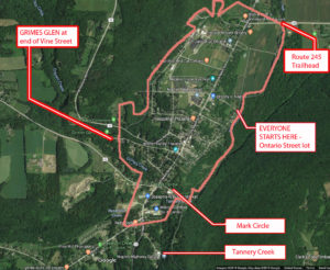 42.617844, -77.396354 (Ontario St. Parking Lot) This Sunday we will hike trails on the outskirts of the Village of Naples. The first is the Naples Creek Trail, which follows the eastern edge of Naples … Continue reading |
Webinar: Tuesday July 16 2019 at 12:00 Noon
Speaker: Dr. Lori Spears, USU Assistant Professor
Date: Tuesday, July 16, 12:00 pm (MDT) – Please ignore the date in the title; it is an unavoidable posting date and NOT the date of the webinar!
The spotted lanternfly has been identified as a nasty invasive insect that is busy killing trees in Pennsylvania. The forestry and university authorities in PA have launched a series of webinars aimed at educating hikers such as ourselves in identifying and reporting these marauders. There’s is one coming up on 16th July; you are invited to join in from the comfort of your own home – we may be able to help limit this beast in New York.
Spotted lanternfly is an invasive planthopper that is native to parts of Asia and was first detected in the U.S. in Pennsylvania in 2014. Spotted lanternflies feed on a wide range of host plants, including grapes, fruit trees, hops, and hardwood ornamental trees. This presentation will cover the biology, identification, and possible control options for spotted lanternfly and other invasive landscape tree pests, such as emerald ash borer and Asian longhorned beetle.
Lori is the Cooperative Agricultural Pest Survey (CAPS) Program Coordinator at Utah State University. The CAPS Program is a federal program coordinated by the United States Department of Agriculture (USDA) Animal and Plant Health Inspection Service (APHIS) Plant Protection and Quarantine (PPQ), and whose goal is to protect U.S. agriculture from introductions of high risk invasive pests by conducting early detection surveys and providing outreach and education programs that support and enhance efforts to prevent new exotic pest entry and establishment. Her research and outreach programs have focused on the ecology and management of invasive insects and using bycatch from early detection surveys to learn more about beneficial insects, such as pollinators and lady beetles. Lori received a PhD in Ecology from Utah State University in 2012.
Co-sponsored by Utah State University Integrated Pest Management Group
|
|||||||||||||||
Volunteers Needed for Invasive Species Restoration Team!
Cumming Nature Center is seeking volunteers to help restore its nature preserve in Naples, NY, this summer, with a kickoff event during Invasive Species Awareness Week! Join us on Thursday, July 11, 2019, from 9 am to 2 pm, to help remove Japanese Barberry! Please contact Cumming Nature Center at (585) 374-6160 to sign up or for more information! Cumming Nature Center is located at 6472 Gulick Road, Naples, NY.
Cumming Nature Center seeks large and small groups, as well as individuals, to help remove Japanese barberry infestations so that we can seed native plants, restore native habitats for wildlife, and protect the surrounding Honeoye Lake watershed. Japanese barberry is an invasive shrub which is spreading throughout our Naples preserve, harming and eliminating our native habitats. We welcome everyone to come join our ongoing Restoration Team!
Please wear long work pants, long sleeves, socks, and boots or work shoes, since removing Japanese barberry is somewhat like working with rose bushes. And bring a water bottle and lunch! Cumming Nature Center will provide directions, equipment, and protective gloves and gear, so that we can work efficiently to combat this invader! CNC will have water available and provide light refreshments after..
Can’t make this event? Further invasive removal events at Cumming Nature Center are listed below:
Saturday, July 20, 2019
Thursday, August 1, 2019
Saturday, August 10, 2019
Sunday, August 11, 2019
Saturday, August 31, 2019
Saturday, September 7, 2019
Thursday, September 19, 2019
Saturday, October 5, 2019
Thursday, October 17, 2019
Saturday, November 2, 2019
— Cumming Nature Center
This Sunday people will have the choice of bike riding the Keuka Lake Outlet Trail or hiking a section of it. The trail follows Keuka Lake’s outlet to Seneca Lake, starts in Penn Yan and goes approximately 7 miles to Dresden dropping 275′ along the way.
This trail runs along the stream in a wooded ravine, it was “formerly a canal towpath and later a rail road bed, it crosses the original Pre-Emption Line and passes near the area of the first permanent white settlement of ‘The Universal Friend Jemima Wilkinson’, along waterfalls and ruins of mills, factories and canal locks”.
 Everyone will meet at the Seneca Mill Access parking area on Outlet Road at 4:00 PM. From there, bikers can go out and back both ways on the trail for a total of up to 14 miles. Well suited for hybrid or mountain bikes, the trail is a combination of dirt, gravel and asphalt and somewhat uneven. Hikers will divide into two or three groups depending on how far people choose to hike in the two hours that they have. All groups should plan to take in the Seneca Mills & Falls site (.2 miles west of the parking area) and the Cascade Mills & Falls site (1 mile east of the parking area).
For those who would like to get something to eat and drink before heading home, meet at the Silver Bird Woodfired Pizza at 133 E Elm Street, Penn Yan. If the weather is nice we will probably eat out on the deck. Check out their website and preview their menu.
Some maps of the outlet trail will be available at the beginning of the hike: you can print your own map from the The Friends of the Keuka Outlet Trail website.
Directions:
From Springwater, Wayland and Naples. Head south from Springwater on NY-15 south to Wayland, then turn left NY-21. Follow NY-21 for 12.7 miles through N Cohocton and Naples. Turn right on NY 245N across from Bob Ruth’s. Follow NY-245 for 8.9 miles to Middlesex and take a slight right turn onto NY 364E. In the Village of Penn Yan, turn right onto Liberty St., turn left onto Clinton St (State Route 54 North) and follow it 2 miles, turn right onto Bentley Rd (which becomes Bell Road) and go for 1 mile, turn left onto Outlet Road and go for .7 miles, parking area is on right.
This week Springwater Trails will return to the Erie Canal for a walking, biking, or kayaking tour of the Erie Canal through Fairport, NY. The Town of Perinton was established by the New York Legislature in 1812. When the Erie Canal opened in 1823 the hamlet of Perrinsville grew steadily around the “fair port” on the canal that marked the east side of the crossing of the Irondequoit Creek. The hamlet was incorporated as Fairport in 1867.
All hikers, bikers and boaters will meet at the boat launch on Ayrault Road. Please arrive early to allow time to unload boats and bikes and to park your cars in the boat launch lot. We will start the hike promptly at 4:00. Following the hike, you are invited to join us at Mulconry’s Irish Pub and Grill at 17 Liftbridge Ln E in Fairport for dinner and socializing.
In order to free up parking spaces for boaters at the boat launch, Hikers will carpool to the Fairport end of the trail. (see directions below). This hike will be an out and back, so please keep track of time. From the parking lot, head west on the Canal. Hikers will go under the lift bridge (note that the bridge is higher on one end – I think it is the only lift bridge that isn’t level). Next you will pass Erie Boat Rentals where you can rent kayaks and bikes for $21 for 2 hours. A mile down the trail is Perinton Park with swings and benches to rest. Continuing under Fairport Rd (NY 31F), the Fairport Crew Club docks will be on your left. Continue on toward Ayrault Rd until about 5:20, at which point hikers should turn around and head back to the cars and the social.
Boaters will put in at the boat launch and head north toward Fairport. In a half mile, you will see an oxbow to the right – a couple of islands with the original creek bed around them. Enjoy exploring this little harbor. Another mile ahead, you will pass under Fairport Rd (31F). The Fairport Crew Docks are on the left before the bridge, and Perinton Park is also on the left just after the bridge. The total distance to Main St in Fairport is 2.5 miles, a pleasant trip that can be completed out and back in 2 hours. However, all boaters should turn around shortly after 5:00, planning to arrive back at the boat launch at 6:00.
Bikers will ride both directions on the canal path. Leaving from the boat launch, turn right on Ayrault Rd to cross the canal. About 200 ft past the bridge, turn right on the access trail, then right on the canal path toward Bushnell’s Basin. Its about 5 miles to the Great Embankment Park on the right. From that park, turn around and ride past Bushnell’s Basin past Ayrault and continue on toward Fairport. If you turn around at the lift bridge on Main St, you will have about a 10 mile ride. Or continue on through the village to Lyndon Rd (large ramp up to the road level) means a 14 mile ride.
Directions to the meeting point at the Ayrault Rd boat launch.
From Springwater: From the flashing light in Springwater, head north on NY 15A for 13 miles. You will pass through Hemlock. When US-20A bears to the left, and 15A continues straight, you should turn right on Richmond Mills Rd (CR-41). In 4 miles, turn left onto CR-37. In West Bloomfield continue straight onto NY-65. In 0.7 miles, when NY-65 curves to the left, continue straight onto CR-35 (W. Bloomfield Rd). In 9.8 miles turn right on Thornell Rd. At the T, turn right onto NY-96. In the hamlet of Bushnell’s Basin, turn left onto Kreag Rd. Continue through the light at NY-31. At the T turn left onto Ayrault Rd. The boat launch will be on the right before the canal.
From Naples: Head north on NY-21. In about 7 miles continue straight onto NY-64 (NY-21 takes a right). Continue on NY-64 past Bristol Mountain. After 13.3 miles on NY-64, at the stop light, turn left onto US-20. In 1.3 miles turn right onto NY-444. It is 6.8 miles to Victor. Turn left onto NY-96. Stay on 96 for 2.9 miles. Take the I-490W entrance to the right. Take exit 26 for NY-31 – turn left on NY-31. At the light (0.2 mi) turn left onto Ayrault Rd. In a mile, the boat launch is on the left, just past the canal.
Directions from the boat launch to Fairport and the social at Mulconry’s: From the boat launch turn left onto Ayrault Rd. At the stop light, turn left onto NY-250. Continue through Fairport and cross the canal. Take the first right after the canal (before the railroad tracks) on Liftbridge Ln. You can park in the lot on the right between Liftbridge Ln and the Canal. Mulconry’s is across Liftbridge Ln.
The Steuben County Fairgrounds in Bath, NY will be transformed into a celebration of all things outdoors on Friday, July 26. The Finger Lakes Trail Conference along with the Steuben County Conference & Visitors Bureau and Friends of the Chemung River is excited to present the first Finger Lakes Trail Days over two jam packed days.
Kicking off the festivities Friday night is a concert featuring the Grammy Award winning bluegrass band, Steep Canyon Rangers. The duet of Rob Ickes and Trey Hensley will show off their guitar and vocal prowess warming up for the Steep Canyon Rangers.
Doors open at 6:00 pm and food and drink will be available.
Tickets can be purchased for either Friday evening’s concert or for Saturday; a two-day pass is also available. For more information on tickets, activities, on-site camping opportunities and the music schedule visit www.fingerlakestraildays.com or contact info@fingerlakestraildays.com
The Steuben County Fairgrounds in Bath, NY will be transformed into a celebration of all things outdoors on Friday, July 26. The Finger Lakes Trail Conference along with the Steuben County Conference & Visitors Bureau and Friends of the Chemung River is excited to present the first Finger Lakes Trail Days over two jam packed days.
Whether you are an outdoor enthusiast who already spends weekends hiking, biking, kayaking or fishing/hunting or someone who has always thought about trying something new, Saturday is filled with outdoor recreation activities of all kinds.
Additionally, enjoy local food, drinks, and a remarkable musical line-up. From 8:30 – 3pm there will be hikes of varying lengths and difficulty levels (click here for more information).
Also, check out the guided tours of places of interest in the area.
Beginning at 11 am at the Fairgrounds, attend one of the many interesting presentations, ranging from Geocaching to Yoga, Birdwatching to Medicinal plants and more.
Local food trucks and beer garden will be available all throughout the day.
Attendees can also experience a zip line, climb a rock wall, learn to kayak or mountain bike and navigate a ropes course.
There is a stellar lineup of outdoor exhibitors available to answer questions and provide information about their organization. Hiking groups from around the state will be available.
And meet the experts to find out more about birding, conserving land, our local rivers or monarchs.
Throughout the day you will hear a music line-up featuring Sawyer Fredericks (the 2015 winner of The Voice), Cicada Rhythm, Joshua Davis, Aaron Lipp & the Slack Tones, and Joseph Alton Miller.
There are plenty of activities for the entire family!
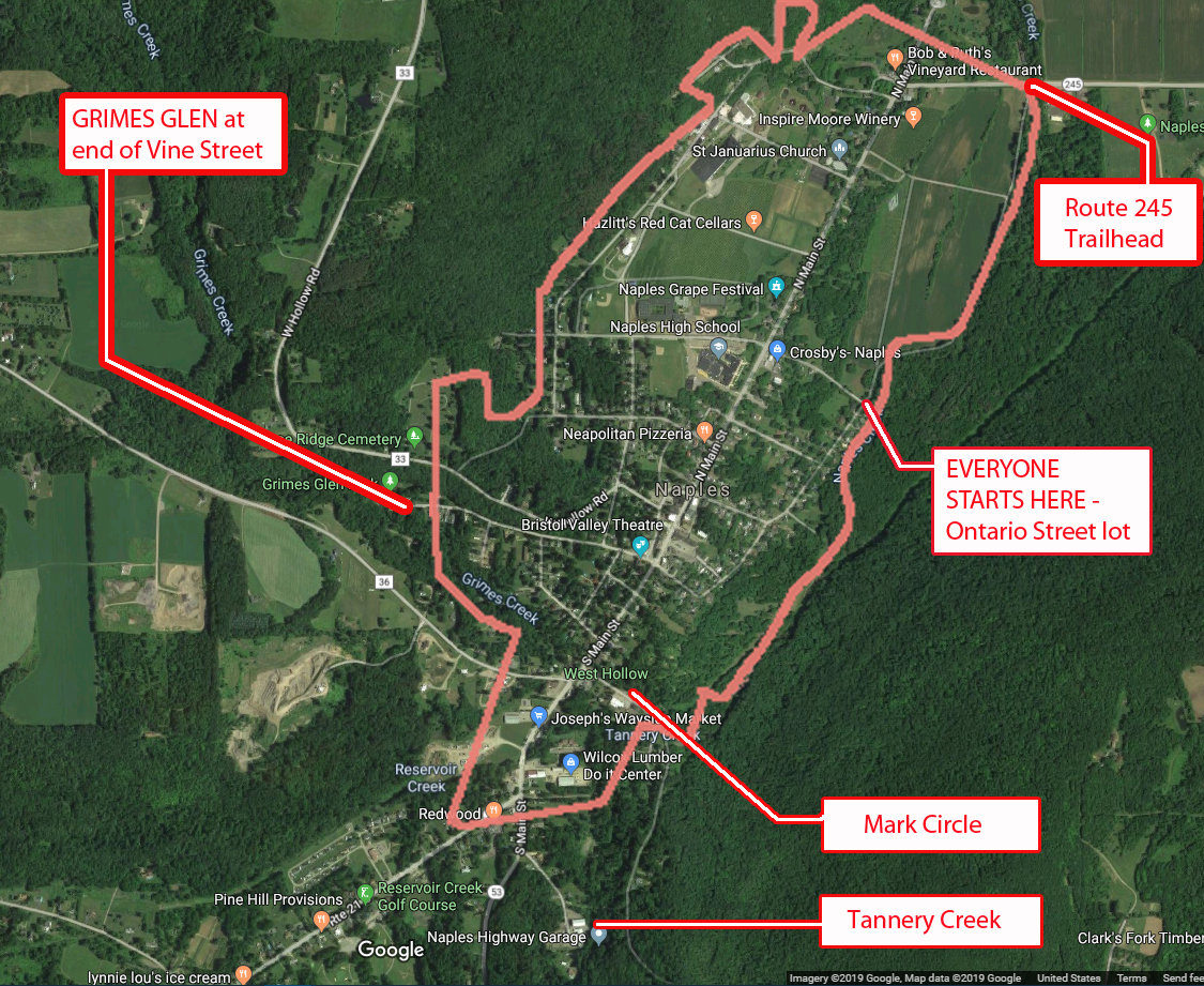
42.617844, -77.396354 (Ontario St. Parking Lot)
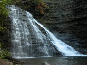
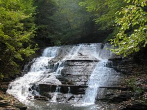
This Sunday we will hike trails on the outskirts of the Village of Naples. The first is the Naples Creek Trail, which follows the eastern edge of Naples Creek within the Hi Tor Wildlife Management Area. The second is Grimes Glen Park, a spectacular glen on the west side of the village. And for the more adventurous, the Tannery Creek Falls which features a number of waterfalls and cascades. These trails offer splendid creek-side scenery.
Tannery Creek Falls: Not as well known, or as large as its more famous companion Grimes Glen, it is another glen that is well worth the visit. Unlike Grimes Glen, there are no signs for this glen, so it gets much less traffic. Walking up the creek you will pass a couple of 10′ high falls before reaching a bigger 15′ falls. Above this is a much higher two tiered falls, around 50′ high. The trail requires some scrambling, steep ascents, and creek crossings. It is recommended that your footwear has good traction because the shale in the creek bed is very slippery. The rock walls along the creek are steep, varied, and beautiful.
1) We will need at least 4 or 5 drivers to meet at 3:35 to drop off some ‘transport’ vehicles at the Mark Circle parking lot: 42.608848 -77.403133 (Mark Circle)
Drivers will then carpool 1 mile to meet the rest of the arrivals at Ontario Street(see below). If you can be part of the transport team, please leave a comment below.
2) All hikers will then meet @ 3:45 at the parking area at the bottom of Ontario Street for check-in, maps, hiking instructions, and directions to the social.
3) We will begin the hike by crossing the bridge over Naples Creek, where we will then split up.
Naturalists will hike north along the level and picturesque Naples Creek to Rt 245, then return to starting point for a total of approximately 1.5 miles. Following this, the naturalists may wish to drive south .4 miles on Main St; turning right onto Vine Street. Grimes Glen is at the end of this street. There is a nice trail of about ½ mile to the waterfalls.
Climbers and Tourists will head south along Naples Creek for .8 miles to Mark Circle. This trail is mostly level except for a moderate climb and descent in the southern half. If there has been recent rain, there will be muddy patches.
Climbers will then carpool approx. ¾ of a mile by going back up to Main St., turning left, and continuing along S. Main Street past Joseph’s Farm stand and the Hardware store on your left. Stay on Rt 53 past the Rt 21 intersection for about 175 yards and turn left onto Tannery Creek Rd. Parking for the Tannery Creek Falls is on the right, across from the highway dept building (look for the green sign).
The trail to the creek is accessed by walking between the two buildings. Go down the bank to the creek. Cross it and continue upstream on the left side. It is necessary to cross over to the right side before climbing to the high, two-tiered falls. There are ropes provided for the steepest ascents.
Tourists will then carpool approx. ¾ of a mile from Mark Circle to Grimes Glen. To get there, from Main Street turn right and take the first left onto Weld Street. Go to the end and turn left onto Vine St., which will take you into Grimes Glen. It is a short ½ mile hike up to the falls and back.
Following the hike, please join us for an optional social at John & Susan’s (directions available at the start of the hike). Please bring a dish to pass (or make a $5 donation to the social fund), a beverage of your choice, and any musical instruments you might want to play around a campfire. Hotdogs, marshmallows, and ice-cream will be provided!
DIRECTIONS to Ontario St. parking lot https://goo.gl/maps/TbNWrqUSkZsr2E4Z
Drive up to Main St and turn right. In .67 miles, turn right onto Ontario Street. Drive down to the bottom and park on the left.
- From Springwater/Dansville/Wayland: Take Rt 21N into Naples, turning to the left at the intersection with Rt 53. Turn right in about .9 miles down Main Street onto Ontario St (across from the High School) and drive down to the parking area.
- From Honeoye: Take Rt #36 South into Naples, turn left on Main St an drive .7 miles and turn right onto Ontario St. Go down to the bottom parking lot on the left.
- From Canandaigua: Take Rt 21 South to Naples. From the intersection with Rt 245, drive approximately .5 miles along Main St. and turn left onto Ontario St. Go down to the parking area on the left at the bottom.
See 1) above for directions to Mark Circle – this is for transport vehicles only
Please Note: PURCELL HILL ROAD CLOSURE. Due to construction of a new culvert from Canadice Lake under Purcell Hill Road, Purcell Hill Road is closed from the North Parking Lot trail entrance to Canadice Lake Road. The north parking lot is open but may only be accessed from Rt. 15A side of Purcell Hill Road.
The sun will be out and Canadice Lake will be gorgeous. This week will be a choice of a paddle or a walk around Canadice Lake. Read below for driving directions to both events.
Kayakers: Please meet at 3:45 to unload boats and be in the water by 4:00. We will paddle across the lake, selecting a route based on wind and interest of the group.
Hikers: Meet at the canoe launch to select leaders and drivers to the South hiking path.
Naturalists: will walk the road around the lake observing the marsh land on the south side of the lake and the activity of the beavers on the southwestern corner of the lake.
Climbers: will hike along the lake to join Rob’s trail hiking up a portion of the trail then turn around and return to the trail head.
Social: The social will be held by the lake at the canoe launch. A table and paper products will be provided. You may wish to bring a chair to sit on at the social. There is one bench available at the site.
If you do not own a kayak, you can test the waters by renting one from Canadice Lake Outfitters at a very reasonable rate.
Rates are $20 for 2 hours; $40 for 4 hours Click here for better information. Reservations must be made in advance. Call: ( 585) 669-9512
Directions to the Hike:
Please Note: PURCELL HILL ROAD CLOSURE. Due to construction of a new culvert from Canadice Lake under Purcell Hill Road, Purcell Hill Road is closed from the North Parking Lot trail entrance to Canadice Lake Road. The North parking lot is open but may only be accessed from Rt. 15A side of Purcell Hill Road.
From Springwater: Johnson Hill access: Go North on 15A for 2.7 miles. Bear right on Old Bald Hill Rd S and then an immediate right on Johnson Hill Rd. Take the first left onto Canadice Lake Rd. The Trail-head is 1.1 miles north of Johnson Hill Rd.
From Honeoye: Take Co Rd 37 South from 20A, Turn right after 3.7mi to stay on Co Rd 37. Stay straight onto Burch Hill Rd. At the lake, turn left onto Canadice Lake Rd. The Trail-head is 2.8 miles south of Burch Hill Rd.
From Hemlock and Rochester: (This route avoids the construction) Take NY Rt 15A south from Rochester through Lima and Hemlock. Just past Hemlock, Turn left on Rt 20A. In 1.4 miles, turn right onto Canadice Lake Rd. The Canoe Launch is 6.3 miles south on the right side of the road near the south end of the lake. Note, you will pass the motor boat launch near the north end of the lake. The canoe launch is another 1.5 miles south.
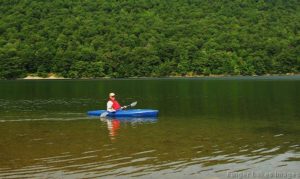
Sunday should be another perfect day to be out on the water of Hemlock Lake? Temperatures in the high seventies and a steady light wind. This week we will meet at the South Boat Launch on Hemlock Lake just miles north of the light in Springwater, and kayak north on the lake. We will cross the lake and explore the western shore. After an hour of paddling we will recross the lake and follow the eastern shoreline, possibly seeing the hikers. The eagles may even turn out to soar above us. We will kayak into the inlet until we hit a “tree block”, turn around and come back. If time we may head north for a bit on the shore of Hemlock Lake.
![]()
Attention: It is highly recommended that you bring sun glasses, suntan lotion, bug spray and water. It is going to be sunny and there is no shade on the lake!
If kayaking isn’t for you, hikers will enjoy a lovely walk along the lake, heading north from the boat launch. with several opportunities to get down to the lake and enjoy the view of the water and the opposite tree filled shore. The walk goes along the city’s access road, for about a mile each direction. You will notice many new culverts that have been installed, plus several “fords” where the water is intended to flow directly across the road. The climbers will have the option to continue on along the old road after the end of the maintained road. This involves climbing over fallen trees and possibly one narrow portion before the trail is reduced to about 6 inches wide on the edge of the bank. Total hike about 3.5 miles.
Social: Pot luck social after the hike near the parking lot. Please bring a dish to pass and your own beverage.
Kayak: Hemlock Boat Launch: South end, please arrive around 3:40 to get kayaks in the water
Hike: Hemlock trail from south end boat launch.
From Springwater: Follow 15A North from Springwater for 2.3 miles. Turn left into the parking area, then an immediate right to head down the access road. In about half a mile, the launch is on the left, and the parking area is on the right.
From Hemlock or Honeoye: Follow 15A South for 8.4 miles from the 15A / 20A intersection south of Hemlock. Turn right into the parking area, then an immediate right to head down the access road. In about half a mile, the launch is on the left, and the parking area is on the right.
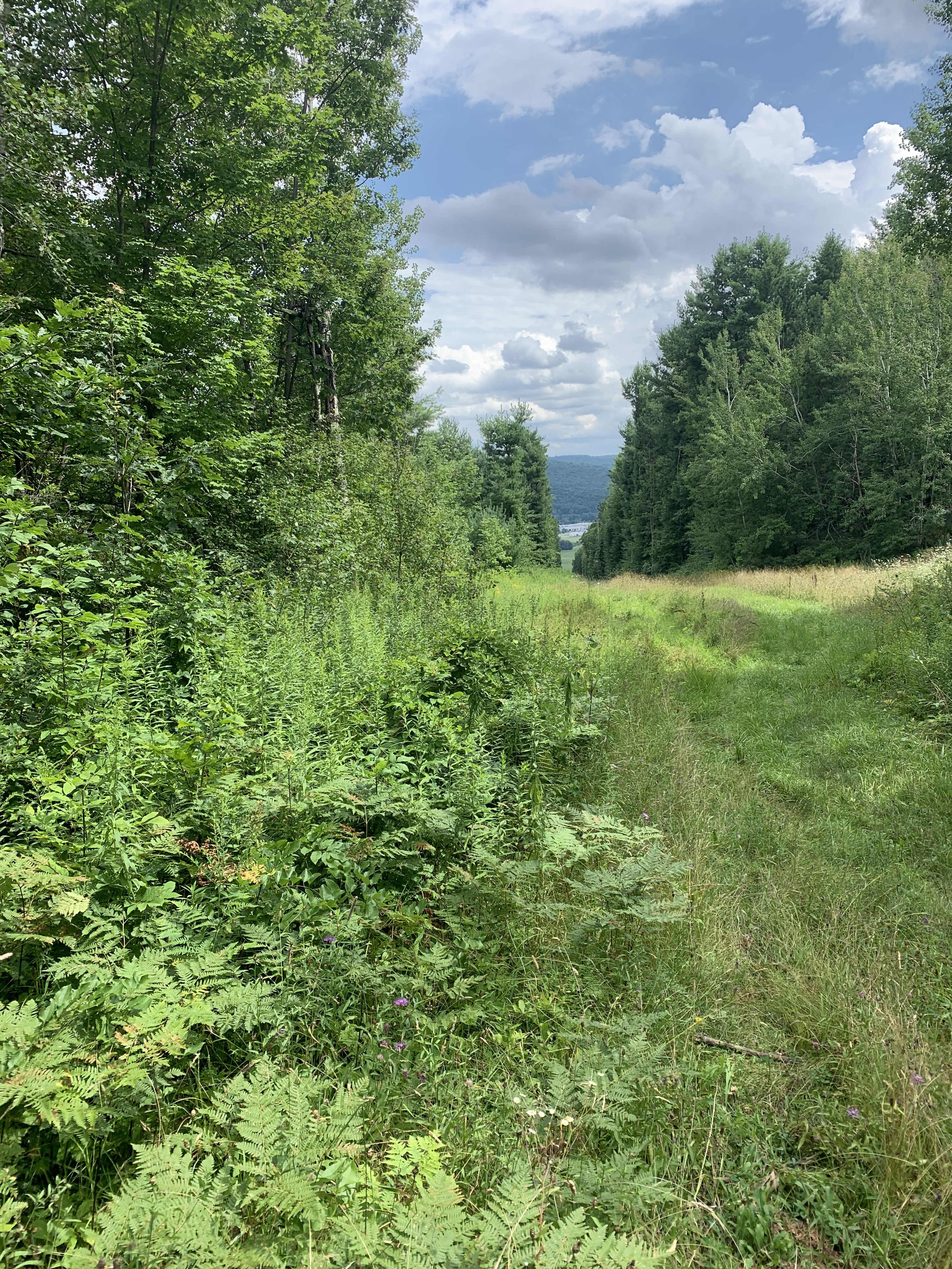
 This Sunday we start a series of hikes along the main Finger Lakes Trail between the Bristol Hills Branch and the Letchworth Branch. Previous hikes have followed each of the two branches to the east and to the west of Springwater. This series will connect the two branches along the Main Trail to the south of Springwater.
A word of warning. The trail between the two branches is 78 miles long. With one 4 mile hike each month, we would need 20 hikes to cover every mile, so I expect we will be more selective, planning to explore most of the trail (but not every mile) over the next year.
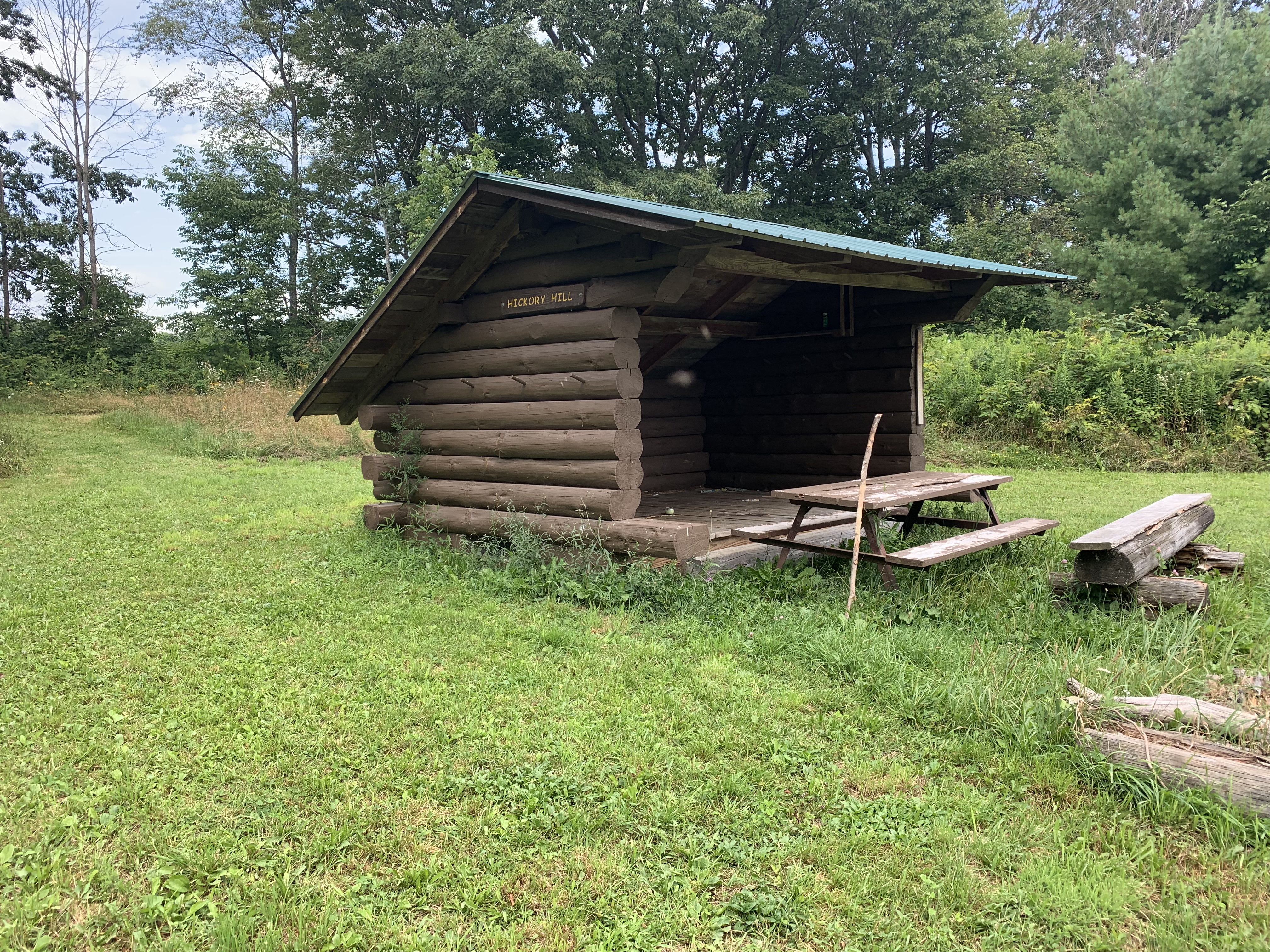
For this hike, we are offering three routes. The Climbers will start at Access 1 on Sand Pit Rd outside of Bath. They will follow the white blazes for 1.8 miles climbing some 400 feet to the Hickory Hill Lean To, where we will stop for a mid hike social – see below. Following the social, the Climbers will continue north, over Kershener Hill (1820′) to Access 2 where they will use the Tourists cars to return to the start point.(Total 3.1 miles, 550 feet up, 300 feet down)
The Tourists will carpool to Access 2 on Robbins Rd (maybe it is Barrett Rd) and will hike the reverse hike. The trail starts on a farmer’s road which heads up to a large field. Just before the field, the trail goes off to the left. If you get to the field you will see there are no more white blazes, so go back and find the branch. It is a 300′ climb to the top of Kershener Hill. At the LeanTo (1,3 miles from the start) we will stop for a social, meeting the Climbers and exchanging keys. (Total 3.1 miles, 300 feet up, 550 feet down)
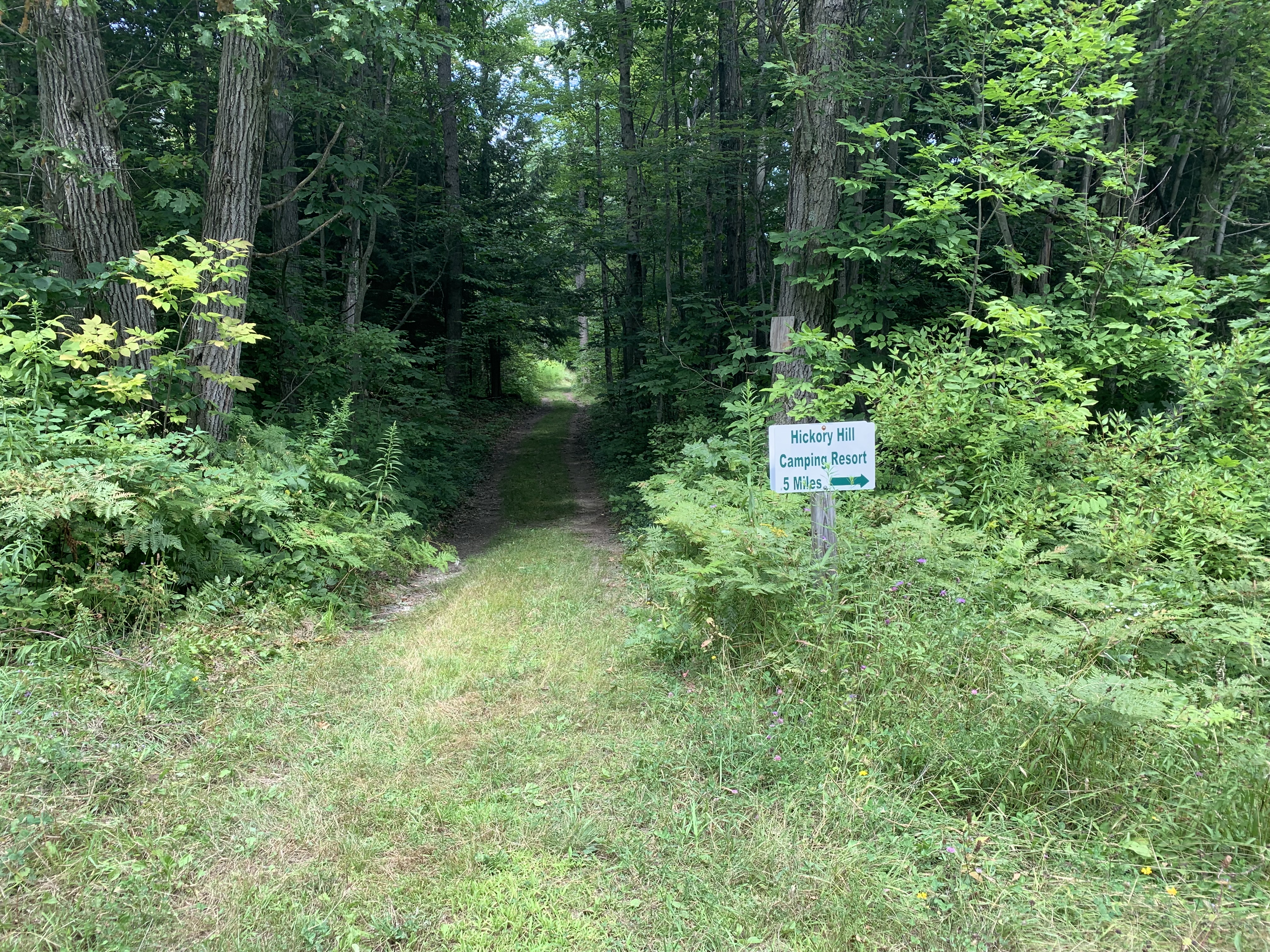
It’s very easy to see the start of the side trail down to Hickory Hill Campground.
The Naturalists will start with the Tourists. Following the social, they will continue for 0.2 miles and then will turn right onto a blue blazed trail to follow a pipeline down 0.7 miles to Hickory Hill Campground where they will find a car to return to the start point. (Total 2.2 miles).
Social. On this hike, we will take advantage of a Leanto and hold our social on the trail. Please bring a sandwich and extra water for yourself. You may also want to carry in some vegetables, chips, fruit or cookies to share – don’t go overboard – you do need to carry your snack in.
Directions:
From Springwater: Take NY-15 south through Wayland to I-390. Turn left to enter I-390 south. In 16 miles, merge onto I-86 East. Take the next exit (Exit 37) for NY-53 Kanona/Prattsburg. Turn right (S) on 53 for 0.6 miles. Turn left onto NY-415 for 1.4 miles. Turn left onto Spaulding Dr, the left onto Harrisburg Hollow Rd. In 0.4 miles turn right onto Sandpit Rd. There is plenty of roadside parking.
 From Naples: There are two routes, either through Cohocton to I-390 or follow NY-53 south: Head south on Main St in Naples. Just past the Wayside Market, stay straight onto NY-53 for 22.3 miles. After passing under I-86, turn left onto NY-415 for 1.4 miles. Turn left onto Spaulding Dr, the left onto Harrisburg Hollow Rd. In 0.4 miles turn right onto Sandpit Rd. There is plenty of roadside parking.
From Corning: Take I-86 west to Exit 38 NY-54 Bath/Hammondsport. Turn right onto NY-54 N, then left onto NY-415N for 1 mile. Turn right onto Spaulding Dr, the right onto Harrisburg Hollow Rd. In 0.4 miles turn right onto Sandpit Rd. There is plenty of roadside parking.
Car Pool from Access 1 to Access 2:Head southeast on Sandpit Rd. At the tee turn right onto Snyder Hill Rd. Continue onto Maple Heights and on down to the stop light at Washington St. At the next light, turn left onto Liberty St. Stay left onto Haverling St toward CR 13. In 2 miles, leave a Naturalist car near the Hickory Hill Campground. Continue north on Mitchellsville Rd for 1.3 miles. Turn left onto Robbins Rd (basically the first left turn). The road makes a right hand turn at the Bath/Wheeler town line.Make a U turn and park on the side of the road. at the start of the trail. The trail is a continuation of Robbins Rd that you came up on.
Looking for brochure.or mailing list so I can receive it in the mail.
Nothing opens up for mailing list.
There’s all kinds of very bizarre ads and post for viagra and other drugs above on calender page.
Please let me know if there’s a brochure available