
7405 Dryer Road
Victor
NY
CHANGE OF VENUE FROM THE EARLIER PUBLISHED HIKE: This Sunday we will be hiking in and around Ganondagan State Historic Site in Victor, with initial meeting and a pot-luck social at nearby Dryer Road Park. The three groups will have hikes ranging from 2 to 5.2 miles, all including the Grainary section of Ganondagan and its overlooks to the south toward the Bristol Hills. Trails are generally well maintained and gentle in slope, with a few uphill sections. Bring bug spray, wear long pants for tick control, and bring poles if you are used to hiking with them.
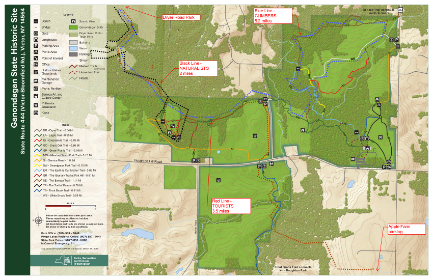 Ganondagan is the site of a large 17th century Seneca town, and offers hiking trails with interpretive markers illustrating the history and traditions of the Seneca people. The trails will take us through wooded rolling hills and meadows just south of the Village of Victor. Highlights will include the Granary Trail, where the Senecas protected and distributed their corn supplies on a palisaded mesa, and part of the Earth is Our Mother Trail, where interpretive markers describe local plants and their particular roles in Seneca life. Portions of the hikes will be in the Town of Victor’s Dryer Road Park, adjacent to the Fort Hill (Granary) portion of Ganondagan, and one hike will include a beautiful section of Victor Hiking Trails’ Seneca Trail, adjacent to Great Brook and its Beaver Pond.
All hikers meet at 3:45 at Dryer Road Park, 7405 Dryer Road, about 1 mile west of Route 444 and Dryer Road or 1.5 miles east of Malone Road in the Village of Victor. From there, Climbers and Naturalists will follow the Victor Hiking Trails pathway up the hill, past an open clearing and through a mature hardwood forest. Mountain bikers will know this area for its dense pattern of bike trails off to the sides of the main walking path. The trail leads to the open mesa at Fort Hill, where the circular Granary Trail offers expansive views as far as Bare Hill, and where interpretive markers describe Seneca life and history, their use of the protected mesa, and the conquest and destruction of Ganondagan during the 1687 Denonville Raid. Naturalists will circle the Grainary Trail and the open clearing and return to Dryer Road Park for a total hike of about 2 miles.
From the Granary Trail, Climbers will head east down the Eagle Trail, through more beautiful hardwood forest and across School Street to the Ganondagan village site and surrounding woods and fields. This group will explore the Seneca Trail and Grasslands Trail, looping through the hardwood forest and then an open meadow, returning to the Grainary area and Dryer Road Park for a total hike of about 5.2 miles.
Tourists will leave their dish to pass in someone else’s car at Dryer Road, then drive/car pool to the Apple Farm at 1640 Route 444, Victor. Park near the retail store to the rear of the main house. We will then hike west through the back lands of the Apple Farm to the Seneca Trail and head north along Great Brook to Boughton Hill Road. Crossing the road to the Ganondagan lands, we will head north next to School Street and turn west into the woods and up the hill to the Grainary Trail and the scenic overlook to the south. After looping around the Grainary, we will re-enter the woods into Dryer Road Park and back to the cars. Tourists will be driven to retrieve their cars at the Apple Farm at the conclusion of the social.
Please join us for a dish-to-pass social (optional) at the picnic pavilion at Dryer Road Park. Bring something delicious and nutritious, or make a contribution to our refreshments fund. BYO beverage.
Directions:
From Springwater/Honeoye area: Go north to Honeoye and then east on 20A to Route 64. Go north on 64 for 3.7 miles to the 5 and 20 intersection. Go west on 5 and 20 for 1.25 miles and make a right on Route 444 (Maple Ave.). Proceed 6.2 miles to Dryer Road (bottom of the hill, past the flashing light). Turn left at Dryer Road and go 1.4 miles to the entrance to Dryer Road Park, on your left. If you come to Malone Road, you have gone too far.
From points east: Take 5 and 20 west toward Bloomfield. Go right at the Route 444 intersection, and proceed 6.2 miles north to make a left on Dryer Road. Go 1.4 miles to the entrance to Dryer Road Park, on your left. If you come to Malone Road, you have gone too far.
From Rochester: Take Route 64 South from Pittsford to Mendon, and go east on Route 251 at the town center. In 1.5 miles make a right on Strong Road and then in 1.5 miles a left on Dryer Road. Dryer Road Park will be on the right in 1.6 miles.
Thanks for a lovely hike Saralinda! So many trails to choose from here. We walked through mature hardwoods, fields surrounded by beautiful varieties of wildflowers, and a stream with small waterfall cascades. We even saw a doe suckling her fawn in an old quarry on the return trip.
The historical markers were numerous and very interesting. Doug was a great naturalist instructor and even showed us the nearby Hopper Hill with an elevation of over 1000′. John L was a real trooper in spite of having to wield his hankie due to a runny nose. And his camera was ever ready for great photo ops! We had 2 Janes but sadly, Tarzan didn’t show up. Although mountain bikers were encountered on a few trails, they were all very considerate.
Three naturalists showed up and the remainder of the group did a combined Climber-Tourist hike of about 3.5 miles. The social had a truly gorgeous centerpiece of flowers from Katherine, and the food was, as usual, more than adequate for hungry hikers.