
Fairport
NY 14450
USA
————————- Change of Plans – We will meet at the trail head on the south side of the canal. See below ———
The Crescent Trail in Perinton, NY, is approximately 35 miles of footpaths starting in Bushnell’s Basin on the Erie Canal, and currently ending at Northside School in northern Perinton. Planned, developed and maintained by the Crescent Trail Association, this trail is built on state, town and private lands and connects with the Canalway trail and the Trolley trail, two multiuse trails in the town.
NOTE: Our original plans for this hike were at Indian Hill. However, ice on the trail and in the parking lot, made this hike best postponed until the trillium are out this spring. This Sunday hike has been moved to a flatter location that should not be as dangerous with ice. However, traction devices or snowshoes are highly recommended – bring extras if you would like to loan them to poorly prepared hikers.
NOTE 2: Snow is expected. Check the weather and dress accordingly. Remember to drive safely.
This Sunday we will hike a portion of the Crescent Trail along the Erie Canal and the White Brook Nature Area. We will meet at the trail head parking lot south of the canal off of Lyndon Rd. (The baseball parking lot was not plowed on Saturday, so we will avoid that.)
Three hike options will be available. All hikes will follow the road across the railroad tracks and the canal to the south side of the canal and the trail head on the east side of the road (about 2000 ft). The climbers will follow the orange trail to the northern part of the White Brook Nature Area, where we will leave the orange to follow the blue trail around the field and back to the orange and home, for a total of about 4 miles.
The tourists will follow start on the orange trail but will take the second turn left on the yellow trail, crossing White Brook and heading east along the canal. The trail ends at the Perinton town line, and returns along a blue trail at the canal’s edge. As the tourists approach the Lyndon bridge, they will have the option to continue along the canal toward Fairport, or to turn south back to the trail head, then across the canal to the ramp to the Canalway on the north side of the canal. The tourist hike leader should check a watch and plan a turn-around time on the canal path to return to the cars at 4.
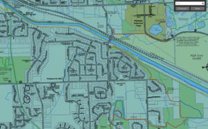
Canal and White Brook trail map. Click for full Crescent Trail map
The Naturalists will take the first left from the orange trail onto the yellow trail to head west the canal on a trail between the White Brook and the Canal. In about 1.5 miles, they will leave the canal, on a short climb to the trolley path, cross the canal on the footbridge and walk back to the cars on the Canalway on the north side of the canal for a total of about 3 miles.
If the weather permits, skiers will follow the climbers trail into White Brook.
Traction devices (spikes or spring coils) or snowshoes are highly recommended for all hikers. A nice layer of snow provides reasonable traction, but underneath is ice, making for slippery conditions at times.
Following the hike, Noonan’s on Rt 31 will be open for a brew and refreshments.
Directions to the Trail Head.
From Turk Hill Rd and Rt 31 in Perinton: Head north on Turk Hill Rd. Turn right onto Ayrault Rd at the next light. In 1.5 miles, at the bottom of a steep hill, turn left onto Lyndon Rd. Just before the bridge over the canal, the parking area is on the right.
From Springwater: From the flashing light, head north on Rt 15A for 2.7. miles. Bear right onto Old Bald Hill Rd S, then an immediate right onto Johnson Hill Rd. Continue on Johnson Hill Rd to the end. Turn left onto Co Rd 37. Stay on CR 37 for 11 miles (there is a left turn in Canadice to stay on CR 37) past Honeoye. Turn right onto Richmond Mills Rd and then left at the 1st cross street onto CR 40. After crossing 5 & 20, turn right onto Main St in Bloomfield. At the light turn left onto NY 444 for 5.7 miles into Victor. Turn right onto Main St (NY 96) then left on Church St. Continue north for 6 miles. past Lollypop Farm. Turn right onto NY 31, then left onto Aldrich Rd. The road turns left to become Ayrault Rd. In half a mile, turn right onto Lyndon Rd. Just before the bridge over the canal, the parking area is on the right.
From Rochester: Take I-490 E to exit 26, NY-31. Turn east on NY-31. In 0.4 miles, at the light, turn left onto Ayrault Rd. You will pass the Middle School and the High School before going down a steep hill. At the bottom (3.8 mi from Rt 31), turn left onto Lyndon Rd. Just before the bridge over the canal, the parking area is on the right.
From Naples: Take NY 21 north from Naples to South Bristol. Continue straight onto NY 64. In 13 miles at the light, turn left onto 5 & 20 west. In 6.8 miles turn right onto NY 444N to Victor. Turn right onto Main St (NY 96) then left on Church St. Continue north for 6 miles. past Lollypop Farm. Turn right onto NY 31, then left onto Aldrich Rd. The road turns left to become Ayrault Rd. In half a mile, turn right onto Lyndon Rd. Just before the bridge over the canal, the parking area is on the right.
From Canandaigua: Take NY 332 north to a left onto NY 96 N. At the traffic circle near Victor, take the first exit onto Lynaugh Rd. In 1 mile turn right onto Victor Egypt Rd. Continue north for 5 miles. past Lollypop Farm. Turn right onto NY 31, then left onto Aldrich Rd. The road turns left to become Ayrault Rd. In half a mile, turn right onto Lyndon Rd. Just before the bridge over the canal, the parking area is on the right.
From Geneseo: Take I-390 north to Rochester. Take exit 15 onto I-590 N. Take exit 5 onto I-490 E toward Victor and follow the directions from Rochester.
Directions to Noonan’s: Head south on Lyndon Rd. At the stop sign, turn right on Ayrault Rd. Take the first left at the top of the hill onto Mason Rd. At the light, turn right onto NY 31 W. Noonan’s is a white building on the right. Park behind the restaurant.