Springwater, NY
USA
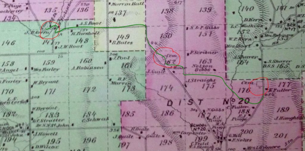
On Sunday, we are hiking between three cemeteries in Springwater, including the Green Gull Cemetery and the Pleasant Valley East Cemetery. In between, we will visit a surprise cemetery tucked into the hills of Springwater. All three cemeteries are noted on the 1872 Atlas of Livingston County. Click on the detailed map below to see the complete map of Springwater. The complete Atlas of Livingston County, New York, published by F. W. Beers & Co in 1872, is available on-line.
We will meet at 8664 Schribner Rd and carpool to the first cemetery.
Following the hike, join us for a pot luck social on Schribner Rd. Bring a dish to pass and your own beverage, or make a small $5 donation to the social fund.
Three hikes are planned. The Naturalists will carpool about 2 miles west to Green Gull Cemetery on Canadice Rd near Strutt St. This is a small cemetery above the road with graves of two veterans of the Revolutionary War. After exploring the cemetery, the Naturalists will follow Canadice Rd to Strutt St and climb Fox Rd to the top (about a 400 foot climb. From there we will follow the old Gilles Rd as laid out on the 1872 map to the second cemetery. From there we will follow trails through the woods and back to the starting point. This will be a 2 mile hike with both a climb up and down.
The Climbers and Tourists will carpool east to the Pleasant Valley Cemetery (East) on Tabors Corners Rd. This cemetery is also known as the East Springwater or The Fair View Cemetery and it contains graves of one War of 1812 veteran and 19 Civil War veterans. After exploring the cemetery, we will follow a farmer’s road across the Cohocton Creek, and up a steep climb to the fields above the Schribner Valley. The trail crosses Schribner and continues up along Giles Rd to our second cemetery. From there the Climbers will continue down Fox Rd to the Green Gull Cemetery. As they pass the Naturalists going the other direction, they will collect keys to the Naturalists cars to return to the start point. The Tourists will turn around at the second cemetery and follow the same route as the Naturalists back to the start point and the Social. A driver will be available to take drivers back to the Tabors Corners cemetery to pick up cars.
A note about the weather: The forecast calls for temperatures in the 40s and showers between 2 and 6 on Sunday. So dress warmly and bring a raincoat or poncho. Lets hope the forecast is off by a few hours.
Directions to the meeting place are available here. Directions for the hikes and the carpools will be available the day of the hike.

Appreciative of the themed hike, and the interwoven history within the hike (and too the Hike Announcement) of this Bicentennial Series Hike. Thanks for the detailed forethought and planning.