
Bath, NY 14810
USA
This Sunday hike is the first in a series. Over the next year we are planning to hike the entire Bristol Hills Branch I(BHB) of the Finger Lakes Trail (FLT). On the third Sunday of each month, we will hike a different section of the trail. The Climbers will do the longest hikes, completing the entire trail including all road walks. The Tourists will generally skip the road walks, making their hikes a bit shorter. And finally, the Naturalists will hike a selected portion of the trail, based on length and terrain. These hikes will be one way hikes, so expect some shuttling of cars.
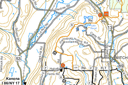 Our first BHB hike is on the Finger Lakes Trail map B3 (see the images). We will meet on Clark Hill Rd at the corner with LaRue Rd in Bath, NY. From there, some cars will drive to the north end of the hike on Mitchellsville Rd, the rest will drive to the south end of the hike at the corner of Ferris Rd and Harrisburg Hollow Rd.
The Climbers will car pool to the north end of the hike at Access Pt 18 on Mitchellsville Rd and will hike south. The hike will start with a long steep uphill, along a ravine. Once Lake David is reached, the trail flattens out, to a shallow, but steady climb to Harrisburg Hollow Rd. Crossing Harrisburg Hollow Rd, the hike will continue to the point where the BHB ends at the Finger Lakes Trail. Turning right, the climbers will follow the FLT west along the abandoned portion of Ferris Rd. When the FLT turns into the woods, we will continue on Ferris Rd back to the Tourists and Naturalists cars.
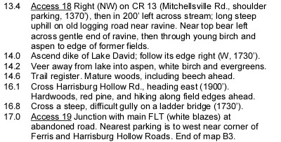 The Tourists and Naturalists will car pool to the south end of the hike. They will turn onto Harrisburg Hollow Rd and park the cars. The Naturalists and tourists will hike along Harrisburg Hollow Rd continuing north. In about half a mile, the Bristol Hills Branch will cross the road. The Tourists will turn left and follow the trail north (downhill) to Access 18 on Mitchellsville Rd where we hope to find the climbers cars and return by car to the southern start point. The Naturalists will turn right and follow the trail to the abandoned Ferris Rd. Turning right, they will follow the FLT and Ferris Rd to the top of the hill, and continue to the cars at Harrisburg Hollow. This trail passes through both forest and open fields. On the last leg of the BHB, you will cross a gully on a ladder bridge – a clever solution to a difficult crossing. If the Naturalists reach the FLT before 5:15, they may want to explore the FLT to the east, before returning to the cars.
We will do a picnic social after the hike on Harrisburg Hollow Rd and enjoy a beautiful view to the west. Bring a dish to pass and your own beverage (or contribute to the social fund). If it is raining, we will make other arrangements.
Directions:
From Springwater (and Wayland): Head south on NY-15 through Wayland. Turn left to get on I390. [If the entrance to I390 is still closed for construction, turn left on NY-415 just before going under I390. In 6.2 miles, turn righ onto Cohocton Look Lake Rd and in a half mile, turn left onto I-390S]. Continue onto I-86 (NY-17) east. Take Exit 37 and turn left only NY-53 north. In 2.8 miles, turn right onto Larue Rd, Take the first right onto Clark Hill Rd. We will meet here.
From Rochester and Dansville: Head south on I390 and join I-86 East. Take Exit 37 and follow the directions from Springwater.
From Bath and south: Head west on I-86. Take Exit 37 and follow the directions from Springwater.
From Naples and north: From NY-21 on the south edge of Naples, follow NY-53 South for 19 miles. Turn left onto Larue Rd. Take the first right onto Clark Hill Rd. We will meet here.
To get from the meeting location to Mitchellsville Rd: Turn right (North) onto Larue Rd for 2.2 miles. (Larue becomes Garner Rd in 1.3 miles) At the T, turn right onto CR 13 (Mitchellsville Rd. In 1.1 miles, the trail will be on the right. Best parking is on the right.
To get from the meeting location to Harrisburg Hollow Rd at Ferris Rd: Continue on Clark Hill Rd for 1.3 miles. Continue straight through the 4-way intersection. At the next intersection, turn left onto Harrisburg Hollow Rd. Park right there. (If you had continued straight, that would be Ferris Rd which becomes the FLT.) Warning: most of this route is dirt road.
To get from the North end back to the South end: As you come out of the trail to the cars, you will want to drive to the left on Mitchellsville Rd. Head north on Mitchellsville for 1.1 miles. Turn left onto Garner Rd. When Garner Rd turns right, continue straight onto LaRue Rd for 1.3 miles. Turn left onto Clark Hill Rd for 1.3 miles. Continue straight through the 4-way intersection. At the next intersection, turn left onto Harrisburg Hollow Rd. The Tourist cars should be there.
[ngg_images source=”galleries” container_ids=”15″ display_type=”photocrati-nextgen_basic_imagebrowser” ajax_pagination=”0″ order_by=”sortorder” order_direction=”ASC” returns=”included” maximum_entity_count=”500″]
If you have pictures of this section of the Bristol Hills Branch, please add them to our gallery. [ngg_uploader id=15]
Great concept to hike the BHB-FLT in entirety, spaced out over many months. Three great photos/images included in this hike announcement, picture #1 lends the presence of “being there”. Ohhhh, how I wish I could make it to this first hike in the series! Consider me there in spirit.