
Hikes led by Springwater Trails are generally held on Sunday afternoons and appear in this calendar in green.
| Sun | Mon | Tue | Wed | Thu | Fri | Sat |
|---|---|---|---|---|---|---|
| Wesley Hill Preserve, from Wesley Road: 42.72766,-77.4848 2:00 pm Wesley Hill Preserve, from Wesley Road: 42.72766,-77.4848 May 5 @ 2:00 pm – 4:00 pm This Sunday we will return to an old SWT favorite – the Finger Lakes Land Trust’s Wesley Hill Nature Preserve. Wesley Hill is a Finger Lakes Land Trust property of 390 acres including stands of northern hardwoods, red and white … Continue reading | ||||||
| Mother’s Day Hiking, Biking and/or Bird Watching Among the Virginia Bluebells at Mertensia Park 2:00 pm Mother’s Day Hiking, Biking and/or Bird Watching Among the Virginia Bluebells at Mertensia Park May 12 @ 2:00 pm – 4:00 pm 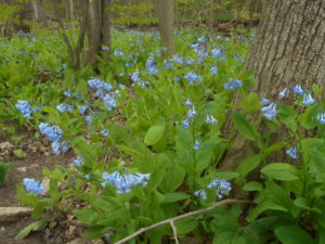 UPDATE: Since the forecast for Sunday afternoon is cool and rainy, the after-hike dish-to-pass social will be at Gene and Georgia’s townhouse in Collett Woods, only a few miles north of Mertensia Park. See directions below. Hiking and birding will … Continue reading | Celebrate The 20th Anniversary Of Wesley Hill Becoming A Nature Preserve! 11:00 am Celebrate The 20th Anniversary Of Wesley Hill Becoming A Nature Preserve! May 18 @ 11:00 am – 2:30 pm 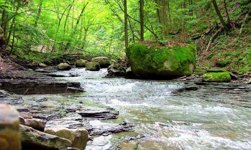 Spring is here!, and it is time to get outside. The Finger Lakes Land Trust is sponsoring a volunteer opportunity at Wesley Hill. This is an opportunity for Springwater Trails to say thank you to one of our popular hike … Continue reading | |||||
| FLT Letchworth Branch Series 2:00 pm FLT Letchworth Branch Series May 19 @ 2:00 pm – 4:00 pm  Last August, Springwater Trails started our Letchworth series. This series, which occurred once a month (usually the 3rd Sunday of the month), had to goal of hiking the entire Letchworth Branch in 2 hours segments. We have done the following … Continue reading | ||||||
| Trail Maintenance on The Bristol Hills Branch – Seman Road to Mt. Pleasant Street in Naples 4:00 pm Trail Maintenance on The Bristol Hills Branch – Seman Road to Mt. Pleasant Street in Naples May 26 @ 4:00 pm – 6:00 pm  The hike on Sunday 26th May2019 will follow a section of the Bristol Hills Branch of the Finger Lakes Trail in Naples. Springwater Trails has signed up to maintain this section of the Finger Lakes Trail. This section passes through … Continue reading |
Spring is here!, and it is time to get outside. The Finger Lakes Land Trust is sponsoring a volunteer opportunity at Wesley Hill. This is an opportunity for Springwater Trails to say thank you to one of our popular hike locations.
Wesley Hill is one of FLLT’s most iconic nature preserves, and on Monday, May 20th, it will be turning 20 years old! If you have never visited our westernmost preserve, this is your chance! Wesley Hill is full of beautiful vistas, gorges, and old growth trees.
Please join me on Saturday the 18th to help refresh the hiking trails and clear a short reroute, as well as conduct habitat management. At the end of the day, we will raise a glass of something bubbly to a magnificent place that is protected forever. Tools, work gloves, and refreshments (including N/A options), will be provided. We will meet at 11:00am at the WESLEY RD. parking area. Directions can be found here.
Original email from:
Jason Gorman, Nature Preserve Manager
Finger Lakes Land Trust
202 E. Court Street
Ithaca, NY 14850
607.275.9487
www.fllt.org
 Last August, Springwater Trails started our Letchworth series. This series, which occurred once a month (usually the 3rd Sunday of the month), had to goal of hiking the entire Letchworth Branch in 2 hours segments. We have done the following hikes:
August – Mt Morris (Access A) to the Dam Visitor Center (Access B)
October – Access D to Hogsback overlook (Access C) – time constraints meant we missed continuing to the Dam Visitor Center (Access B).
November-Access D to Access E.
December – Access F to the river.
January and February – Canceled.
March – Dygert Rd (Access H) to Oakland Rd (Access G).
April – The parade grounds (Access K) to Dygert Rd (Access H).
So what is left.
Access B to Access C – This short section is left as a personal exercise, next time you are in the area.
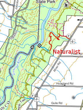
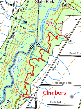 Access E to F. – This is a long hike which we are planning for this Sunday when a 2:00 start and an 8:30 sunset means we will have time to complete the hike.
Access F to G – Next month’s hike. (Remember, June hikes will start at 4:00)
Access K to L – This section from the Parade Grounds to where the trail returns to the road NY-436. north of Portageville, is currently a road walk. We will come back to this hike when the regular trail is reopened in the future.
Access L to the main FLT trail (Access N) – This 2.4 mile section follows the river bed along the old rail bed, and is mostly flat. We plan to complete this section in July.
All hikers will meet at 1:50 at Access Pt F on River Rd near the intersection of Picket Line Rd. We will then carpool back north to Access E in the Tourist and Naturalists cars. If you are running late, please meet us at Access E between Ridge Rd and Frost Rd. The hikes will take almost 3 hours, returning to the cars at about 5:00.
The Climbers will follow the blue access trail from the road (Access E) for 0.4 miles and turn left onto the main yellow trail. Continue on the main trail for 5.3 miles to a blue access trail going to the left. Access F and our cars are 0.3 miles up the access trail. This trail crosses many stream, some of which have steep sides. With all of the rain, we expect water is all streams, so be careful crossing each one. Total hike is 6 miles.
 The Tourists will do an out and back hike of 4.6 miles to an overlook of the river and gorge. You may want to carry binoculars and check out the birds and other wildlife in the gorge. Like the Climbers, the Tourists will follow the blue access trail from Access E. Turn left onto the main trail. In a mile and a half, turn right on a blue side trail leading to the overlook (0.4 miles). After taking your time with the view, follow the blue trail back. Turn left onto the main trail. Its 1.5 miles back to a right turn onto the access trail, then back to the cars.
The Naturalists will follow the Tourists to the overlook turnoff. At the turnoff, the Naturalists will turn around, and return to the cars. This hike will be 3.8 miles (since it is an out and back hike, the Naturalists hike leader has the option to turn around earlier).
 Following the hike, please join us for Pizza at the Nunda Pizza Corner on NY 408 and East St in Nunda.
Directions
From Springwater: From the light at the 4 corners, go west to follow NY 15 N for 1.5 miles to the top of the hill. Turn left onto Liberty Pole Rd (CR 38) and continue straight for 8.1 miles to Groveland. Turn left on NY-63 S and then a quick right (0.3 miles) onto NY-258 across the flats. In 1.9 miles, turn right onto NY-36 N. Pass the Correctional Facility and turn left (in 3.1 miles) on Dutch Street Rd (CR 30). Turn left to stay on Dutch Street Rd when Cleveland Rd enters from the right. Take the next right onto Ridge Rd for 3.5 miles. Turn left onto River Rd. In about half a mile, you will pass Access E on the right. Continue for 2.3 more miles past Frost Rd, Hoagland Rd, and Picket Rd. Parking for Access Point F will be on the shoulder.
From Wayland and Naples: Follow NY-21S to Wayland. Turn left (South) on NY-21 at the light in Wayland. In 1.8 miles, turn right onto I-390N through Dansville, Use exit 6 and turn left onto NY-36 N for 2.3 miles past the Correctional Facility. Turn left onto Dutch Street Rd and follow the Springwater directions above.
From Geneseo: Take South St west until it turns left and becomes Mt Morris Rd. In 2.0 miles, continue straight onto NY-63S. In 2.2 miles, the road curves to the right and becomes NY-48S. (63 turns left). Continue on NY-408S into Mt Morris. Turn left on Main St, then immediately right on Chapel st, to stay on NY-408, In 2.5 miles, turn a slight right onto River Rd. You will pass Access E on the right in 2.5 miles. Continue for anothe 2.3 miles to Access F and shoulder parking.
From Rochester: Take I390 south to exit 7. Turn left onto NY-408S and follow the Geneseo directions above.
Direction to the Nunda Pizza Corner: Head south on River Rd. Take the first left out to NY-408. Turn south on 408 into Nunda. The pizza will be on the left.
The hike on Sunday 26th May2019 will follow a section of the Bristol Hills Branch of the Finger Lakes Trail in Naples. Springwater Trails has signed up to maintain this section of the Finger Lakes Trail. This section passes through the West Hill Preserve off Seman Rd and then across private land to Mt Pleasant St. in Naples.
We will walk this stretch of the BHB and cut away and brush and weeds that have overgrown the trail. The most useful tools for this are lopers and a small saw, and a weed whacker or two for the long grass; be sure to wear good work or gardening gloves. It’s a fairly long hike; if there’s a lot of grass to be cleared (this is usually at the two ends of the trail) then we’ll either leave teams there with weed whackers to concentrate on that or come back another day to finish the job.
We will meet at the entrance to the West Hill Preserve on Seman Road (42.66166, -77.396288). We will shuttle some cars down to the hike end in Naples (42.625950, -77.397304) before we start. The climbers will follow the trail down to the old cemetery in Naples. Naturalists follow the trail to the sign in box and then return to the cars on Seman Road.
Please note: Dogs are not allowed to hike on the Nature Conservancy property.
The Social
Following the hike, please join us for a social at the Neapolitan Pizzeria at 120 N. Main Street in Naples. If the weather is fine we can take a table on the porch.
Directions to the Hike Meeting Point:
From Springwater: Head south on NY 15 (for 5.2mi). At the light in Wayland turn left on NY 21N (for 6.7mi). In N Cohocton, turn left to stay on NY 21N (for 4.5mi). In Naples, turn left again to stay on NY 21N (for 1.8mi). On the north side of Naples, turn left on CR12 and head up the hill for 1.9 miles. Take the first left, Rhine St., to the 4 way intersection. Go left onto Seman Rd. Trailhead is about 1/2 mile, by a big sign on the left. Park along the road.
From Honeoye: Head south on CR 36 on the west side of Honeoye Lake (for 13.6 miles from NY 20A). Turn left onto Gulick Rd (for 2 mi), then right on Davis Rd (for 0.7mi). At the end of Davis, turn left on W Hollow Rd (CR 33) for 0.5mi, then right on Seman Rd. The Trailhead is about 1 mile, by a big sign on the right. Park along the road.
Italy Valley to Italy Hill MAP
Note as of June 1: This is a revised hike plan to avoid rough and boggy conditions at the top section of the trail. Meeting location and Social location remain the same.
Two winters ago we did this hike in the snow coming downhill. Now we can enjoy this gentle and beautiful incline up along the east side of the lovely Italy Valley in nicer weather. The trail is a section of the Bristol Hills Branch of the Finger Lakes Trail, rising from the valley floor to the “Outback Inn” shelter and beyond, crossing one substantial gully with waterfall and passing several minor ones. This will be an out-and-back hike with different lengths for the Tourists and Climbers, and with a flatter alternative trail hugging the base of the hill for the Naturalists. Bring poles if you use them regularly, waterproof boots and good leg protection, as the trail will be muddy in places and a section of narrow trail through tall grass as we cross the valley floor. Also bug spray.
NOTE: THIS HIKE STARTS AT 4 PM – SWT SUMMER HOURS.
Meet at 3:45 at the Italy Valley Road trail head, north of 1150 Italy Valley Road (42.626312, -77.281368). Park on either road shoulder near the white barn on the east side of the road; the old parking lot across the road is no longer in use. All groups will cross the valley from here and head into the woods. Naturalists will split off at the base of the hill for a hike of up to 1 mile north, returning the same way. Tourists will take the blazed FLT up the hill to the Outback Inn (about 2 miles) and then return. Climbers will continue past the Outback Inn to the gully and waterfall, then return for a total of about 5 miles.
Social: Please join us for the social at Carrie’s home at 4489 W. Sherman Hollow Road, Branchport – about 9 miles from the hike start/finish point.
Directions
From Springwater, Wayland and Dansville: Take NY-15 south to Wayland. Turn left at the light onto NY 21 N. In 6.7 miles turn left to stay on NY-21. At the stop sign in Naples, turn right on NY 53S. In 1.3 miles, turn left onto Italy Valley Rd. In 7.7 miles, past 1150 Italy Valley Road, park on the road shoulder near the trail head – the metal gates in a wood board fence on your right. There is a FLT marker sign.
From Honeoye: Take CR 36 (West Lake Rd) into Naples. Turn right on NY 21S and continue straight onto NY 53S. In 1.3 miles, turn left onto Italy Valley Rd. In 7.7 miles, past 1150 Italy Valley Road, park on the road shoulder near the trail head – the metal gates in a wood board fence on your right.
From Rochester, Canandaigua or points east: Take 5&20 to Reeds Corners (east of Canandaigua) and Route 247 through Rushville to Potter, where it joins with Route 364. Just past Potter, take the first right, on Friend Road. In about .5 miles, take a right on Italy Valley Road. Go south on Italy Valley Road about 6.5 miles to the trail head on your left – the metal gates in front of a white barn, with a Finger Lakes Trail marker sign.
Directions to social
From lower parking area: Go north on Italy Valley Road 6.5 miles to the intersection with Friend Road. Make a right on Friend Road, then take the first right on Bordwell Road. Go 1.8 miles. When Bordwell Road ends, your destination will be straight ahead of you at 4489 W. Sherman Hollow Rd. Find a safe piece of road shoulder for parking at 4489 W. Sherman Hollow.
This Sunday we will hike the Middlesex Valley Rail Trail, which runs northeast from Naples, passing through the lowlands of the Hi Tor Wildlife Management Area. The 7.2 mile rail trail is parallel to Route 245, and follows alongside of sections of the West River. We will hike on the section between Parrish Road and Cayward Cross Road, placing cars at several different parking areas along the way to allow for several distances of hiking. The trail is level and wide and slightly downhill, easy walking, though poles will be helpful for any muddy areas.The Middlesex Valley Railroad began service in 1892 between Naples and Stanley, with connections to Geneva, Canandaigua and Wayne County. In 1895 it became part of the Lehigh Valley Railroad system, and continued in service until 1970. Now part of the State-owned Hi Tor area, most of the trail is a raised path with wetlands on either side – some shrubby and some forested. Along the way are waterfowl nesting boxes, and about a mile from the north end is a heron rookery. Wendy has told us that there are limited babies this year possibly due to eagles. Hopefully we will see some wildlife.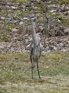
We will meet at 4 PM at the parking lot on the north side of Parrish Road, which runs across the valley from Route 21 (near Monica’s Pies) to Route 245 (near the base of Conklin Gully). Will leave enough cars there to accommodate the return trip for all the Climbers. We will then leave enough cars to accommodate the Tourists at the Sunnyside parking lot, along the way to our hike starting point. Everyone will begin the hike heading south from the Cayward Cross Road parking area. PLEASE wear clothing appropriate for tall grass, bugs and mud. Bring bug spray and a water bottle.
Naturalists will hike down the trail as far as the rookery, then return to their cars, a total of 2 to 2.5 miles. Tourists will hike through the rookery and on to Sunnyside, a total distance of about 3 miles. The Climbers will hike past Sunnyside and on to Parrish Road, for a total distance of about 5.6 miles. The southernmost 1.2 miles of the trail, extending past Parrish Road to Naples, is currently closed due to a bridge outage.
Following the hike, please join us for an optional social at the Redwood Restaurant on Rt. 21S in Naples.
Map: See map here: MV Rail Trail map
Directions to the Hike Meeting Point:
From Springwater/Dansville/Wayland: Take Rt 21N into Naples. Turn left onto Main St for 1.5 miles. Turn right on Rt#245 (across from Bob and Ruth’s). Continue 1.5 miles, make a left on Parrish Rd. Parking area is on the right, in about .2 miles.
From Honeoye: Take Rt#36 south into Naples, left on Main St for approximately 1.25 miles. Right on Rt#245 (Across from Bob and Ruth’s). Continue 1.5 miles then left on Parrish Rd. Parking area is on the right, in about .2 miles.
From Canandaigua: Take Rt#21S to Woodville. Keep straight toward Naples. Turn left on Parrish Road about 1.5 miles past Woodville, just after you pass Monica’s Pies. The parking area will be on your left, in about .5 miles.
 Rain, Father’s Day, busy week – All adds up to canceling today’s hike. Sorry for the inconvenience:
Today’s Hike is Canceled! Join us next Sunday.
Happy Father’s Day. Please join Springwater Trails for a hike along the Genesee River. Bring your father or your grandson and enjoy the views. Because of Father’s Day, please leave a message if you are planning to hike with us. Please check the website the day of the hike – We will cancel at 1:00, if no one plans to hike. Thanks.
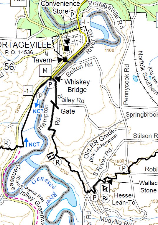
This week will mark the end of the Springwater Trails Letchworth Series and the start of a new series showing off the main Finger Lakes Trail between the Letchworth and Bristol Hills branches. Our Letchworth Series was plagued with weather and water, so we will be leaving Letchworth with a few sections undone. But it is time to move on.
This hike will start in the town of Portageville south of the Letchworth Park. We start on a portion of the trail which is shared with the Genesee Valley Greenway and will end on a section that is shared with the North Country Trail. We can dedicate this hike to continued cooperation between hikers and hiking groups.
All hikers will meet in Portageville south of the bridge on NY 436 across the Genesee River. NY 436 turns right in the center of Portageville but the trailhead is straight ahead about 100 feet up Main St (south of the Hotel).
The first section of the hike follows the old railroad bed, cutting across a loop in the river for a mile.The Naturalists will continue under the Whiskey Bridge and south along River Rd (a little used section of dirt road) to NY 19A, where they will take a sharp right turn onto the main Finger Lakes Trail and hike back to the Whiskey Bridge. After a short exploration of the bridge itself, the Naturalists will return to the west side of the Bridge and scramble down a steep connection to the right back to the branch trail. Turning left, they will retrace the branch trail to Portageville.
Meanwhile the Tourists and Climbers will leave Portageville on the branch trail. When they come to the Whiskey Bridge, they will turn right to climb up to the entrance to the bridge and the main trail. After crossing the river, the trail continues along dirt roads to a nice view of the river, for about 3 miles to a parking area on S River Rd, where we will have a car waiting to return to Portageville.
Following the hike, join us for a social at the Sunrise Restaurant in Dansville.
Directions:
From Springwater, Wayland and Dansville: Take 15 S to Wayland. Turn right and follow NY 63N to Dansville. Turn left on NY 36N (Ossian St). In half a mile, stay straight onto NY-436W (Ossian St). Continue through Nunda and past the entrance to Letchworth. At the bottom of the hill you will cross the Genesee River into Portageville. At the cross-street Hamilton St, (the Genesee Falls Inn is on the left), continue straight as 436 turns right. The Letchworth Branch Trail enters the woods on the left.
From Honeoye and Hemlock: Take NY 20A west through Livonia and Lakeville. Turn left onto the ramp for 390S. Take the next exit for NY 408S. Stay on 408 through Mt Morris into Nunda. Turn right at the light on NY 436W. Go past the entrance to Letchworth. At the bottom of the hill you will cross the Genesee River into Portageville. At the cross-street Hamilton St, (the Genesee Falls Inn is on the left), continue straight as 436 turns right. The Letchworth Branch Trail enters the woods on the left.
Directions to the Social: Follow 436E back through Nunda to Dansville. Continue straight onto NY-36. Turn left on Main St. The restaurant is on the right with parking on the street or in the rear.
For our June 23 event hike we will revisit Onanda Park, on the west shore of Canandaigua Lake (4965 County Road 16), for the summer solstice experience – hikes in the woods and in the streambed, with a West Lake Road cycling option and an optional side trip to the nearby Quiet Meadows wildlife and meditation sanctuary.
Meet at the parking lot on the west (Uplands) side of County Road 16 (a.k.a West Lake Road) at 3:45. We will divide into three groups: Cyclists, Naturalists/Meditators, and Wet Feet Hikers. Cyclists and Naturalists/Meditators may time their activities so that they get in some wet feet hiking during the second half of the event.
Cyclists will head north on West Lake Road for approximately 5.25 miles to the Yacht Club, then return, for a total of 10.5 miles, or choose a longer route if they wish. West Lake Road is a good cycling route, with paved shoulders averaging 4′ and a 35 MPH speed limit. There are two moderate climbs each way, but much of the route is at lake level. After returning to the starting point, Cyclists may cool off with a hike up the creekbed and back (bring a change of shoes).
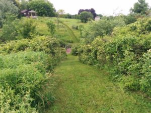
Naturalists/Meditators will car pool about 1.1 miles to The Quiet Meadows, at 5787 Barnes Road. The Quiet Meadows is a Certified Wildlife Habitat and a private outdoor sanctuary for meditation. It is not a recreation site, but is intended for quiet contemplation and appreciation of nature. The 5 acre property includes a grass labrynth and a network of mowed grass paths and bridges through shrubs, grasslands and wetlands. As the owners explain at their web site, “visitors are encouraged to walk the paths and the labrynth, sit on the benches for quiet repose, prayer and reflection and take away with you some of the stillness of the hills.” This is a particularly beautiful time of year in the meadows, with many wildflowers and flowering shrubs in bloom. You may want to revisit this site many times for its outstanding sense of peace. See https://www.quietmeadows.org/about.html for more about Quiet Meadows and the tradition of the labrynth. After the session at the Quiet Meadows, the Naturalists/Meditators will return to Onanda Park to cool down with a short hike up the creekbed (bring a change of shoes).
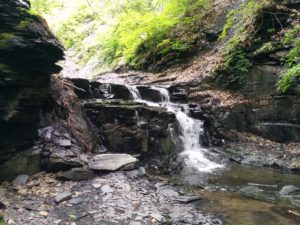
Climbers, a.k.a. Wet Feet Hikers, will explore a different section of Onanda Park from the trails we saw in the snow last March. We will start off on the South Rim Trail (about .75 miles), then head up the creekbed of Barnes Gully and back, passing through the culvert under West Lake Road and down to the mouth of the creek at the lake for some stone skipping. The creek hike is not a town-sanctioned trail, but walking in it is not prohibited, and there are well traveled paths along one side or the other across most of the length. Getting between them requires going through the stream, so expect to get your feet wet. Water sandals or old sneakers with good treads are recommended. The water level will be up to ankle height in most places. We will encounter a series of waterfalls of increasing difficulty, and will keep going until we reach the chicken-out point. Estimated creekbed hiking distance, including the trip to the lakeshore and back, is about 2.5 miles.
Social – Please join us for a dish-to-pass social in a lakeview pavilion close to the parking area.
Directions: from Springwater: Take Route 15 south to Wayland and Route 21 east/north to Naples. Continue through Naples and Woodville. 2.75 north of Woodville, take a right to follow Route 21 north where it splits with 64. Go another 4.9 miles, then make a right on County Road 16 (a.k.a West Lake Road). Enjoy the panoramic view of the lake. In 2 miles you will be down near the lake shore. Make a left into the “Uplands Trail Access” entrance to Onanda Park. Park in upper lot. This is free parking and access, unlike the lot on the lake side.
From Rochester and points north/west/east: Head to Routes 5 and 20 via Bloomfield or Canandaigua. About a mile west of the City of Canandaigua, turn south on Route NYS Route 21S. Go 4.3 miles, through the hamlet of Cheshire. At the south end of Cheshire, just over the hill, take a left on Deuel Road. In 2.2 miles, Deuel Road will end at County Rd 16 (West Lake Road). Make a right and go down the hill for .5 miles. The Onanda Park “Uplands Trail Access” entrance will be on your right. Park in upper lot. This is free parking and access, unlike the lot on the lake side.
This week we will have 4 groups. All will meet at the parking area near the North boat launch at 4:00. Paddlers are asked to arrive about 20 minutes early to have time to ready their boats for a 4:00 launch.
Paddlers will head south along the eastern shore from the launch for 2-3 miles, depending on the conditions and the speed of the paddlers. After 1 hour they will turn back to the launch along the western or eastern shore.
Hikers will be walking Rob’s Trail as follows
Naturalists will hike the lakeside trail for 1.75 miles or less, depending on time, before returning to the parking area by the boat launch. A hike leader is needed for this group.
Climbers will follow the lakeside trail, then connect to the white blazed trail which leads uphill to the trailhead on NY 15A. Length of hike 4.25 miles. This group will need a ride back to their vehicles at the boat launch. A hike leader is needed for this group.
Tourists, led by Jane,will drive up to the trailhead on NY 15A and hike down on the white blazed trail to connect with the lakeside trail back to the parking area by the boat launch. These folks will need a ride back up to their vehicles on 15A. Mileage is 4.25.
If hikers wish to arrange a key exchange this would facilitate the transportation.
After Hike Social
Since the Hemlock Grill is not open on Sundays, we will be picnicking at Hemlock Park on the North shore of Hemlock Lake, Rix Hill Rd.
Please bring something delicious and nutritious to share, or a make contribution to the social fund.
From NY15A south of Hemlock, NY: turn west onto Rix Hill Rd. then immediately left onto Boat Launch Rd. The launch and parking area are 1.1 miles south.
CHANGE OF VENUE FROM THE EARLIER PUBLISHED HIKE: This Sunday we will be hiking in and around Ganondagan State Historic Site in Victor, with initial meeting and a pot-luck social at nearby Dryer Road Park. The three groups will have hikes ranging from 2 to 5.2 miles, all including the Grainary section of Ganondagan and its overlooks to the south toward the Bristol Hills. Trails are generally well maintained and gentle in slope, with a few uphill sections. Bring bug spray, wear long pants for tick control, and bring poles if you are used to hiking with them.
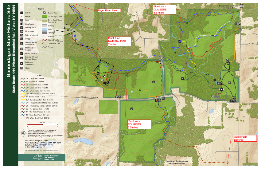 Ganondagan is the site of a large 17th century Seneca town, and offers hiking trails with interpretive markers illustrating the history and traditions of the Seneca people. The trails will take us through wooded rolling hills and meadows just south of the Village of Victor. Highlights will include the Granary Trail, where the Senecas protected and distributed their corn supplies on a palisaded mesa, and part of the Earth is Our Mother Trail, where interpretive markers describe local plants and their particular roles in Seneca life. Portions of the hikes will be in the Town of Victor’s Dryer Road Park, adjacent to the Fort Hill (Granary) portion of Ganondagan, and one hike will include a beautiful section of Victor Hiking Trails’ Seneca Trail, adjacent to Great Brook and its Beaver Pond.
All hikers meet at 3:45 at Dryer Road Park, 7405 Dryer Road, about 1 mile west of Route 444 and Dryer Road or 1.5 miles east of Malone Road in the Village of Victor. From there, Climbers and Naturalists will follow the Victor Hiking Trails pathway up the hill, past an open clearing and through a mature hardwood forest. Mountain bikers will know this area for its dense pattern of bike trails off to the sides of the main walking path. The trail leads to the open mesa at Fort Hill, where the circular Granary Trail offers expansive views as far as Bare Hill, and where interpretive markers describe Seneca life and history, their use of the protected mesa, and the conquest and destruction of Ganondagan during the 1687 Denonville Raid. Naturalists will circle the Grainary Trail and the open clearing and return to Dryer Road Park for a total hike of about 2 miles.
From the Granary Trail, Climbers will head east down the Eagle Trail, through more beautiful hardwood forest and across School Street to the Ganondagan village site and surrounding woods and fields. This group will explore the Seneca Trail and Grasslands Trail, looping through the hardwood forest and then an open meadow, returning to the Grainary area and Dryer Road Park for a total hike of about 5.2 miles.
Tourists will leave their dish to pass in someone else’s car at Dryer Road, then drive/car pool to the Apple Farm at 1640 Route 444, Victor. Park near the retail store to the rear of the main house. We will then hike west through the back lands of the Apple Farm to the Seneca Trail and head north along Great Brook to Boughton Hill Road. Crossing the road to the Ganondagan lands, we will head north next to School Street and turn west into the woods and up the hill to the Grainary Trail and the scenic overlook to the south. After looping around the Grainary, we will re-enter the woods into Dryer Road Park and back to the cars. Tourists will be driven to retrieve their cars at the Apple Farm at the conclusion of the social.
Please join us for a dish-to-pass social (optional) at the picnic pavilion at Dryer Road Park. Bring something delicious and nutritious, or make a contribution to our refreshments fund. BYO beverage.
Directions:
From Springwater/Honeoye area: Go north to Honeoye and then east on 20A to Route 64. Go north on 64 for 3.7 miles to the 5 and 20 intersection. Go west on 5 and 20 for 1.25 miles and make a right on Route 444 (Maple Ave.). Proceed 6.2 miles to Dryer Road (bottom of the hill, past the flashing light). Turn left at Dryer Road and go 1.4 miles to the entrance to Dryer Road Park, on your left. If you come to Malone Road, you have gone too far.
From points east: Take 5 and 20 west toward Bloomfield. Go right at the Route 444 intersection, and proceed 6.2 miles north to make a left on Dryer Road. Go 1.4 miles to the entrance to Dryer Road Park, on your left. If you come to Malone Road, you have gone too far.
From Rochester: Take Route 64 South from Pittsford to Mendon, and go east on Route 251 at the town center. In 1.5 miles make a right on Strong Road and then in 1.5 miles a left on Dryer Road. Dryer Road Park will be on the right in 1.6 miles.
Webinar: Tuesday July 16 2019 at 12:00 Noon
Speaker: Dr. Lori Spears, USU Assistant Professor
Date: Tuesday, July 16, 12:00 pm (MDT) – Please ignore the date in the title; it is an unavoidable posting date and NOT the date of the webinar!
The spotted lanternfly has been identified as a nasty invasive insect that is busy killing trees in Pennsylvania. The forestry and university authorities in PA have launched a series of webinars aimed at educating hikers such as ourselves in identifying and reporting these marauders. There’s is one coming up on 16th July; you are invited to join in from the comfort of your own home – we may be able to help limit this beast in New York.

Spotted lanternfly is an invasive planthopper that is native to parts of Asia and was first detected in the U.S. in Pennsylvania in 2014. Spotted lanternflies feed on a wide range of host plants, including grapes, fruit trees, hops, and hardwood ornamental trees. This presentation will cover the biology, identification, and possible control options for spotted lanternfly and other invasive landscape tree pests, such as emerald ash borer and Asian longhorned beetle.
Lori is the Cooperative Agricultural Pest Survey (CAPS) Program Coordinator at Utah State University. The CAPS Program is a federal program coordinated by the United States Department of Agriculture (USDA) Animal and Plant Health Inspection Service (APHIS) Plant Protection and Quarantine (PPQ), and whose goal is to protect U.S. agriculture from introductions of high risk invasive pests by conducting early detection surveys and providing outreach and education programs that support and enhance efforts to prevent new exotic pest entry and establishment. Her research and outreach programs have focused on the ecology and management of invasive insects and using bycatch from early detection surveys to learn more about beneficial insects, such as pollinators and lady beetles. Lori received a PhD in Ecology from Utah State University in 2012.
Co-sponsored by Utah State University Integrated Pest Management Group
|
|||||||||||||||
Looking for brochure.or mailing list so I can receive it in the mail.
Nothing opens up for mailing list.
There’s all kinds of very bizarre ads and post for viagra and other drugs above on calender page.
Please let me know if there’s a brochure available