
Hikes led by Springwater Trails are generally held on Sunday afternoons and appear in this calendar in green.
| Sun | Mon | Tue | Wed | Thu | Fri | Sat |
|---|---|---|---|---|---|---|
| Open House at the NEW Springwater Town Highway Barn 10:00 am Open House at the NEW Springwater Town Highway Barn @ Town of Springwater Highway Barn Nov 4 @ 10:00 am – 2:00 pm TOWN OF SPRINGWATER OPEN HOUSE For NEW TOWN HIGHWAY BARN 8319 Hudson Road, Springwater, NY November 4, 2017 10:00 am to 2:00 pm Fun for the whole family – food and beverages will be provided. Come on down and help … Continue reading | ||||||
| Wesley Hill 2:00 pm Wesley Hill @ Gulick Rd Parking Lot Nov 5 @ 2:00 pm – 4:00 pm This Sunday we will return to Wesley Hill Nature Preserve for a fall loop hike around the perimeter from the Gulick Road parking area, staying clear of the western sections where bow hunting is in progress. Wesley Hill is a … Continue reading Wesley Hill 2:00 pm Wesley Hill @ Gulick Rd Parking Lot Nov 5 @ 2:00 pm – 4:00 pm This Sunday we will return to Wesley Hill Nature Preserve for a fall loop hike around the perimeter from the Gulick Road parking area, staying clear of the western sections where bow hunting is in progress. Wesley Hill is a … Continue reading | ||||||
| Friends of Genesee Valley Greenway Friends of Genesee Valley Greenway @ Mount Morris VFW Nov 12 all-day 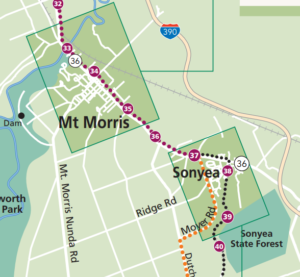 Springwater Trails (SWTs) will join the Friends of the Genesee Valley Greenway (FOGVG) for the events they have planned for their Hike, Bike, Program, Dinner and Annual Meeting. Below is the information posted on their website. SWTs is adding one … Continue reading | ||||||
| Bristol Hills Branch Hike #5 2:00 pm Bristol Hills Branch Hike #5 @ Italy Hill Nov 19 @ 2:00 pm – 4:00 pm 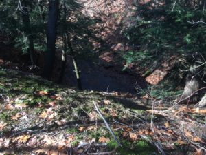 This Sunday, Springwater Trails will continue our monthly hike series on the Bristol Hills Branch of the Finger Lakes Trail.on the hills east of Italy Valley. Next month we will hike down from these hills to Italy valley but for … Continue reading | ||||||
| Hi Tor WMA 2:00 pm Hi Tor WMA @ High Tor WMA Nov 26 @ 2:00 pm – 4:00 pm  November 26th Post Pie Hike~ This Sunday we will hike the road along the West River at the south end of Canandaigua lake. Come work off that extra piece of pie and dollup of ice cream! This is a nice … Continue reading |
Description
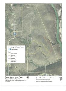
This preserve, maintained by the Finger Lakes Land Trust, is a perfect refuge during hunting season. In fact, our hikers will be performing a service to the land trust by patrolling the woods as they walk. Steege Hill is about 800 acres acquired in 2001 from an anonymous donor. The forest is regenerating after heavy logging in the 1970’s and contains many species of hardwoods. The 6 miles of trails are constructed largely on the old logging roads. On some of the steep slopes original hardwoods and conifers still remain. From its hilltop vantage point, there is a bird’s eye view of the Chemung River. Worth mentioning are two notable creatures that inhabit this woods. Timber Rattlesnakes have long been residents here, especially on the sunlit rocky outcroppings. They may be snugly out of sight this time of year. The nests of Allegheny Mound Ants are common sight, trailside and in clearings. Black bears like it here too.
Hike Groups
Lets hope the weather conditions are more favorable than last year’s wet and snowy visit to Steege Hill. All groups will depart together from the parking area, heading uphill for about 1/2 mile on a moderate pitch. There are 4 trail loops to explore.
Naturalists will cruise around the Yellow Loop, about a 2 mile jaunt with a few small inclines and a pond. A volunteer leader is needed for this group.
Tourists will traverse the blue and orange trails, enjoying a variety of terrain with some moderate climbs, about 3.5miles. A volunteer leader will also be needed for this group.
Climbers will tackle the white and red trails which offer some up and down hill changes as well as a nice valley view. Distance is about 4.5 miles.
Hopefully all groups will arrive back at the starting point at approximately the same time.
Parking space at Steege Hill is limited. Carpooling is highly recommended. Meet in Springwater at the Town Hall on Route 15 at 12:45 as the drive is about 1 hour.
Directions take 390 south to I 86. Take exit 48 then follow Rt 352E for 1.5 miles. Turn right on South Corning Rd. for .7 miles. After crossing bridge across Chemung River, turn left on Steege Hill Rd. Follow for 1 mile. Preserve is on left.
After Hike Social will be at Tags Restaurant, 3037 Rt 252 in Big Flats. It is a very short drive from the hike. Good food. We have been there previously.
 Our hike this Sunday will be at the Ganondagan State Historic Site, 7000 County Road 41 (Boughton Hill Road) in Victor. Ganondagan is the site of a large 17th century Seneca town, and offers hiking trails with interpretive markers illustrating the history and traditions of the Seneca people. The trails will take us through wooded rolling hills and meadows just south of the Village of Victor. Highlights will include the Granary Trail, where the Seneca protected and distributed their corn supplies on a palisaded mesa, and the Earth is Our Mother Trail, where interpretive markers describe local plants and their particular roles in Seneca life. The Seneca Art and Cultural Center (Interpretive Center) will be open for hikers to explore at the end if they wish, for a modest admission price. A portion of the hike will be in the Town of Victor’s Dryer Road Park, adjacent to the Fort Hill (Granary) portion of Ganondagan.

Marquis de Denonville
We will meet at 1:45 at the Interpretive Center parking lot, about .2 miles west of the intersection of Route 444 and Boughton Hill Road. Leaving some cars behind, Climbers and Tourists will car pool to Dryer Road Park and follow the Victor Hiking Trails pathway up the hill, past an open field and through a mature hardwood forest. Mountain bikers will know this area for its dense pattern of bike trails off to the sides of the main walking path. The trail leads to the open mesa at Fort Hill, where the circular Granary Trail offers expansive views as far as Bare Hill, and where interpretive markers describe Seneca life and history, their use of the protected mesa, and the conquest and destruction of Ganondagan during the 1687 Denonville Raid.
From the Granary Trail we will head east down the Eagle Trail, through more beautiful hardwood forest and across School Street to the Ganondagan village site and surrounding woods and fields. Climbers will explore the Seneca Trail and Grasslands Trail, through the hardwood forest and then an open meadow, returning to the Interpretive Center by the Earth is Our Mother Trail for a total hike of about 4 miles. Tourists will follow a similar but shorter route ending at Route 444 where cars will be driving back to the Interpretive Center, for a total of 3+ miles.
Naturalists may take one car to the School Street crossing and hike up the Eagle Trail to the Granary Trail and back, a total of about 1.5 miles including a climb of 200 feet with switchbacks). Then driving back to the Interpretive Center, there will be the options of Earth is Our Mother Trail, or the warm and informative museum center (small fee).

Senaca Bark Longhouse
The Interpretive Center (Seneca Art and Culture Center) is open until 5 PM, (4:30 if there are no visitors inside) and costs $6 for adults, or $3 for seniors aged 62+. The Barn Longhouse is closed for the season. See the Ganondagan web site for details on the interactive multi-media exhibit and the orientation theater featuring the Iroquois Creation Story film.
Special Feature for Technology Enthusiasts: See the Ganondagan web site for the Self- Guided Tree Tour, a description of some of the majestic trees to be seen along the Ganondagan trails, together with GPS coordinates for an outstanding example of each one.
Likewise see the web site for a description of the Medicine Walk Hike, which provides additional information through GPS waypoints on medicinal plants to be seen along the Earth is Our Mother Trail.
Social – Will be at Cheap Charlie’s Restaurant, 8 Elm Street (a.k.a. Route 444), Bloomfield – just before you come to Main Street (4 miles from Boughton Hill).
BE ADVISED The trails can be slippery, gradual ups and downs. Wearing appropriate footwear and poles will be helpful. Also bring a camera (very nice views and informative markers).
Carpool: You may meet at the Springwater Town Hall at 12:50 (Leave promptly at 12:55), or at Sandy Bottom Park in Honeoye at 1:15 (Leave promptly at 1:20). Click here to add a comment if you want to carpool so others will know.
Directions:
From Springwater/Honeoye area: Go north to Honeoye and then east on 20A to Route 64. Go north on 64 for 3.7 miles to the 5 and 20 intersection. Go west on 5 and 20 for 1.25 miles and make a right on Route 444 (Maple Ave.). Proceed 5.3 miles to Boughton Hill Road (County Rd. 41). Turn left at Boughton Hill Road (flashing light), proceed 0.2 mile down the hill. The Seneca Art and Culture Center (a.k.a. Interpretive Center) is the white and glass contemporary building on your right, with a large parking lot in front.
From points east: Take 5 and 20 west toward Bloomfield. Go right at the Route 444 intersection, and proceed 5.3 miles north to Boughton Hill Road (County Rd. 41) (flashing light). Turn left at Boughton Hill Road, proceed 0.2 mile down the hill. The Seneca Art and Culture Center (a.k.a. Interpretive Center) is the white and glass contemporary building on your right, with a large parking lot in front.
From Thruway: Take Exit 45, and follow Route 96 east to the Village of Victor. In the village center, turn right on Route 444 (Maple Avenue). Go 1.5 miles to the top of Boughton Hill (flashing light). Turn right on Boughton Hill Road. Proceed 0.2 mile down the hill. The Seneca Art and Culture Center (a.k.a. Interpretive Center) is the white and glass contemporary building on your right, with a large parking lot in front.
Are you looking for a great winter hike. This Sunday may be perfect. There was about 4 inches of snow on the ground Thursday, enough so you know it is winter but not so much as to interfere with hiking. Traction devices and even snow shoes will give you a stable base as you hike, and even XC Skis would provide an enjoyable trip for anyone willing to carry their skis across a few gullies.
Bring you traction devices or snowshoes and dress for winter, but in layers because you will warm up. And poles for stability. And plan to arrive at 1:45 to carpool to the top. If you miss us at the bottom parking area, please go directly to the end of Pulver Rd
This Sunday, the sunset will officially start to get later. We will take advantage of the extra minute of daylight for a hike from Dunn Rd up on Italy Hill for 5 miles down to Italy Valley. We will pass through Italy Hill State Forest, and follow an old logging road on a gradual descent of nearly 1000 feet. At the bottom, a short (0.2mi) road walk on Italy Valley Rd will return us to our cars. This is one of the best downhills you will find – a very shallow steady incline broken up occasionally by various sized gullies. The trail is very even and well cared for.
In addition to the forest all around us, highlights include a small waterfall, the “Outback Inn Shelter”, and an absolutely beautiful Hemlock lined small gully on the trail down..
 As usual on our Bristol Hills Branch hikes, this hike is a one way hike for Climbers and Tourists, so we will have some car driving to do at the beginning of the hike.
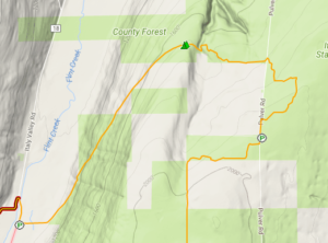
All hikers will meet at the parking area on Italy Valley Rd (42.626312, -77.281368) just north of the Flint Creek crossing at 1:45. All hikers will then carpool up to the top of Italy Hill.
The Climbers will drive South on Italy Valley Rd to Italy Turnpike, then up the hill to Dunn Rd where they will turn left and park at the end of the road. We will hike straight ahead on an abandoned section of the road for 0.7 mi, and then turn right to continue on the trail over to Pulver Rd where we will pass the Tourist cars and continue on the same route they are taking.
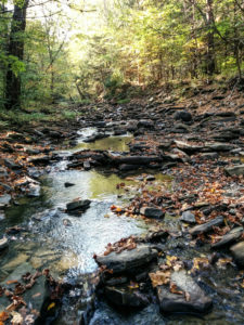
The Tourists will also drive South on Italy Valley Rd, up Italy Turnpike, past Dunn Rd and turn left on Italy Hill, and immediately left again on Pulver Rd. About 2.5 miles up Pulver, there is a parking area. The Tourists then hike north on the abandoned part of Pulver Rd for 0.2 miles and then will turn right into the woods. At 1.5 miles we hike down to the stream and waterfall, then scramble up the other side. At 1.7 miles we will reach the Outback Inn. After a brief rest at the Inn (bring an energy bar since this “Inn” is a carry in/carry out self serve establishment), we will start a long descent to the valley floor.
The Naturalists will carpool with the tourists to Pulver Rd, and will follow them to the waterfall. Turning around at the waterfall will mean a 3.0 mile out and back hike, primarily on flat terrain.
 Upon reaching Italy Valley Rd, the Tourists and Climbers will turn right to follow the road back to the cars. We expect there will be enough cars left at the bottom to get everyone back up to the Tourists and Climbers cars at the top in one trip.
Total mileage, according to the FLT map, will be 5 miles for the Climbers, 3.7 miles for the Tourists and less than 3.0 miles for the Naturalists.
Following the hike, an optional social will be at the Neapolitan Pizzeria at 120 North Main Street in Naples, NY.
Directions
From Springwater, Wayland and Dansville: Take NY-15 south to Wayland. Turn left at the light onto NY 21 N. In 6.7 miles turn left to stay on NY-21. At the stop sign in Naples, turn right on NY 53S. In 1.3 miles, turn left onto Italy Valley Rd. In 7.7 miles, just over the bridge, there if parking for the Bristol Hills Branch. Please arrive at 1:45 to give us time to carpool to the top of the hike.
From Honeoye: Take CR 36 (West Lake Rd) into Naples. Turn right on NY 21S and continue straight onto NY 53S. In 1.3 miles, turn left onto Italy Valley Rd. In 7.7 miles, just over the bridge, there if parking for the Bristol Hills Branch. Please arrive at 1:45 to give us time to carpool to the top of the hike.
NOTE: Just a reminder that we will not be hiking next Sunday on Christmas Eve. Join us on New Years Eve for a 2:00pm hike at Harriett Hollister Spencer Park.
Hike, Ski and Snowshoe at Harriett Hollister Spencer Park
NOTE: BE PREPARED FOR VERY COLD TEMPERATURES. NOAH PREDICTS A HIGH OF 4 DEGREES WITH A WIND CHILL OF -11 DEGREES.
We will meet at the parking lot at the entrance to Harriett Hollister Spencer Park at 2:00PM. Assuming the snow sticks around, bring gear to snowshoe, cross country ski or hike. Hikers may want to bring traction devices. We will break into groups based on the interests of the participants. If you bring an extra pair of snowshoes, you may find someone who would like to try them out. Bring water and snacks and dress appropriately for the weather with layers that are easy to add or subtract.
Hikers on boots or snowshoes will need to avoid walking on the groomed ski trails (carefully groomed by the Rochester Cross Country Ski Foundation). Since the park is a popular winter sports location, some trails may be easy walking even with snow and we will adjust based on conditions and snow depth.
Social:
Because it will be New Year’s Eve, no after hike social is being planned.
Directions:
FROM HONEOYE: From 20A turn south onto County Route 37 and go about 4 miles to the County Route 37/Canadice Hill Road split. Continue south on Canadice Hill Road about 3 miles. Harriett Hollister Spencer Park will be on your left.
FROM SPRINGWATER: Take Route 15A north out of Springwater for one mile and turn right on Wheaton Hill Road. Take the 1st left onto Canadice Rd. Turn right to stay on Canadice Rd. At the county line continue onto Co Rd 37 for 2.0 miles. Turn right onto Luckenbach Hill Rd. At the top, turn left onto Ross Rd. At the stop sign, take a sharp right onto Canadice Hill Rd. Harriett Hollister Spencer Park will be on your right.

NOTE: It’s still hunting season! Please wear bright colors, preferably orange.
The hike on Sunday 7th January 2018 – the first hike of the New Year – will follow a section of the main path of the Finger Lakes Trail in Urbana, just south of Hammondsport. This is the same hike that we attempted in October but had to abandon because of torrential rain. It’s a short easy hike, just 2.6 miles, and it follows the rim of a deep gully cut by the Mitchellsville Creek. This section slopes gently downhill from north to south with just a few short steep sections. The northern two thirds passes through a dense hemlock wood, and the path is a soft bed of hemlock needles; there are views of the deep gully along the way. There are two ‘beauty spots’ along the route; about a third of the way from the top there’s a short side track that juts out over the gorge giving good views from a height, and about two thirds of the way down there is a pretty creek. Unfortunately, we can’t get too close to either spot; this section of the trail is on private land and we can’t wander off it. The gorge overlook is crumbling and is dangerous, and access to the creek is specifically denied by the land owner.
We will meet at the FLT trail head on Route 54 in Urbana, by the Pleasant Valley Inn (42.388729, -77.260357) at 2:00pm.
The Climbers will shuttle to the high point of the hike at FLT access point 5 on Mitchellsville Road (42.404269, -77.290893), and then walk down the FLT back to the meeting point.
The Tourists and Naturalists will start at the meeting point and walk up the trail. They will walk a short distance north on Rt. 88 (it is Hammondsport-Pleasant Valley Road) and then go left on the FLT through a vineyard. At the end of the vineyard the trail crosses a stream and then rises up through the gully to a pretty spot by the creek. There are no steep sections on this stretch. Those who want to can carry on up the trail can do so, but there are some short but more difficult sections to navigate.
The Social
We’ll have a social at the Union Block Italian Restaurant, 31 Shethar Street, Hammondsport; it is right on the village square. This restaurant opens at 4:00pm on Sundays, so there is a danger that we will finish this hike before it opens – it is a short hike this time. We could wait at the Aroma Art coffee shop if we are done hiking too soon.
Directions
From Honeoye: Follow W Hollow Rd (County Road 36) to Naples. Turn Right at the Middletown Tavern on to Rt. 21 South, and then bear left on to NY-53 South. Continue for 17.1 miles through Prattsburg and then turn left to County Rd 13/Mitchellsville Rd in Wheeler. Turn right when this road ends and folow this road (Route 88) to its junction with route 54. The parking area and trail head is on the left.
From Naples: Take NY-21 South, and then bear left on to NY-53 South. Continue for 17.1 miles through Prattsburg and then turn left to County Rd 13/Mitchellsville Rd in Wheeler. Turn right when this road ends and folow this road (Route 88) to its junction with route 54. The parking area and trail head is on the left.
From Rochester: Take NY 15 south to the I-390, and then I-390 South to the NY 54 / Bath exit, then follow NY54 north to the Pleasant Valley Inn.The parking area and trail head is on the left.
From Springwater and Wayland: Take 390 South to the NY 54 / Bath exit, then follow NY54 north to the Pleasant Valley Inn.The parking areaand trail head is on the left.
Springwater Trails is again hosting a hike at Mendon Ponds park the same day as the annual Monroe County Winterfest. The impressive agenda of the 23rd edition of Winterfest is at http://www2.monroecounty.gov/parks-winterfest . Winterfest activities start at 11am, the hike begins at the usual time of 2pm.
 Springwater Trails hikers will meet at the south end of the Beach parking area on Douglas Road, marked with a Purple P on the current map. We will all access the trailhead for the East Esker (Green) and North Meadows (Blue) trails across Douglas Rd.
NOTE: Because of the heightened activity at Mendon Ponds for Winterfest, dog owners should plan to keep their dogs on a short leash. Specifically, dogs should stay away from the Stewart Lodge and the K9 Search & Rescue dog, and from the Seneca Siberian Husky Club Sled Dog Race on South Meadow Trail. The races will be over at 1:00 so our hike should not interfere, but remember to be a responsible dog owner.
Tourists will walk the North Meadow and Pine Woods trails which the map lists at 2.8 miles, mostly flat.
Climbers will follow the East Esker trail for a hilly 4.7 miles.
Following the hike, we will gather at the Brewery Pub and Grill at 8 W Main S in Honeoye Falls for refreshment and warm conversation.
Directions:
From Springwater: Head north on 15A for 21.6 miles through Hemlock and Lima. Take a slight right exit to Honeoye Falls. Stay on W Main St into the villiage where you will pass the Brewery Pub and Grill on the right at the intersection with NY 65 (1.9 mi). Continue straight onto NY 65 for 4.4 mi. (At 2 miles, you will go around a traffic circle. Stay on NY 65.) Turn right onto Pond Rd at the park entrance. Continue straight onto Douglas Rd. when Pond Rd turns right. After rounding the Northward bend on Douglas Rd, look for the Beach Parking area on your left. NOTE: to get to the Evergreen Shelter before the hike for Winterfest events, stay on NY 65 for another 1.2 miles past Pond Rd. Turn right on Canfield Rd. The shelter is on the right 0.7 miles down Canfield.
From Honeoye: From US 20A, head north on CR 37 for 8.2 miles to W Bloomfield. Continue straight on NY 65 for 0.7 miles, then continue straight onto CR 35/W Bloomfield Rd for 6.6 miles. Turn left onto Pond Rd. Inside Mendon Ponds Park, the road will come to a T. Turn right onto Douglas Rd and after rounding the Northward bend on Douglas Rd, look for the Beach Parking area on your left. Note: to get to Winterfest events at the Evergreen Shelter before the hike, stay on W Bloomfield Rd for another 1.7 miles past Pond Rd. Turn left on Canfield Rd. The shelter is on the left 2.1 miles down.
From Rochester: Exit I590 at Monroe Ave toward Pittsford. Turn right (south) onto NY 65 (Clover St). In 6.7 miles, turn left onto Pond Rd. Continue straight onto Douglas Rd. when Pond Rd turns right. After rounding the Northward bend on Douglas Rd, look for the Beach Parking area on your left. NOTE: to get to the Evergreen Shelter before the hike for Winterfest events, turn left from NY 65 in 5.5 miles onto Canfield Rd. The shelter is on the right 0.7 miles down.
From the Evergreen Shelter: Head west on Canfield Rd for 0.7 miles. Turn left onto NY 65 for 1.2 miles. Turn left onto Pond Rd. Continue straight onto Douglas Rd. when Pond Rd turns right. After rounding the Northward bend on Douglas Rd, look for the Beach Parking area on your left.
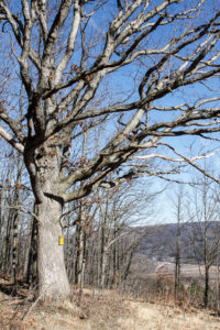
The hike on Sunday 21st January 2018 will follow a section of the Bristol Hills Branch of the Finger Lakes Trail in Naples. Springwater Trails has signed up to maintain this section of the Finger Lakes Trail. This section passes through the West Hill Preserve off Seman Rd and then across private land to Mt Pleasant St. in Naples. This section of trail is also in our plan to walk the entire length of the BHB.
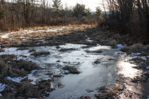
The trail is in good shape provided that there has been no serious winter damage. It rises steadily from the Seman Road access point to the ridge line, and then drops fairly steeply down to Naples. It has been a reliably dry trail in the past apart from a short section of bog near the beginning of the hike. We will be making notes about areas that need maintenance. Maintenance days will be planned in the spring and late summer, to help keep this trail in the conditions that hikers have grown to expect.
We will meet at the entrance to the West Hill Preserve on Seman Road (42.66166, -77.396288). We will shuttle some cars down to the hike end in Naples (42.625950, -77.397304) before we start. The climbers will follow the trail down to the old cemetery in Naples. Naturalists follow the trail to the sign in box and then return to the cars on Seman Road.
Please note: Dogs are not allowed to hike on the Nature Conservancy property.
The Social and the Christmas Party
Following the hike, please join us for a social and late Christmas party at John’s house (42.615870, -77.456155). The address is 8402 French Hill Road, Naples, NY 14512.
Directions to the Hike Meeting Point:
From Springwater: Head south on NY 15 (for 5.2mi). At the light in Wayland turn left on NY 21N (for 6.7mi). In N Cohocton, turn left to stay on NY 21N (for 4.5mi). In Naples, turn left again to stay on NY 21N (for 1.8mi). On the north side of Naples, turn left on CR12 and head up the hill for 1.9 miles. Take the first left, Rhine St., to the 4 way intersection. Go left onto Seman Rd. Trailhead is about 1/2 mile, by a big sign on the left. Park along the road.
From Honeoye: Head south on CR 36 on the west side of Honeoye Lake (for 13.6 miles from NY 20A). Turn left onto Gulick Rd (for 2 mi), then right on Davis Rd (for 0.7mi). At the end of Davis, turn left on W Hollow Rd (CR 33) for 0.5mi, then right on Seman Rd. The Trailhead is about 1 mile, by a big sign on the right. Park along the road.
Directions from the Hike Meeting Point to John’s House (42.615870, -77.456155).
From the meeting point on Seman Road, go west to the junction with West Hollow Road (that’s left, with your back to the trail head). Turn left on to West Hollow Road, and then first right onto Davis Road. At the junction with Gulick Road, turn left and go all the way to the end of the road where it meets County Road 36 (Hunts Hollow Road). Turn right, and half a mile later turn left onto French Hill Road.John’s house is 1 mile up French Hill Road, on the right. It has green siding.
Directions from the Old Cemetery in Naples to John’s House (42.615870, -77.456155).
From the hike end point at Bob and Ruth’s restaurant go south on Rt. 21 through downtown Naples (that’s right with you back to Bob and Ruth’s) and then turn right on county road 36, also known as Hunts Hollow Road; this turn is at the Middletown Tavern. Go north up County 36 for about 2 miles, and then turn left onto French Hill Road. It is the second left after turning onto the road from Rt. 21. John’s house is 1 mile up French Hill Road, on the right. It has green siding.
Post Hike Notes
This hike should be classed as a “hard” hike in winter, and possibly “very hard” if conditions are icy. The section is about 60% gentle uphill in the north, starting at Seman Road, but becomes very steep once the ridge line is crossed. Some parts on that southern section are very steep, and snow and ice make it especially difficult. This hike took 3 hours in moderate snow.
Note: Change of hike location due to hazardous ice conditions on the Middlesex Valley Trail
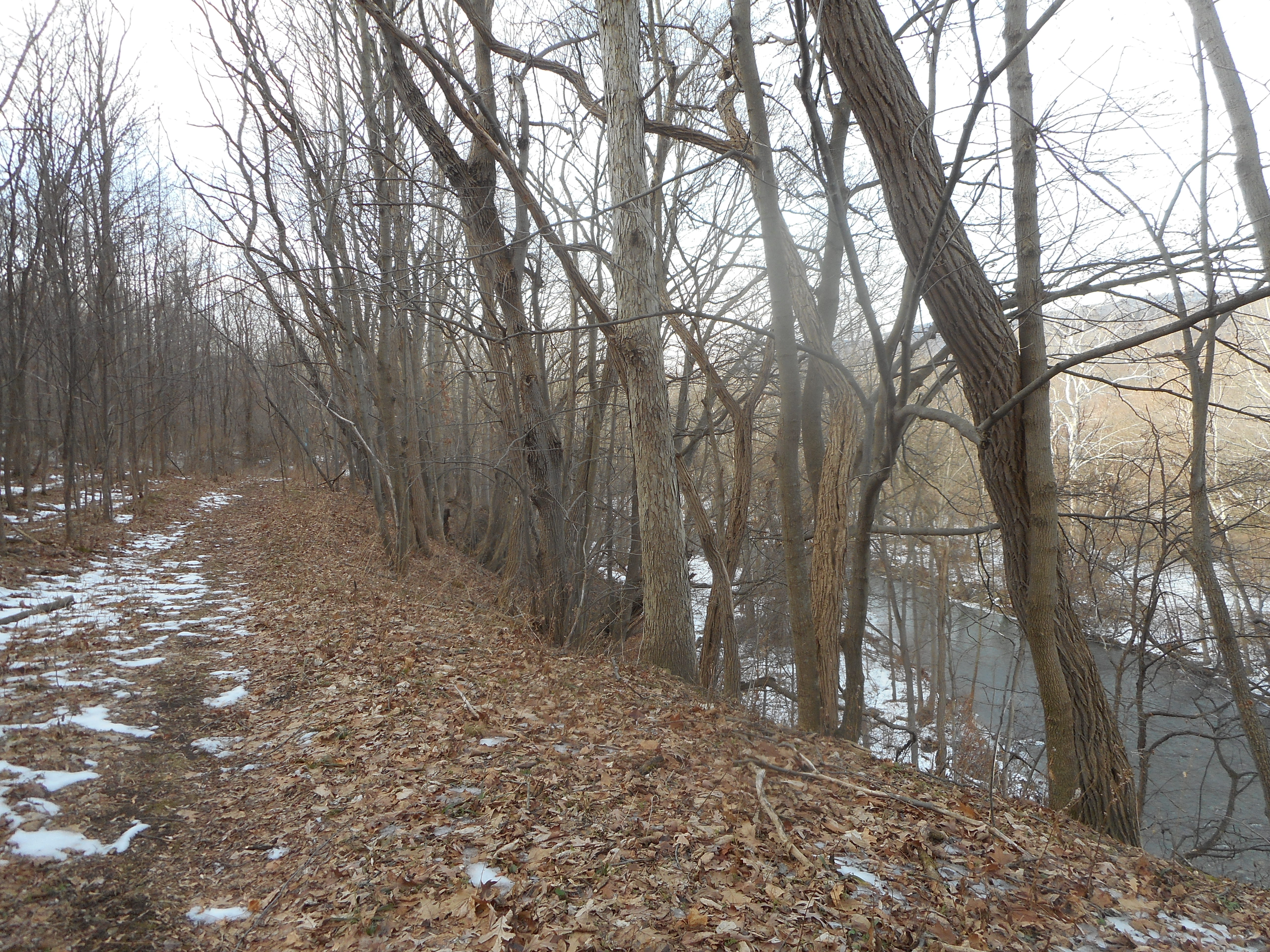
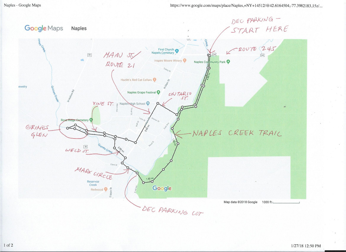 This Sunday we will hike two trails on the outskirts of the Village of Naples, connecting the two with some sidewalk hiking in the village. The first is the Naples Creek Trail, which follows the eastern edge of Naples Creek within the Hi Tor Wildlife Management Area. The second is Grimes Glen Park, a steep and spectacular glen on the west side of the village. Both trails offer splendid creek-side scenery and are partly snow covered with some icy areas underneath, so poles and traction devices are highly recommended. Most of the walk will be on level ground, with one moderate climb and descent in the south half of the Naples Creek Trail. Wear layers, as there may be significant temperature variation.
All hikers will begin together, heading south from the DEC Field Station parking area off Route 245. The Naples Creek Trail starts out just above creek level, and rises in the second half so you are looking down on the creek from part way up the hill. Coming out at a DEC parking area on Mark Circle, we will follow Mark Circle, Main Street and Weld Street to Vine Street and Grimes Glen County Park at the north end of Vine Street. We will hike into Grimes Glen alongside the creek as far as we can go safely – less than 1/2 mile (no hiking on the creek surface) – and then return back on Vine Street to Naples’ historic and picturesque Main Street.
 From here Climbers will head through the business district, past the Neapolitan, and turn right across from the High School on Ontario Street. At the end of Ontario Street is a bridge which will take us back across Naples Creek and back to our starting point, a total of 4.7 miles. Tourists may also leave cars at Mark Circle and hike back to Mark Circle from Grimes Glen, limiting their hike to about 3.5 miles, or skip the Grimes Glen leg of the hike and directly head back to the start along Main and Ontario Streets and the Naples Creek Trail (about 3 miles). Naturalists may leave a car at the DEC lot on Mark Circle, limiting their hike to about 1.6 miles and driving to Grimes Glen for another short hike there if they wish.
Following the hike, please join us for an optional social at the Neapolitan Brick Oven Pizzeria, 120 N. Main St, in Naples.
DIRECTIONS: From Springwater/Dansville/Wayland: Take Rt 21N into Naples. Turn left onto Main St for 1.5 miles. Turn right on Rt#245 (across from Bob and Ruth’s). Continue 0.2 miles, cross Naples Creek, and park on your right outside the DEC Field Station.
 From Honeoye: Take Rt#36 south into Naples, left on Main St for approximately 1.25 miles. Right on Rt#245 (Across from Bob and Ruth’s. Continue 0.2 miles, cross Naples Creek, and park on your right outside the DEC Field Station.
From Canandaigua: Take Rt#21S to Naples. Turn left across from Bob’s and Ruth’s. Continue 0.2 miles, cross Naples Creek, and park on your right outside the DEC Field Station.
Parking Area on Mark Circle: Turn from Main Street onto Mark Circle next to the antique shop. Pass the Town Water Department on your right. There is a DEC Fishing Station parking area on the left, not well plowed – do not park there. Instead go past this lot and go in the next driveway, which has a large cleared lot and picnic tables.
The railroad may have existed between 1899 – 1947, but much is still left today including some stations, a
Historical Society, and a museum with restored railroad cars. Join John Muchler of the Shawmut Historical Society to discuss the history of the
railroad and how the museum in Angelica obtained the original rolling stock.
See the full American Innovation: Winter Discovery Series schedule.
Looking for brochure.or mailing list so I can receive it in the mail.
Nothing opens up for mailing list.
There’s all kinds of very bizarre ads and post for viagra and other drugs above on calender page.
Please let me know if there’s a brochure available