
Hikes led by Springwater Trails are generally held on Sunday afternoons and appear in this calendar in green.
| Sun | Mon | Tue | Wed | Thu | Fri | Sat |
|---|---|---|---|---|---|---|
| Canadice Lake Paddle, Hike and Bike 4:00 pm Canadice Lake Paddle, Hike and Bike @ South Boat Launch Canadice Sep 3 @ 4:00 pm – 6:00 pm 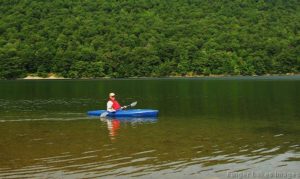 We will explore Canadice Lake and its surrounding terrain with the travel method of your choice, starting at the Canoe Launch (the southernmost lake access point) on Canadice Lake Road (southeast corner of the lake). Meet at 3:45 and park … Continue reading | ||||||
| Mushroom Hike with RAMA 2:00 pm Mushroom Hike with RAMA Sep 10 @ 2:00 pm – 5:00 pm Welcome to the 10th Annual Mushroom Foray [thanks to both Springwater Trails and the Rochester Area Mycological Association] at the All Western Evergreen Farm. Three hiking groups are planned, all starting and ending at the parking area at the farm. The … Continue reading | ||||||
| Hike and Paddle the Honeoye Inlet and the Muller Field Station (42.71266, -77.51203) 2:00 pm Hike and Paddle the Honeoye Inlet and the Muller Field Station (42.71266, -77.51203) Sep 17 @ 2:00 pm – 4:00 pm 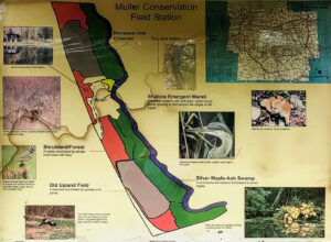 The Muller family land at the south end of Honoeye Lake is now owned by the Finger Lakes Community College (FLCC) and it has expanded into a substantial research and conservation facility. It adjoins DEC land encompassing the rest of … Continue reading | ||||||
| Huckleberry Bog Hike, Prattsburgh 2:00 pm Huckleberry Bog Hike, Prattsburgh Sep 24 @ 2:00 pm – 4:00 pm Please note: This Sunday is the Naples Grape Festival from 10-5, with its notorious traffic jams. We advise avoiding Naples when you plan your trip to Prattsburgh. This hike will be on a section of the Bristol Hills Branch of … Continue reading |
Subscribe
| Sun | Mon | Tue | Wed | Thu | Fri | Sat |
|---|---|---|---|---|---|---|
|
Canadice Lake Paddle, Hike and Bike
4:00 pm
Canadice Lake Paddle, Hike and Bike
@ South Boat Launch Canadice
Sep 3 @ 4:00 pm – 6:00 pm
We will explore Canadice Lake and its surrounding terrain with the travel method of your choice, starting at the Canoe Launch (the southernmost lake access point) on Canadice Lake Road (southeast corner of the lake). Meet at 3:45 and park … Continue reading
|
||||||
|
Mushroom Hike with RAMA
2:00 pm
Mushroom Hike with RAMA
Sep 10 @ 2:00 pm – 5:00 pm
Welcome to the 10th Annual Mushroom Foray [thanks to both Springwater Trails and the Rochester Area Mycological Association] at the All Western Evergreen Farm. Three hiking groups are planned, all starting and ending at the parking area at the farm. The … Continue reading
|
||||||
|
Hike and Paddle the Honeoye Inlet and the Muller Field Station (42.71266, -77.51203)
2:00 pm
Hike and Paddle the Honeoye Inlet and the Muller Field Station (42.71266, -77.51203)
Sep 17 @ 2:00 pm – 4:00 pm
The Muller family land at the south end of Honoeye Lake is now owned by the Finger Lakes Community College (FLCC) and it has expanded into a substantial research and conservation facility. It adjoins DEC land encompassing the rest of … Continue reading
|
||||||
|
Huckleberry Bog Hike, Prattsburgh
2:00 pm
Huckleberry Bog Hike, Prattsburgh
Sep 24 @ 2:00 pm – 4:00 pm
Please note: This Sunday is the Naples Grape Festival from 10-5, with its notorious traffic jams. We advise avoiding Naples when you plan your trip to Prattsburgh. This hike will be on a section of the Bristol Hills Branch of … Continue reading
|
Subscribe
One thought on “Calendar”
Leave a Reply
You must be logged in to post a comment.
Looking for brochure.or mailing list so I can receive it in the mail.
Nothing opens up for mailing list.
There’s all kinds of very bizarre ads and post for viagra and other drugs above on calender page.
Please let me know if there’s a brochure available