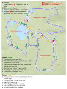
 On Sunday, July 8, nine hikers enjoyed a hike off of Ebert Rd in the Rattlesnake Hill Wildlife Management Area. April provided a map of the area. Please click for a larger image.
The flagged sections are no longer flagged, but you should be able to follow the trails anyway, with the exception of the trail marked 16. You can still walk the open woods if you feel comfortable doing so without a trail.
The group that hiked the north loop reported that there are some trees down that make it difficult to follow the trail in spots. Take care when using this route until the downed trees have been cleared.
You can view the GPS track and April’s hiking journal, which contains other Rattlesnake Hill hikes (and others around NY), for more details. It’s a great place to explore, and not heavily used.
Notes for the Map
See the numbered locations on the Map.
- Barnyard to east, homestead artifacts west of trail
- Follow trail and markers on north loop
- Signs of homestead, old well (was filled in in 2017)
- Kiosk – use trail to the right of it
- Nice walk along bank
- Flag – opening in trees to next pond
- Look for small holes, mud – turtle eggs
- Trail to a parking area on Ebert
- Mud – hug the west side!
- Trail splits – note large tree. Keep to the eastern trail (straight)
- Hint of a trail to the left at a trail marker – stay to the right
- Small rock cairn where trails rejoin
- Trail relocated to east at massive muddy section
- Three Flags at start/end of trail – optional use, muddy section
- Jnctn of flagged route and pond trail **watch for beaver cut stumps
- Flagged trail through open woods
- NE trail end is flagged
- Grassy area with clump of trees
- Grassy trail – watch for ruts
- Stay to east side of grassy trail – homestead artifacts in this area
- Logged area – starting to recover
- Flagged route to horse trail – optional. Or stay on grassy trail
- Homestead plants in woods and field
- Homestead artifacts
- Rock cairn on logs
- Massive mud trail along pond – avoid
- Trail head (not using for this hike)
- West Loop – mostly unmarked
- East Loop – grassy trails unmarked, horse trail has red plastic discs
- Pond becoming bog, geese families here
- Vernal pond
