
Union Corners Rd
New York
USA
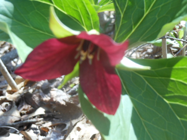
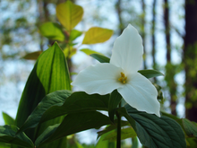 This Sunday, we’re returning to Sonyea State Forest in Livingston County, to hike along the Keshequa Creek and enjoy early spring flowers.
We will meet at 1:45pm at the gate that marks the head of the Keshequa Creek Falls Trail about 2.7 miles from the beginning of Union Corners Rd. See directions below.
All hikers will walk around the gate to a well groomed trail the heads down a steep hill to the creek. Be careful walking down, and on the way back you will want to take your time climbing this hill. But the hill is not long and most of the rest of the trail is along the old Genesee Valley Canal and railroad bed.
Our hike will take us to the western side of the forest, where we will encounter the gorge along Keshequa Creek. Within the gorge, we will see remains of the Genesee Canal and a major branch of the Pennsylvania Railroad, as well as rapids and falls along the creek.
![]() After the hike, we will enjoy an April weather picnic in the woods. Bring a dish to pass, or make a donation. We will select a clear area so, bring folding chairs, and a table, if you have one. There are no washroom facilities, not even portable ones, but lots of trees. If the day should turn out to be a rainy one, we will return to the Sunrise, in Dansville.
After the hike, we will enjoy an April weather picnic in the woods. Bring a dish to pass, or make a donation. We will select a clear area so, bring folding chairs, and a table, if you have one. There are no washroom facilities, not even portable ones, but lots of trees. If the day should turn out to be a rainy one, we will return to the Sunrise, in Dansville.
Directions: Please note: Directions on Google Maps from Springwater takes you on NY 36 North to Craig Rd up through the Groveland Correctional Facility. This road is closed to cars, although walkers and bikers are allowed to use it as part of the Genesee Valley Greenway trail.. This is not a good way to get to our hike. Please follow the directions below.
From exit 6 on 390, turn south on NY 36. Then, take the first right onto CR 72, aka Presbyterian Rd. Follow it for 3.7 miles, bearing right at the intersection with CR 11, to Union Corners Rd. Turn right here and keep going for 2.7 miles,, till you see the gate. Union Corners Rd is unpaved, with potholes, making for slow going so, consider this in planning your travel time. Turn around at the gate and park on either side of the road.
From Springwater: Take NY 15 west from the flashing light. At the top of the hill (1.5 mi), turn left onto Liberty Pole Rd.(CR 38). Continue for 8.1 miles as the road number changes from CR 38 to CR 1A to CR 1. Turn left onto NY 63 S. In just 0.3 miles take the first right onto N 258. In 1.9 miles, continue straight across NY 36 and onto CR 72 (Presbyterian Rd). Follow the directions above to the state forest.
From Naples. Follow NY 21 S to Wayland. At the first light, turn left to stay on NY 21. In 1.8 miles south of Wayland, turn right on I-390 N. In 16 miles, take Exit 6. Turn right onto NY 36. Follow the directions above.
From Rochester: take 390 south to the Sonyea exit.Turn left onto Route 36 and drive a short distance then turn right on to county road 72. Drive a few miles and turn right onto Union Corners Road. Drive a couple of miles where you will enter the Sonyea State Forest. Drive about half a mile in until you reach the parking area. There is some logging going on so the road is a little bumpy but passable.
From Dansville: and points east, take Route 36 north toward Sonyea. Turn left onto CR 72. From there follow the directions above.