
Please join us on August 11 for one of our multi-mode events at Onanda Park on the west side of Canandaigua Lake, 4965 County Road 16, Canandaigua – trail hiking, creek hiking, boating and/or biking. Onanda Park is an 80-acre public property, formerly a YWCA Camp, with 8 acres of level lakefront for water-related recreation and 72 acres of woods and trails on the west side of West Lake Road, including the picturesque Barnes Gully and Barnes Creek. The lakefront and upland sections of the park have different parking fee rules; parking is free in the upland lots, but there is a fee of $10 per car on summer weekends at the lakefront lots. Lakefront walk-ins are free. For details on the park’s facilities, history, and ecosystems, see: http://www.townofcanandaigua.org/portfolio_detail_page.asp?id=5
Meet at 3:45 for a 4 PM start at the upper Upland Parking lot, where we will get organized into groups according to your preferred activity. Hikers will divide into the Climbers and the Tourists/Naturalists, cyclists will head out from here and boaters will drive down to the lakefront lot for easier access to the lake (note the $10/car fee) or walk their boats in. We will reassemble at the cars at 6:00 for our dish-to-pass social in one of the upland lakeview pavilions. Swimming and fishing opportunities are available throughout the afternoon; a lifeguard is on duty until 7 PM.
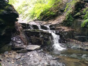 Climbers – will first hike the Upland Loop of about 1.5 miles, then head to Barnes Creek and walk upstream to the waterfall, then downstream to the lake, passing under the West Lake Road bridge. Bring a bathing suit and towel in your pack if you would like to swim after the hike; rest rooms are available for changing. Bring bug repellent and water shoes with good traction for the creek walking section – your feet are guaranteed to get wet. Trails are well maintained and marked, with moderate climbs and descents and two overlooks into Barnes Gully. Poles will be helpful for the uneven surfaces in the stream bed.
Tourists/Naturalists – will hike the Lowlands Loop, then head down to Barnes Creek for some level walking in the water down to the mouth of the creek within the park, where you can sit and watch the action at the fishing pier and the swimming beach. Bring bug repellent and a bathing suit and towel in your pack if you would like to swim after the hike; rest rooms are available for changing. Bring water shoes with good traction for the creek walking section; poles will be helpful too.
Cyclists – will follow West Lake Road to the north as far as Butler Road, then loop over to Middle Cheshire Road and back to West Lake Road for a total of about 11.5 miles. There are two moderate hills to navigate, but most of the trip is at lake level and close to the water, and the road has a good shoulder and a 35 mph speed limit, making it a favorite for cyclists.
Boaters will drive to the lower lots east of West Lake Rd and carry their boats to the water, or carry them in from the upland lot. Portable wheels may prove useful. Once in the water, we will stay near the shore, heading south for a couple of miles toward Seneca Point (about 3 miles south). Bare Hill will be across the lake when we turn around to return to the park.
Social – Bring your own beverage and join us for the optional dish-to-pass social starting at 6 PM in one of the park pavilions (site to be announced at the start). In-lieu-of-cooking fee of $5 if you arrive without edibles.
Directions: From Springwater, go south to Naples, then north on Route 21, bearing right when it splits with Route 64. Five miles after the intersection with Route 64, turn right on County Road 16. In 2 miles, Onanda Park Upland Trails Area will be on your left.
From Honeoye/Hemlock, take Route 20A east toward Bristol. Turn right on County Road 32 at the Wizard of Clay. Continue straight through the intersection at Bristol Center, then at the top of the hill, turn right on Montanye Road, which will take you into Cheshire. At the end of Montanye (now called Goodale Road), go right, then left on Wells Curtice Road. At the end of Wells Curtice Road (in 1.9 miles), make a right on West Lake Road (a.k.a County Road 16). Onanda Park Upland Trails Area will be on your right in 1.6 miles.
From Rochester and points north: Take the Canandaigua or Victor exit from the Thruway, whichever is closer for you. Go south to Route 5&20. From the Canandaigua side, take Middle Cheshire Road to the south end, then go left on Wells Curtice Road and right on West Lake Road (County Road 16). Onanda Park Upland will be on your right in 1.6 miles. From the Victor/Bloomfield side, take Route 64 south to Bristol Center, left on County Road 32, and right on Montanye Road. At the end of Montanye (now called Goodale Road), go right, then left on Wells Curtice Road. At the end of Wells Curtice Road (in 1.9 miles), make a right on West Lake Road (a.k.a County Road 16). Onanda Park Upland Trails Area will be on your right in 1.6 miles.
See http://www.townofcanandaigua.org/page.asp?id=263 for trail map.
Just wanted to check if you are biking. Let me know.