NY 14873
USA
 Linda and I did a pre-hike on Saturday, 9/16/2017, and we have some updated details, which are shown in purple below.
The September Bristol Hills Branch hike will feature a return to Huckleberry Bog in the Urbana State Forest. For hikers who joined Wendy on the hike last November, each route will have enough differences to keep you interested.
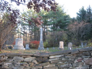
The hike will pass an old cemetery (see below) where we will have a more informal “bring your own sandwich” social following the hike. We will not try to carry the Picnic Tote up to the social, so bring hand food and a drink. A blanket or chair to sit on might also be good.
We will all meet at Access 15 on CR 77, Shuart Rd, just past the “Welcome to Pulteney” sign. Climbers and Naturalists will leave their cars on the shoulder parking area just west of the trail entrance. Others should temporarily park on the shoulder past the entrance.
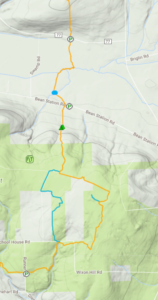
 Climbers will head south on the Orange blazed trail for a total of 4 miles and a climb of 600 ft. The trail crosses Bean Station Rd and passes a restored cemetery and a shelter available to hikers wishing to camp. At the first register, take time to look at the interpretive nature guide books, the work of Irene Szabo and Wayland-Cohocton High School science class and their teacher, Robert Hughes. Climbers should stay on the orange trail around the bog. The blue trail to the left will rejoin in 1.6 miles. At the next register, stay left to the Access 17 and the Tourists cars. Hopefully, we will have met the tourists and borrowed a couple of keys to return their cars down to Bean Station Rd
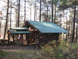
 The Tourists will carpool to the end of their hike at Access 16 on Bean Station Rd, leaving as many cars as possible there. They will then drive enough cars to carry all of the Tourists, and also to carry all of the Climbers back, up to Access 17. There is parking for 3 cars off road. The rest will need to park on the side of the road. In about half a mile there is a registry and the trail goes left and right to start the loop around the bog. You better sign in and note that the climbers are coming the other direction and will sign in at the north register. Stay on the main orange BHB trail to the right. The blue trail is half a mile shorter. The two sides of the loop join at a second register and the main orange trail turns right (north). Its all down hill from here, so watch your step if the ground is wet. When you get to the Evangeline Shelter on the right, the cars at Bean Station Road are 2/10ths of a mile ahead.
 The Naturalists will start the same direction as the Climbers, though at a more relaxed pace. After crossing a small bridge in the middle of a field, the trail will slowly climb about 70 ft to Bean Station Rd. The naturalists, now have the option to continue across Bean Station Rd to the Cemetery and the Shelter. The Naturalists may then hike back to to cars on Shuart Rd for a round trip hike of 2.2 miles, or can use a Tourists car to return to the cars (Please arrange at the start of the hike to keep a spare set of keys with one of the tourist drivers).
Directions:
From Springwater: Take Rt 15 South to Wayland. At the stop light, turn left and follow Rt 21 through North Cohocton (take a left at the stop sign) to the south end of Naples. At the stop sign, turn right onto NY 53S for 12.1 miles. Turn left onto Waldo Rd. Continue straight onto CR 77 (Shuart Rd). In 2.3 miles, parking is on the right hand shoulder just past the “Pulteney” sign. Tourists should temporarily park east of the trailhead.
From Naples and points north: Follow Rt 21S through Naples. Continue straight onto NY 53S. Continue for 12.1 miles. Turn left onto Waldo Rd. Continue straight onto CR 77 (Shuart Rd). In 2.3 miles, parking is on the right hand shoulder just past the “Pulteney” sign. Tourists should temporarily park east of the trailhead.
Directions for Tourists to parking areas:
From CR77 to Bean Station Rd: Continue east on CR77. Take the first right to stay on CR77. Continue straight on Depew Rd when CR77 turns left. Take the first right on Bean Station Rd. The trail crosses the road. Park on the side of the road opposite the trail bridge Leave some cars here for the end of the hike.
To Glenbrook or Runner Rd: Continue west on Bean Station Rd for about 1.5 miles. Turn left onto Colegrove Hill Rd. Follow Colegrove Hill Rd for 2 miles. At the 4 way intersection, turn left on Dinehart Rd. Take the first left onto Glenbrook Rd (aka Runner Rd). There is a small parking area on the right side in about 0.2 miles.
Back to CR77 from Runner Rd: Head down hill (south) from the parking area on Runner Rd. Turn right on Dinehart, and right again onto 2 Rod Road (or Colegrove Hill Rd).Continue to the end of the road. Turn left onto Bean Station Rd. In 1 mile, turn right on Muck Rd. Turn right on CR77 (Shuart Rd). The cars will be on the right in 1.7 miles. Follow the directions to Bean Station Rd above to get back to the cemetery.
